

Singapore, 17 October 2026 – The PSI forecast for 18 Oct 2026 is 150 – 220 (Unhealthy to Very Unhealthy).
1 The PSI forecast and corresponding health advisories should be used for planning next day outdoor activities.
2 For immediate outdoor activities, please check the 1-hr PM2.5 concentration readings and personal guide on our haze microsite (www.haze.gov.sg) or mobile app (myENV).
Update on Hotspot and Haze Situation
3 Showers fell over parts of Singapore today. As at 7pm, the 1-hr PM2.5 concentration readings were 106 – 198 µg/m3, in (Band 2, Elevated / Band 3, High), and the 24-hr PSI was 130 – 199, in the Unhealthy range. Under the influence of southeasterly winds, smoke haze from fires in Kalimantan continued to drift towards Singapore. Smoke haze was also observed over Sumatra.
4 For tomorrow, showers are expected over Singapore and the surrounding region. Winds are forecast to shift to blow from the south-southeast or south, which may reduce the transport of smoke haze from Kalimantan to Singapore. However, some smoke haze from Sumatra may drift towards Singapore.
5 On Monday and Tuesday, more showers are forecast over Singapore and parts of Kalimantan and winds expected to gradually weaken and blow from the southeast or south. This could further decrease the transport of smoke haze from Kalimantan to Singapore, although some smoke haze from Sumatra may drift towards Singapore.
Activity Guidelines
6 The health impact of haze is dependent on one’s health status, the PSI level, and the length and intensity of outdoor activity.
7 For updates, visit our haze microsite (www.haze.gov.sg), the NEA website (www.nea.gov.sg), MSS website (www.weather.gov.sg), mobile app (myENV) or follow us on NEA Facebook (www.facebook.com/NEASingapore). For information on the distribution of hotspots detected over the past fortnight in the region, please refer to the ASEAN Specialised Meteorological Centre (ASMC) website at http://asmc.asean.org.
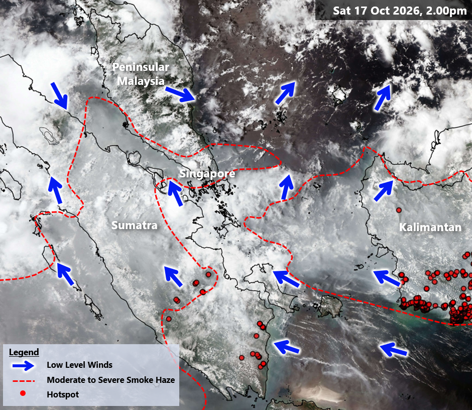
Areas with lighter smoke haze are not indicated as they cannot be clearly discerned from satellite imagery. The full extent of the hotspot and smoke haze situation could not be determined due to extensive cloud cover.
– End –