Singapore, 1 April 2025 – The Northeast Monsoon conditions prevailing over the region since mid-November 2024 are expected to gradually weaken and end, with inter-monsoon conditions setting in during the first fortnight of April 2025. The inter-monsoon period usually lasts to May, and is characterised by light and variable winds and higher lightning activity.
2 Moderate to heavy thundery showers are expected over parts of the island in the afternoon on most days. The showers may extend into the evening on a few of these days. In addition, Sumatra squalls may bring widespread thundery showers and gusty winds on one or two mornings. The total rainfall for the first fortnight of April 2025 is forecast to be above average over most parts of the island.
3 The daily maximum temperatures are likely to range between 33 degrees Celsius and 34 degrees Celsius on most days and reach around 35 degrees Celsius on a few days.
4 For updates of the daily weather forecast, please visit the MSS website (https://www.weather.gov.sg), NEA website (www.nea.gov.sg), or download the myENV app.
REVIEW OF THE PAST TWO WEEKS (17 – 31 MARCH 2025)
5 Northeast Monsoon conditions prevailed over Singapore and the surrounding region in the second fortnight of March 2025. During the period, the low-level winds blew mainly from the northwest or northeast.
6 The second fortnight of March 2025 was very wet. Moderate to heavy thundery showers affected parts of the island on most days. On 19 – 20 March 2025, a surge of north-easterly winds (or monsoon surge[1]) over the South China Sea brought spells of moderate to heavy showers over Singapore and the surrounding region. This was the third wet monsoon surge during this Northeast Monsoon season. The daily total rainfall of 216.8 mm recorded at Kallang on 20 March 2025 was the highest rainfall recorded for the second fortnight of March 2025.
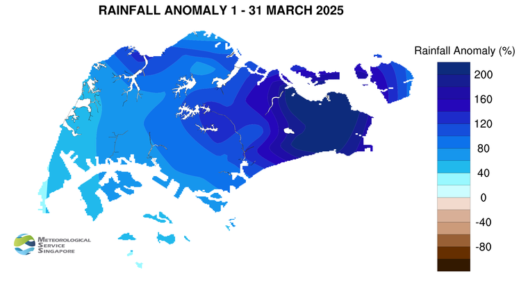
7 Based on the rainfall averaged across the island-wide stations with long-term data since 1980, March 2025 is the wettest March on record. The monthly total rainfall of 482.9 mm surpassed the previous record of 451.0 mm set in 2004.
8 The daily maximum temperatures in the second fortnight of March 2025 were between 32 degrees Celsius and 34 degrees Celsius on most days. During the monsoon surge on 19 – 20 March 2025, the daily minimum temperatures ranged from about 22 degrees Celsius to 24 degrees Celsius, while daily maximum temperatures ranged from about 24 degrees Celsius to 28 degrees Celsius. The lowest daily minimum temperature for the second fortnight of March 2025 was 21.9 degrees Celsius, recorded at Tuas South during the surge on 20 March 2025.
9 Well-above average rainfall was received across the island in the second fortnight of March 2025 with Changi registering rainfall of 570 per cent above average.
[1] A monsoon surge refers to a strengthening of winds over the South China Sea, causing extensive rainclouds to form over our surrounding region.
Figure 1:
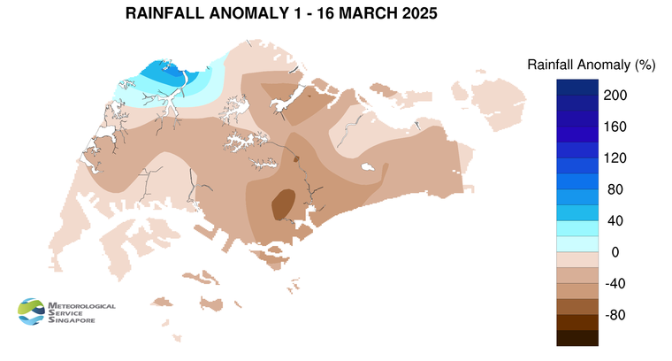
Figure 2:
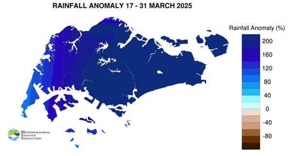
Figure 3:
CLIMATE STATION STATISTICS
Long-term Statistics for April
(Climatological reference period: 1991 – 2020)
| Average daily maximum temperature: | 32.4 °C |
| Average daily minimum temperature: | 25.3 °C |
| Average monthly temperature: | 28.2 °C |
| Average rainfall: | 164.3 mm |
| Average number of rain days: | 15 |
Historical Extremes for April
(Rainfall since 1869 and temperature since 1929)
| Highest monthly mean daily maximum temperature: | 33.9 °C (1983) |
| Lowest monthly mean daily minimum temperature: | 23.1 °C (1934) |
| Highest monthly rainfall ever recorded: | 454.9 mm (1900) |
| Lowest monthly rainfall ever recorded: | 16.6 mm (1977) |