1 April 2026 – The Northeast Monsoon conditions prevailing over the region since December 2025 are forecast to gradually weaken and end, with inter-monsoon conditions setting in during the first week of April 2026. The inter-monsoon period usually lasts to May and is characterised by light and variable winds and higher lightning activity.
2 The first fortnight of April 2026 is expected to be wetter than the past fortnight, with thundery showers forecast over parts of Singapore in the afternoon on most days. The showers may extend into the evening on a few of these days. In addition, Sumatra squalls may bring widespread thundery showers and gusty winds on one or two mornings. The total rainfall for the first fortnight of April 2026 is forecast to be near average over most parts of the island.
3 While more showers are expected in the first fortnight of April 2026, the daily maximum temperatures may still range between 33 degrees Celsius and 35 degrees Celsius on most days. The daily maximum temperatures may exceed 35 degrees Celsius on a few days when there is less cloud coverage.
4 For updates of the daily weather forecast, please visit the MSS website (https://www.weather.gov.sg), NEA website (www.nea.gov.sg), or download the myENV app.
REVIEW OF THE PAST TWO WEEKS (16 – 31 March 2026)
5 Northeast Monsoon conditions prevailed over Singapore and the surrounding region in the second fortnight of March 2026. During this period, the low-level winds blew mainly from the north or northeast.
6 There were several fair days in the second fortnight of March 2026. Short-duration thundery showers fell over parts of the island in the afternoon on a few days. On 17 March 2026 and18 March 2026, localized thundery showers affected the southern and western part of Singapore in the afternoon. The daily total rainfall of 58.4mm recorded at Tuas South on 17 March 2026 and at Lim Chu Kang on 18 March 2026 was the highest rainfall recorded for the second fortnight of March 2026.
7 The second fortnight of March 2026 was warm, with the daily maximum temperatures registering above 34 degrees Celsius on most days. The highest daily maximum temperature of 35.4 degrees Celsius was recorded at Sembawang on 30 March 2026.
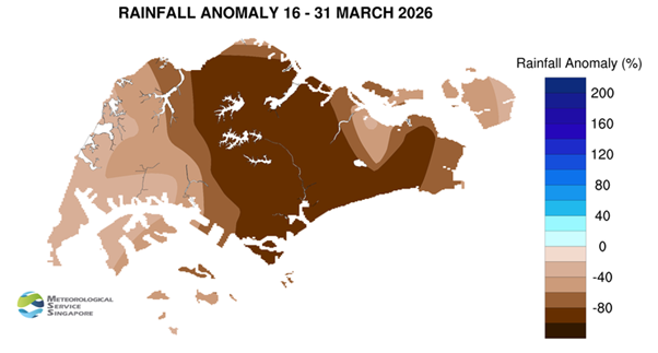
8 Many areas across the island registered well below average rainfall in the second fortnight of March 2026.
CLIMATE STATION STATISTICS
Long-term Statistics for April
(Climatological reference period: 1991 – 2020)
| Average daily maximum temperature: | 32.4 °C |
| Average daily minimum temperature: | 25.3 °C |
| Average monthly temperature: | 28.2 °C |
| Average rainfall: | 164.3 mm |
| Average number of rain days: | 15 |
Historical Extremes for April
(Rainfall since 1869 and temperature since 1929)
| Highest monthly mean daily maximum temperature: | 33.9 °C (1983) |
| Lowest monthly mean daily minimum temperature: | 23.1 °C (1934) |
| Highest monthly rainfall ever recorded: | 454.9 mm (1900) |
| Lowest monthly rainfall ever recorded: | 16.6 mm (1977) |