Fortnightly Weather Outlook for 1 – 15 October 2020
Singapore, 1 October 2020 – According to the Meteorological Service Singapore, more thundery showers are expected in the first fortnight of October 2020. During the period, the daily temperature is forecast to range between 24°C and 33°C on most days, with lows of around 22°C on a few days.
2 The prevailing Southwest Monsoon conditions are expected to persist in the two weeks ahead. During the period, the low-level winds are forecast to continue blowing from the southeast or southwest and may strengthen to blow from the southwest or west in the latter part of the fortnight under the influence of developing low pressure systems over the South China Sea.
3 In the first fortnight of October 2020, with the monsoon rain band forecast to lie closer to the equatorial Southeast Asia region, more rain can be expected over Singapore. During the period, short-duration moderate to heavy thundery showers are forecast between the late morning and afternoon on some days due to strong solar heating of land areas. On a few of these days, the showers could continue into the evening over some parts of the island. In the latter half of the fortnight, strong convergence of winds in the surrounding vicinity and the passage of Sumatra squalls are expected to bring widespread moderate to heavy thundery showers with occasional gusty winds between the predawn hours and morning on several days. In addition, thundery showers can be expected on a few nights. The rainfall for the first fortnight of October 2020 is forecast to be above average over most parts of the island.
4 For the next two weeks, the daily temperature is forecast to range between 24°C and 33°C on most days. On one or two days, the daily maximum temperature could rise to around 34°C. On a few rainy days, daily lows of around 22°C can be expected.
5 For updates of the daily weather and haze situation, please visit the MSS website (https://www.weather.gov.sg), NEA website (www.nea.gov.sg), or download the myENV app, MSS’ Weather@SG app, and the haze microsite (www.haze.gov.sg).
REVIEW (1 – 30 September 2020)
6 Southwest Monsoon conditions prevailed over the region in September 2020. The low-level winds blew from the southeast or southwest on most days, and from the east or west on a few days.
7 September 2020 was relatively wet and occasionally windy. Thundery showers fell over the island in the late morning and afternoon on most days, and on a few days, the rain continued into the evening. Under the influence of large-scale convergence of winds over Singapore and the surrounding vicinity, moderate to heavy thundery showers fell over the island on several nights. On the morning of 10 September 2020, heavy thundery showers fell over the western part of Singapore. The total daily rainfall recorded that day was 129.6mm at Tuas South, which is the highest total rainfall recorded in a day for September 2020.
8 The wet and cloudy conditions brought cooler temperatures on some days around mid-September 2020. The lowest daily maximum temperature in September 2020 was 28.3°C recorded at East Coast and Sembawang on 5 and 13 September 2020 respectively. Both days were associated with island-wide thundery showers that fell throughout most parts of the day. The lowest daily minimum temperature in September 2020 was 20.9°C recorded at Newton on 16 September 2020, associated with a Sumatra squall that brought heavy thundery showers and gusty winds over the island in the early hours of the morning. The last time that the temperature dipped below 21.0 °C was on 8 May 2019 when a minimum temperature of 20.8 °C was recorded.
9 There were a few warm days in September 2020 with daily maximum temperatures reaching around 34.0°C. On 22 September 2020, with relatively clear skies and presence of high-level clouds, a halo formed by the refraction of light through ice crystals in the high clouds was spotted encircling the sun around noon.
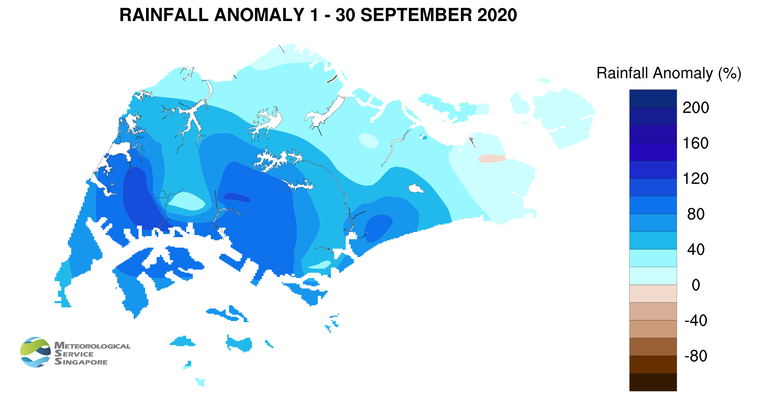
10 With a monthly total rainfall of 150.2mm recorded at the Changi climate station, September 2020 is the second wettest September in the last 10 years after September 2013 (257mm). September 2020 is the coolest September in the last 10 years. It ties with September 2013, with a monthly mean temperature of 27.5°C, 0.1°C lower than the long term September average.
11 Almost all parts of the island received well above-normal rainfall in September 2020. The highest anomaly of 121% above average was recorded at Jurong West. The anomaly was lowest at Changi at 1% below average.
CLIMATE STATION STATISTICS
Long-term Statistics for October
(Climatological reference period: 1981 – 2010)
| Average daily maximum temperature |
31.7°C |
| Average daily minimum temperature |
24.7 °C |
| Average monthly temperature |
27.6 °C |
| Average rainfall |
154.6 mm |
| Average number of rain days |
15 |
Historical Extremes for October
(Rainfall since 1869 and temperature since 1929)
| Highest monthly mean daily maximum temperature: |
33.0 °C (2002) |
| Lowest monthly mean daily minimum temperature: |
22.8 °C (1964) |
| Highest monthly rainfall ever recorded: |
497.1 mm (1942) |
| Lowest monthly rainfall ever recorded: |
10.8 mm (2002) |