Earthquakes and Volcanoes - Weather Information Portal
- Share this page


The earth’s crust is in constant motion, leading to seismic and volcanic activity that is both threatening and awe-inspiring
The outer layer of the solid earth, the crust, is divided into tectonic plates, with Singapore located on the stable portion of the continental Eurasian Plate. These tectonic plates are in constant and gradual motion and when one plate is forced beneath the other, a process known as subduction, both deformation and melting of the crust can occur. This is the underlying reason for earthquakes and volcanoes at plate boundaries. The “Pacific Ring of Fire” is an informal name for the plate boundaries that encircle the Pacific Ocean. This seismically and volcanically active region stretches from New Zealand in the Western Pacific, through Indonesia, the Philippines, Japan, Russia, Canada, the United States of America, Mexico, Peru and Chile on the Eastern Pacific.
The major fault zones in Singapore’s region are shown in the figure below.
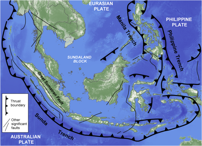 Zone of convergence between the Australian, Eurasian and Philippine Plates. Significant faults are marked. Thrusts are where compression leads to shortening of the crust across the fault zone. Subduction of one plate beneath another occurs along the Sunda Trench, Manila Trench and Philippine Trench. (Image after Metcalfe, 2011, Geological Society of London Special Publications.)
While the motions of the tectonic plates create stresses within as well as at the boundaries between plates, the boundaries between tectonic plates are where the crust often experiences the greatest stress. High levels of stress sometimes causes weaker areas of the crust to rupture, causing breaks in the crust known as faults. Faults can experience no movement and be undetectable for many years because friction ‘locks’ their surfaces and causes build-up of stress along the fault. When enough stress has been built up to overcome this friction, there is sudden movement of the tectonic plates and this is known as an earthquake.
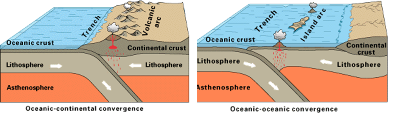 Two examples of subduction involving oceanic and continental crust (left), and oceanic and oceanic crust (right). Earthquakes caused by subduction can be highly devastating. The lithosphere and asthenosphere describe regions of the solid earth with differing physical properties (Image taken from the United States Geological Survey).
Earthquakes vary greatly in size and impact from barely detectable micro-tremors to massive and destructive events such as the magnitude 9.2 Sumatra-Andaman earthquake on 26 December 2004. While most earthquakes occur along the boundaries between tectonic plates, earthquake-generating faults can also be located within a tectonic plate. The largest earthquakes tend to occur at subduction zones between tectonic plates. For our region, the Sunda Trench (along Sumatra and Java), and the Manila Trench (off the Philippines coast) are where many large earthquakes are sited.
The point within the earth where an earthquake is initiated is called the hypocentre (sometimes also known as the focus). This is usually located below the ground’s surface, at a depth of tens or even hundreds of kilometres. The term epicentre is used to describe the point on the ground’s surface directly above the hypocentre. The ‘depth of the earthquake’, generally the distance between the epicentre and the hypocentre, is an important earthquake parameter as shallower earthquakes tend to be more damaging than deeper ones.
The magnitude of the earthquake describes its size. While most people have heard of the “Richter scale”, it is considered outdated due to its limitations. Most scientists now use the improved “moment magnitude” scale, although the moment magnitude scale is equivalent to the Richter scale for smaller earthquakes. For the moment magnitude scale, each unit increase in moment magnitude corresponds to approximately a 32-fold increase in energy released by the earthquake.
Due to complexities in both the solid earth’s composition as well as the response of tectonic plates to stress, earthquakes cannot be predicted in the same way we forecast weather. Geoscientists are therefore unable to predict the precise location and time of an earthquake. Instead, they identify zones with higher risks of earthquake occurrence. Where high quality data is available, it is possible to estimate the likelihood of an earthquake occurring in a particular zone over a period of years or decades. Earthquake forecasting and prediction remains an active area of research.
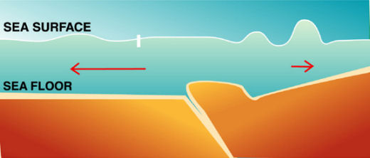
A tsunami is a series of large waves formed in the sea or near the coast that is usually generated by submarine earthquakes, landslides or the collapse of a volcano during an eruption. The most powerful tsunami can travel over thousands of kilometres in hours and can reach enormous heights at the coast.
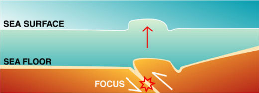 First phase: The earthquake displaces a column of water above it
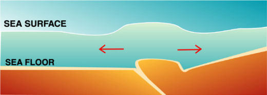 Second phase: the water column spreads in all directions from the initial displacement
 Third phase: the waves now propagate across the ocean
(Image credit: International Tsunami Information Centre)
Where earthquakes are the underlying cause, the most devastating tsunami occur when a submarine large-magnitude ‘thrust’ earthquake occurs at a shallow crustal depth (see figures above). This combination tends to generate very large displacements of water. This was the case in the Sumatra-Andaman earthquake which triggered the Boxing Day Tsunami, and the Tohoku earthquake and tsunami on 11 March 2011 which led to the Fukushima nuclear accident. An example of a tsunami not caused by earthquakes is the tsunami triggered by the collapse of Anak Krakatau during its eruption on 22 December 2018.
Singapore is relatively sheltered from tsunami as it is surrounded by land masses and shallow seas. Nevertheless, MSS maintains a tsunami early warning system and will issue advisories to the public if necessary.
The boundaries between tectonic plates are where the crust often experiences the greatest stress. When one plate is forced beneath the other, a process known as subduction, both deformation and melting of the crust can occur. This is the underlying reason for earthquakes and volcanoes at plate boundaries.
The behaviour of volcanoes is closely related to the chemical composition of their magma/lava. This is in turn a function of their location and geological history. This is why there are such pronounced differences between the gentle eruptions and dark lava of volcanoes on Hawaii versus the more explosive eruption seen at Mount Pinatubo in the Philippines, in June 1991.
Southeast Asia is one of the most active volcanic regions in the world. However, the effects are seldom felt by Singapore as we are hundreds of kilometres from the nearest volcano, and because the area of ash fall is controlled by the wind direction.
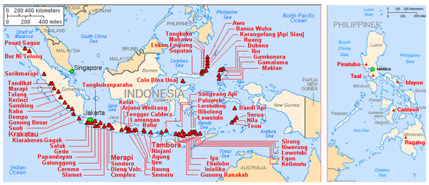 Major active volcanoes in Indonesia and the Philippines (Image credit: USGS)
Singapore is not affected by the kinds of hazards experienced in the immediate vicinity of a volcano. However on the occasions when a volcanic eruption is sufficiently large and the winds are blowing towards Singapore, ash emissions can affect the air quality in Singapore. The severity and duration of such an event can vary. Fortunately, such occurrences are relatively rare: The last documented case was the eruption of Mount Pinatubo in Luzon Island, Philippines in June 1991. The air quality in Singapore went into the moderate or unhealthy range for 3 days (Based on the new PSI scale with 24-hour PM2.5 included, the readings were 91, 112 and 91 for 17, 18 and 19 June respectively.) following the volcanic eruption on 14 Jun 1991. Air travel in Singapore was not affected despite major disruptions close to Pinatubo itself.
All the different components of the earth (atmosphere, oceans, ice, land, the subsurface and living organisms) interact with one another. However earthquakes neither affect everyday weather nor are affected by it.
Volcanic eruptions, in contrast, can affect the weather and this is well documented. Volcanoes tend to release large amounts of sulphur dioxide. Volcanoes also release ash particles at a range of sizes, which can attract water droplets and could possibly have an effect on the electrical charge around them. In the vicinity of a volcano, it is common to observe rain, lightning, and thunder. Large eruptions can have a global scale, multi-year effect. The ash and gases from large eruptions can be transported globally by high-level winds. Sulphur dioxide and other aerosols are known to have a ‘dimming’ effect. This was why the June 1991 eruption of Mount Pinatubo in the Philippines led to slightly cooler than usual temperatures worldwide, in some regions by as much as 0.5 degrees C. A similar phenomenon occurred in April 1815 when Tambora erupted in Indonesia. Tambora is thought to have lowered global temperatures by as much as 3 degrees Celsius, and in parts of Europe and North America, 1816 was known as “the year without a summer.”