Monthly Archives: December 2020

December 31, 2020

Wet and Windy Start to the New Year

Fortnightly Weather Outlook for 31 December 2020 – 15 January 2021


Singapore, 31 December 2020 – The prevailing Northeast Monsoon conditions in the region are forecast to persist into January 2021, with low-level winds blowing from the northwest or northeast. At the start of the new year, a high-pressure system over the northern Asian continent is expected strengthen and bring cooler conditions over the region.

2       In the first week of the year, with the strengthening of the high-pressure system, a surge of strong north-easterly winds (or monsoon surge) is expected over the South China Sea. This is forecast to bring windy and cooler conditions with periods of moderate to heavy showers over Singapore and the surrounding vicinity on two to three days.

3       On most days in the fortnight, moderate thundery showers due to strong solar heating of land areas are expected in the afternoon and may extend into the evening on some days. On a few days, large-scale convergence of winds in the region could bring heavy and widespread thundery showers over the island. Overall, the rainfall for first half of January 2021 is expected to be above average over most parts of the island.

4      The monsoon surge in early January 2021 is also expected to bring cooler daily temperatures of between 22 °C and 31 °C on a few days. For the rest of the fortnight, the daily temperatures are forecast to range between 23 °C and 33 °C. The daily maximum temperature may still reach a high of up to 34 °C on one or two days.

5      For updates of the daily weather forecast, please visit our MSS website (https://www.weather.gov.sg), NEA website (www.nea.gov.sg), or download the MSS’ Weather@SG app, and/or the myENV app.


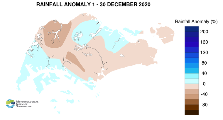
REVIEW (1 – 30 December 2020)

6      In December 2020, Northeast Monsoon conditions prevailed over Singapore and the surrounding region. During this period, the low-level winds blew from the northwest or northeast.

7      During the month, short-duration moderate to heavy thundery showers fell over the island mostly between the afternoon and evening. On a few days, the showers extended into the night. On 26 December 2020, strong solar heating of land areas coupled with localised convergence of winds brought heavy thundery showers over many parts of the island. The daily total rainfall recorded that day was 108.4mm at Mandai. This was the highest total rainfall in a day for December 2020.

8      The daily temperature in December 2020 ranged between 22.2 °C and 35.1 °C . The highest daily maximum temperature of 35.1 °C was recorded on Christmas Day at Admiralty. The lowest daily minimum temperature of 22.2 °C was recorded at Sembawang on 28 December 2020. While it rained over the island on most days of the month, the mean monthly temperature of 27.2 °C for December 2020 at the Changi climate station was 0.8 °C higher than the month’s long-term average.

9      Many parts of the island recorded near average rainfall in December 2020, except for a few parts of western Singapore where rainfall was below average. Around the Choa Chu Kang area, rainfall was 39% below average.


CLIMATE STATION STATISTICS

Long-term Statistics for January
(Climatological reference period: 1981 – 2010)

Average daily maximum temperature 30.4 °C
Average daily minimum temperature 23.9 °C
Average monthly temperature 26.5 °C
Average rainfall 234.6 mm
Average number of rain days 13


Historical Extremes for January
(Rainfall since 1869 and temperature since 1929)

Highest monthly mean daily maximum temperature: 31.8 °C (1998, 2016)
Lowest monthly mean daily minimum temperature: 21.6 °C (1934)
Highest monthly rainfall ever recorded: 818.6 mm (1893)
Lowest monthly rainfall ever recorded: 15.4 mm (1997)


December 15, 2020

Less Wet Weather Expected for Second Half of December 2020

Fortnightly Weather Outlook for 15 – 31 December 2020


Singapore, 15 December 2020 – The weather in the second fortnight of December 2020 is forecast to be less wet compared to the first fortnight of the month. During the coming fortnight, the prevailing Northeast Monsoon conditions are expected to persist and the low-level winds over Singapore are forecast to continue blowing from the northwest or northeast.

2       In the second fortnight of December 2020, the north-easterly winds over the South China Sea and Singapore are forecast to weaken. During this period, short-duration thundery showers due to strong day-time heating of land areas coupled with localised convergence of winds in the surrounding vicinity, are expected over parts of the island in the afternoon on most days. The showers may extend into the evening on a few days. Also in the fortnight, a brief strengthening of northerly winds can be expected. This could bring windy conditions with occasional showers on one or two days. Overall, the rainfall for December 2020 is expected to be below average over most parts of the island.

3      In the coming fortnight, the daily temperature on most days is forecast to range between 24°C and 33°C. Warm conditions with maximum day-time temperatures of around 34°C in the afternoon can be expected on days when there is little or no rainfall.

4      For updates of the daily weather forecast, please visit our MSS website (https://www.weather.gov.sg), NEA website (www.nea.gov.sg), or download the MSS’ Weather@SG app, and/or the myENV app.


REVIEW (1 – 14 December 2020)

5      Northeast Monsoon conditions prevailed in the first half of December 2020 with low-level winds blowing from the northwest or northeast on most days.

6      During the first two weeks of December 2020, strong solar heating of land areas coupled with localised convergence of winds brought short-duration moderate to heavy thundery showers over the island on most days. The showers fell mostly in the afternoon, and on few days, extended into the evening. The heavy thundery showers that fell over many areas of the island on 14 December 2020 recorded a daily total rainfall of 94.0mm at Choa Chu Kang. This was the highest total rainfall in a day for the first half of December 2020.

7      In the first half of December 2020, the daily temperature ranged between 22.4°C and 34.4°C. The highest daily maximum temperature recorded was 34.4°C on 8 December 2020 at Paya Lebar. The daily minimum temperature on most days ranged between 23°C and 24°C, and the lowest minimum temperature recorded during the period was 22.4°C on 11 December 2020 at Sembawang.

8      About half of the island recorded below average rainfall in the first half of December 2020. The highest anomaly of 56% below average was recorded at Admiralty. The rainfall recorded at Pasir Ris was 55% above average.


CLIMATE STATION STATISTICS

Long-term Statistics for December
(Climatological reference period: 1981 – 2010)

Average daily maximum temperature 30.2 °C
Average daily minimum temperature 24 °C
Average monthly temperature 26.4 °C
Average rainfall 318.6 mm
Average number of rain days 18


Historical Extremes for December
(Rainfall since 1869 and temperature since 1929)

Highest monthly mean daily maximum temperature: 31.6 °C (2016, 2018)
Lowest monthly mean daily minimum temperature: 21.9 °C (1933)
Highest monthly rainfall ever recorded: 765.9 mm (2006)
Lowest monthly rainfall ever recorded: 62.5 mm (1932)


December 1, 2020

Prevailing Northeast Monsoon to Bring More Showers in the Next Fortnight

Fortnightly Weather Outlook for 1 – 15 December 2020


Singapore, 1 December 2020 – The prevailing Northeast Monsoon conditions in the region are expected to persist over the next few months. During the period, the low-level winds are forecast to blow from the northwest or northeast.

2     Climatologically, December is the wettest month of the year. In the first fortnight of December 2020, with the monsoon rain band forecast to lie close to the equator, more showers can be expected over Singapore and the surrounding region. Short-duration moderate to heavy thundery showers are forecast over parts of the island in the afternoon on most days. These showers may extend into the evening on a few occasions. On a few days, the thundery showers could be intense and widespread due to large-scale convergence of winds over Singapore and the surrounding vicinity. A strengthening of the north-easterly winds can be expected in the latter half of the fortnight. This is forecast to bring occasionally windy conditions on some days. The rainfall for the first fortnight of December 2020 is expected to be near-normal over most parts of Singapore.

3      In the coming fortnight, the daily temperature is forecast to range between 24°C and 33°C on most days, and may reach 34°C on one or two days. On a few rainy days, daily lows of around 22°C can be expected.

4      For updates of the daily weather forecast, please visit our MSS website (https://www.weather.gov.sg), NEA website (www.nea.gov.sg), or download the MSS’ Weather@SG app, and/or the myENV app.


REVIEW (1 – 30 November 2020)

5      Inter-monsoon conditions prevailed for most parts of November 2020 where the prevailing winds were generally light and variable in direction. A change in low-level winds to blow from the northwest or northeast in the last week of November 2020 signalled the cessation of the inter-monsoon period and the start of the Northeast Monsoon season.

6      Singapore experienced generally wet conditions in November 2020. The thundery showers fell in the afternoon on most days and on a few occasions extended into the night. On a few of these days, the thundery showers were intense and widespread. The wet weather can be attributed to strong solar heating of land areas coupled with large scale convergence of winds over Singapore and the surrounding vicinity. On 2 November 2020, intense thundery showers fell over many parts of the island. The daily total rainfall recorded that day was 134.2mm at Paya Lebar. This was the highest total rainfall in a day for November 2020.

7      While the prevailing La Niña conditions may have an influence on the rainfall in November 2020, other sources of variability such as monsoonal and local wind conditions play a more dominant role in modulating the weather conditions on a day-to-day basis.

8      There were a few warm days in November 2020, mainly in the first fortnight of the month. The highest daily maximum temperature of 34.9°C was recorded at Clementi and Paya Lebar on 5 and 12 November 2020 respectively. In the second fortnight of November 2020, rainy weather and cloudy skies brought cooler temperatures. The lowest daily minimum temperature of 22.3°C was recorded at Pulau Ubin on 28 November 2020. At the climate station in Changi, November 2020 recorded a monthly mean temperature of 27.2°C, making November 2020 the second coolest November in the past 10 years.

9    In November 2020, rainfall was above average over most parts of the island. The highest anomaly of 78% above average was recorded at Paya Lebar. The rainfall anomaly was lowest at Queenstown at 19% below average.


CLIMATE STATION STATISTICS

Long-term Statistics for December
(Climatological reference period: 1981 – 2010)

Average daily maximum temperature 30.2 °C
Average daily minimum temperature 24 °C
Average monthly temperature 26.4 °C
Average rainfall 318.6 mm
Average number of rain days 18


Historical Extremes for December
(Rainfall since 1869 and temperature since 1929)

Highest monthly mean daily maximum temperature: 31.6 °C (2016, 2018)
Lowest monthly mean daily minimum temperature: 21.9 °C (1933)
Highest monthly rainfall ever recorded: 765.9 mm (2006)
Lowest monthly rainfall ever recorded: 62.5 mm (1932)