Monthly Archives: November 2020

November 16, 2020

Wet Weather to Continue for Rest of November 2020 as Northeast Monsoon Sets In by End of the Month

Fortnightly Weather Outlook for 16 – 30 November 2020


Singapore, 16 November 2020 – Inter-monsoon conditions with low level winds that are light and variable in direction have been prevailing over Singapore since the start of November 2020. In the second half of November 2020, the low-level winds are forecast to gradually strengthen and shift to blow from the northeast or northwest around the end of the month. This change in monsoonal winds signal the start of the Northeast Monsoon season, and is expected to extend into March 2021.

2      With the monsoon rain band forecast to continue to lie over the equatorial Southeast Asia region for the rest of the month, the second half of November 2020 is expected to be as wet as the first half of the month. During this period, short-duration moderate to heavy thundery showers are expected over parts of the island in the afternoon on most days. There could be a few days where the showers may extend into the evening. On one or two days where the winds are forecast to blow from the southwest or west, the passage of Sumatra squalls is expected to bring widespread thundery showers and gusty winds over the island between the predawn and early morning. The rainfall for November 2020 is likely to be above average over most parts of Singapore.

3      The daily temperature on most days in the second fortnight of November 2020 is forecast to range between 24°C and 34°C. Although showers are expected on most days of the fortnight, the daily maximum temperature could still reach a high of around 35°C on one or two days.

4       For updates of the daily weather and haze situation, please visit the MSS website (https://www.weather.gov.sg), NEA website (www.nea.gov.sg), or download the myENV app, MSS’ Weather@SG app, and the haze microsite (www.haze.gov.sg).


REVIEW (1 – 15 November 2020)

5     In the first fortnight of November 2020, inter-monsoon conditions prevailed over Singapore, and the monsoon rain band was located over the equatorial South China Sea region.

6     During the first half of November 2020, with winds that were light and variable in direction and strong solar heating of land areas, moderate to heavy thundery showers fell over the island on many days. On 2 Nov 2020, flash floods were reported over several areas in the afternoon following a heavy downpour over many parts of the island. The intense thundery showers that day was a result of strong solar heating of land areas coupled with convergence of winds over Singapore and the surrounding vicinity. The highest daily rainfall recorded on 2 November 2020 was 134.2mm at Paya Lebar. This was the highest total rainfall in a day for the first half of November 2020.

7      In the first two weeks of November 2020, despite the wet conditions, there were a few warm days where the daily maximum temperature exceeded 34°C. During the period, the daily temperature ranged between 22.5°C and 34.9°C. The highest daily maximum temperature of 34.9°C was recorded on 5 and 12 November 2020 at Clementi and Paya Lebar respectively. The daily minimum temperature on most days ranged between 23°C and 24°C, and the lowest daily minimum temperature of 22.5°C was recorded on 2 November 2020 at Newton.

8     Most parts of the island received average to above-average rainfall in the first half of November 2020. The highest anomaly of 114% above average was recorded at Paya Lebar. The anomaly was lowest at Jurong at 40% below average.


CLIMATE STATION STATISTICS

Long-term Statistics for November
(Climatological reference period: 1981 – 2010)

Average daily maximum temperature 31.1 °C
Average daily minimum temperature 24.3 °C
Average monthly temperature 27 °C
Average rainfall 258.5 mm
Average number of rain days 18


Historical Extremes for November
(Rainfall since 1869 and temperature since 1929)

Highest monthly mean daily maximum temperature: 32.1 °C (2015)
Lowest monthly mean daily minimum temperature: 22.4 °C (1933)
Highest monthly rainfall ever recorded: 512.5 mm (1874)
Lowest monthly rainfall ever recorded: 53.5 mm (1981)


November 2, 2020

More Warm Days in the First Half of November 2020 with Onset of Inter-Monsoon Conditions

Fortnightly Weather Outlook for 2 – 15 November 2020


Singapore, 2 November 2020 – The prevailing Southwest Monsoon conditions are expected to weaken and gradually transition to inter-monsoon conditions in the first half of November 2020. During this period, the low-level winds over the equatorial Southeast Asia region including Singapore are forecast to become light and variable in direction.

2        The inter-monsoon conditions are forecast to last through November 2020. During the inter-monsoon period, the monsoon rain band lies close to the equatorial region, and more showers can be expected over Singapore and the surrounding vicinity. The period is characterised by warm weather and thunderstorms that can at times be intense. During the inter-monsoon months, lightning activity tends to be higher than other months of the year.

3         In the first fortnight of November 2020, short-duration moderate to heavy thundery showers with frequent lightning are expected over parts of the island between the afternoon and evening on most days. On some days, the presence of low-pressure systems over the South China Sea may bring a shift in the low-level winds to blow from the southwest or west. This could induce the development of Sumatra squalls in the Strait of Malacca and bring widespread thundery showers with gusty winds on several mornings. Overall, the rainfall for November 2020 is expected to be near-normal over most parts of Singapore.

4         The warm conditions experienced in the last fortnight of October 2020 is forecast to persist into the first fortnight of November 2020. The daily temperature is expected to range between 24°C and 34°C on most days and could soar to a scorching 35°C on one or two days.

5         For updates of the daily weather and haze situation, please visit the MSS website (https://www.weather.gov.sg), NEA website (www.nea.gov.sg), or download the myENV app, MSS’ Weather@SG app, and the haze microsite (www.haze.gov.sg).


REVIEW (1 – 31 October 2020)

6      In October 2020, Southwest Monsoon conditions prevailed over Singapore and the surrounding region. The low-level winds blew from the south or west on most days and were light and variable in direction on a few days.

7     During the month, the influence of several tropical storms over the South China Sea and Western Pacific Ocean resulted in large-scale convergence of winds over Singapore and the surrounding vicinity. This led to the passage of Sumatra squalls that brought widespread showers and gusty winds over Singapore between the pre-dawn hours and morning on most days. Thundery showers also fell over the island on a few nights. On 2 October 2020, heavy thundery showers fell over the western part of Singapore during the night. A daily total rainfall of 108.2 mm was recorded at Tuas that day. This was the highest rainfall recorded in a day in October 2020.

8      The Sumatra squalls brought cloudy and cool conditions on some days in October 2020. There were more warm days in the second half of October 2020 than in the first half of the month. The highest daily maximum temperature recorded in October 2020 was 34.8°C at Pulau Ubin and Admiralty on 5 and 17 October 2020 respectively. The lowest daily minimum temperature recorded in October 2020 was 22.2°C recorded at Changi on 25 October 2020.

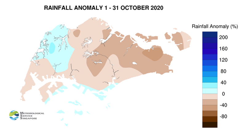
9     In October 2020, rainfall was below average over most parts of the island. Choa Chu Kang recorded the highest rainfall anomaly of 28% above average, while Changi recorded rainfall anomaly of 48% below average.


CLIMATE STATION STATISTICS

Long-term Statistics for November
(Climatological reference period: 1981 – 2010)

Average daily maximum temperature 31.1 °C
Average daily minimum temperature 24.3 °C
Average monthly temperature 27 °C
Average rainfall 258.5 mm
Average number of rain days 18


Historical Extremes for November
(Rainfall since 1869 and temperature since 1929)

Highest monthly mean daily maximum temperature: 32.1 °C (2015)
Lowest monthly mean daily minimum temperature: 22.4 °C (1933)
Highest monthly rainfall ever recorded: 512.5 mm (1874)
Lowest monthly rainfall ever recorded: 53.5 mm (1981)