Monthly Archives: August 2019

August 30, 2019

Expect Another Dry and Warm Fortnight

August 2019 likely the driest and warmest August on record

Dry and warm conditions on most days in Sep19. Thundery showers likely between late morning and early afternoon (4-5 days), and in the morning (1-2 days). Few warm days with temp around 35°C.

Fortnightly Weather Outlook for 30 August – 15 September 2019


Singapore, 30 August 2019 – The prevailing Southwest Monsoon conditions in the region are forecast to persist in the first fortnight of September 2019.  During the period, the low level winds are forecast to blow mostly from the southeast or southwest, and may on brief occasions, shift to blow from the west.

2          During the fortnight, the monsoon rain band is forecast to remain over the northern Southeast Asia region, away from Singapore. Under the influence of cooler sea surface temperatures over the tropical eastern Indian Ocean, dry weather is forecast to prevail over Singapore and the surrounding region in the first fortnight of September 2019. However, localised short-duration thundery showers can still be expected on four or five days between the late morning and early afternoon. In addition, Sumatra squalls are forecast to bring thundery showers and gusty winds on one or two mornings. The rainfall in the first fortnight of September is likely to be significantly below normal.

3          The first fortnight of September 2019 is expected to be as warm as the last month. On most days, the daily temperature is forecast to range between 26°C and 34°C, with highs of around 35°C on a few days. Warm nights with daily minimum temperatures above 26°C are expected on some days, reaching around 28°C in the southern and eastern coastal areas when prevailing winds blowing from the southeast bring in warm and humid air from the surrounding seas.

4          The weather in the surrounding region is also forecast to be dry in the coming weeks. Hotspots with smoke plumes continue to be observed in parts of Sumatra and Kalimantan. Depending on the direction of the prevailing winds and the proximity and extent of the fires, Singapore may experience occasional haze.

5         For updates of the daily weather and haze situation, please visit the MSS website (https://www.weather.gov.sg), NEA website (www.nea.gov.sg), or download the myENV app, MSS’ Weather@SG app, and the haze microsite (www.haze.gov.sg).


REVIEW (1 – 29 August 2019)

6          In August 2019, Southwest Monsoon conditions continued to persist with the low level winds blowing from the southeast or southwest.

7          The weather over Singapore and the surrounding region has been dry since late July 2019. Between 31 July and 16 August 2019, Singapore experienced a dry spell[1] of 17  consecutive days. The dry spell eased on 17 August 2019 when showers fell over many parts of the island that day. The highest rainfall recorded on 17 August 2019 was 13.0 mm around the city area. The extended dry weather can be attributed to an intrusion of dry air from high pressure systems over northern Australia coupled with suppressed raincloud formation due to cooler sea surface temperatures over the tropical eastern Indian Ocean (positive phase of Indian Ocean Dipole (IOD)[2]).

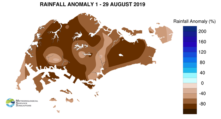
8          For the rest of August 2019, it was dry and warm on most days with a few days of thundery showers which brought some welcome relief from the hot and humid conditions. On 26 August 2019, strong solar heating of land areas coupled with large-scale wind convergence brought widespread moderate to heavy thundery showers over many parts of the island. The highest daily total rainfall recorded that day was 78.4 mm at Yishun. At the climate station in Changi, the total rainfall recorded for August 2019 was 11.8 mm (as of 29 August 2019), lower than the August record low rainfall of 18.0 mm in 1888. August 2019 is thus on track to be the driest August in Singapore since rainfall records began in 1869.

9          August 2019 was also a warm month, with daily maximum temperatures reaching at least 34°C on 13 days (as at 29 August 2019). The highest temperature of 34.8°C was recorded at Marina Barrage on 23 August 2019. The nights were generally warm with daily minimum temperatures above 26°C recorded over most parts of Singapore. There were a few nights in the southern and eastern coastal areas of the island where the minimum temperature was around 28°C.

10        At the climate station in Changi, the mean monthly temperature for the month is 29.1°C (as at 29 August 2019). This is 0.2°C above the highest ever mean monthly temperature for August, recorded in 2016. August 2019 is thus likely to be the warmest ever August in Singapore since temperature records started in 1929. For the month to date, the average minimum temperature for August 2019 was 27.1°C, 0.9°C above the August record high temperature of 26.2°C in 2016.

11        Significantly well-below-average rainfall was recorded across the island in August 2019. The lowest anomaly of 98% below-average was recorded at Paya Lebar.

[1] A dry spell is defined as a period of at least 15 consecutive days with daily total rainfall of less than 1.0 mm, averaged over rainfall stations with long-term records across the island.

[2] The Indian Ocean Dipole (IOD) refers to the sustained change to the difference between sea surface temperatures (SSTs) of the tropical western and eastern Indian Ocean. The IOD varies between three phases – positive, negative and neutral. A positive (negative) phase occurs when cooler (warmer) SSTs develop in the eastern Indian Ocean, resulting in below (above) normal rainfall in the eastern Indian Ocean and the surrounding region. More information on the IOD can be found at https://www.weather.gov.sg/LEARN_climate/.


CLIMATE STATION STATISTICS

Long-term Statistics for September
(Climatological reference period: 1981 – 2010)

Average daily maximum temperature 31.4 °C
Average daily minimum temperature 24.8 °C
Average monthly temperature 27.6 °C
Average rainfall 156.5 mm
Average number of rain days 13


Historical Extremes for September
(Rainfall since 1869 and temperature since 1929)

Highest monthly mean daily maximum temperature: 32.2 °C (1997)
Lowest monthly mean daily minimum temperature: 22.4 °C (1930)
Highest monthly rainfall ever recorded: 440.4 mm (1988)
Lowest monthly rainfall ever recorded: 23.7 mm (1994)

August 16, 2019

Current Dry Spell to Ease with Thundery Showers in Coming Fortnight
Singapore has been experiencing a dry spell since 31 Jul19. Dry and warm conditions to persist for the rest of Aug19. Expect short-duration thundery showers on 4-5 days in late morning & early afternoon. Temp 26°C to 34°C, with a high of around 35°C on few days.

Fortnightly Weather Outlook for 16 – 31 August 2019


Singapore, 16 August 2019 – The prevailing Southwest Monsoon conditions are forecast to persist over Singapore and the surrounding region for the rest of August 2019, and extend into October 2019. During this period, the prevailing winds are forecast to blow mostly from the southeast or southwest.

2          In the second fortnight of August 2019, dry conditions are forecast on most days as dry air from high pressure systems over northern Australia extends to the equatorial region. Singapore has been experiencing a dry spell [1] since 31 July 2019. With thundery showers expected in the late morning and early afternoon on four or five days toward the last week of August 2019, the showers will bring some respite to the current dry spell. On some days, breezy conditions can be expected due to the occasional strengthening of winds over the equatorial region. Rainfall for the month is expected to be significantly below normal.

3         The rest of August 2019 is expected to be warm. On most days, the daily temperature is forecast to range between 26°C and 34°C, with highs of around 35°C on a few days. The minimum temperature on some nights can hover around 28°C, when prevailing winds blowing from the southeast bring in warm and humid air from the surrounding seas.

4         The dry weather in the surrounding region is forecast to persist. Hotspots with smoke plumes continue to be observed in various parts of Sumatra and Kalimantan. Depending on the direction of the prevailing winds and location of the fires, Singapore may experience occasional haze.

5         For updates of the daily weather forecast, please visit our MSS website (https://www.weather.gov.sg), NEA website (www.nea.gov.sg), or download the myENV app, or the MSS’ Weather@SG app.


REVIEW (1 – 15 August 2019)

6          During the first fortnight of August 2019, Southwest Monsoon conditions prevailed with the low level winds blowing from the southeast or southwest.

7          The dry weather prevailing in Singapore and the surrounding region since late July 2019 persisted in the first half of August 2019. Singapore experienced a dry spell [1] of 16  consecutive days between 31 July and 15 August 2019. While brief localised showers fell on some days, most parts of Singapore were dry with about 90% of all stations island-wide recording daily rainfall below 0.2 mm. The last recorded dry spell in Singapore lasted 27 days from 17 February to 15 March 2014. The extended dry weather can be attributed to an intrusion of dry air from northern Australia coupled with suppressed raincloud formation due to cooler sea surface temperatures over the tropical eastern Indian Ocean (positive phase of Indian Ocean Dipole (IOD)[2]).

8          The dry weather also contributed to a very warm first half of August 2019, with the daily maximum temperature ranging between 31.9°C and 34.5°C. The highest temperature of 34.5°C was recorded at Marina Barrage on 13 August 2019. The nights were generally warm with daily minimum temperatures above 26°C recorded over most parts of Singapore. There were a few nights where the temperature remained around 28°C in the southern and eastern coastal areas of Singapore.

9          In the first fortnight of August 2019, significantly below-average rainfall was recorded at all stations across the island. The rainfall anomaly was close to 100% below-average for many parts of Singapore.

[1] A dry spell is defined as a period of at least 15 consecutive days with daily total rainfall of less than 1.0 mm, averaged over rainfall stations with long-term records across the island.

[2] The Indian Ocean Dipole (IOD) refers to the sustained change to the difference between sea surface temperatures (SSTs) of the tropical western and eastern Indian Ocean. The IOD varies between three phases – positive, negative and neutral. A positive (negative) phase occurs when cooler (warmer) SSTs develop in the eastern Indian Ocean, resulting in below (above) normal rainfall in the eastern Indian Ocean and the surrounding region. More information on the IOD can be found at https://www.weather.gov.sg/LEARN_climate/.


CLIMATE STATION STATISTICS

Long-term Statistics for August
(Climatological reference period: 1981 – 2010)

Average daily maximum temperature 31.4 °C
Average daily minimum temperature 25.0 °C
Average monthly temperature 27.9 °C
Average rainfall 148.9 mm
Average number of rain days 14


Historical Extremes for August
(Rainfall since 1869 and temperature since 1929)

Highest monthly mean daily maximum temperature: 32.6 °C (1997)
Lowest monthly mean daily minimum temperature: 23.0 °C (1962)
Highest monthly rainfall ever recorded: 526.8 mm (1878)
Lowest monthly rainfall ever recorded: 18.0 mm (1888)

August 3, 2019

Increased Risk of Transboundary Haze with Drier Weather in Coming Months

Singapore, 2 August 2019 – The National Environment Agency’s (NEA) Meteorological Service Singapore (MSS) is forecasting drier-than-normal weather conditions in Singapore and the surrounding region, including Sumatra and Kalimantan, in the coming weeks. In recent days, persistent hotspot activities with smoke plumes have been observed in Riau and Jambi provinces in Sumatra and southern parts of Kalimantan. These conditions can lead to an escalation of hotspot activities and an increase in the risk of transboundary haze occurrence in Singapore and the surrounding region.

2      Since early July 2019, dry weather has been persisting over southern Sumatra and Kalimantan. Drier weather can be expected in the next three months (August to October), with monthly rainfall of up to 60% below average.

3     Singapore has likewise been experiencing dry and warm weather in recent weeks. The total rainfall recorded for July 2019 at the climate station in Changi is 92% below the long term average, breaking the record set in 1997 for the driest July in Singapore. July 2019 is also Singapore’s second warmest July on record, with an average temperature of 29.0°C.

Impact of the Indian Ocean Dipole

4     Neutral conditions (neither El Nino nor La Nina) currently prevail in the tropical Pacific Ocean, and are forecast to persist for the rest of the year. A key climate driver influencing the rainfall over Singapore and the surrounding region over the next few months is the Indian Ocean Dipole (IOD), which refers to the sustained change to the difference between sea surface temperatures (SSTs) of the tropical western and eastern Indian Ocean. The IOD varies between three phases – positive, negative and neutral. A positive (negative) phase occurs when cooler (warmer) SSTs develop in the eastern Indian Ocean, resulting in below (above) normal rainfall in the eastern Indian Ocean and the surrounding region. Each phase occurs every three to five years on average and typically lasts about six months.

5     The IOD is currently in its positive phase, which leads to drier weather over the areas adjacent to the eastern Indian Ocean, including Sumatra, Malaysia and Singapore. Major climate centres are predicting that the positive phase of the IOD is expected to persist over the coming months.

Risk of Transboundary Haze

6     Singapore may experience occasional occurrences of transboundary haze during the next few weeks to months. The likelihood of haze affecting Singapore is dependent on factors such as the proximity and extent of the fires, the direction and strength of the prevailing winds, and the incidence of rain.

7     MSS will continue to closely monitor the regional weather and haze situation, and provide updates when necessary. Updates on haze information are available on the MSS website at https://www.weather.gov.sg/warning-haze-satellite-image/.

August 1, 2019

Dry and Warm Conditions to Persist into August 2019 Following Record Dry July 2019
Jul’19-driest July on record. Dry and warm conditions to persist into Aug with an occasional breeze on some days. Short-duration thundery showers on 4-5 days (late morning & early afternoon), Sumatra squalls on 1-2 mornings. Temp 26°C to 33°C, with a high exceeding 34°C on some days. 

Fortnightly Weather Outlook for 1 – 15 August 2019


Singapore, 1 August 2019 – The prevailing Southwest Monsoon conditions in the region are forecast to persist in the first fortnight of August 2019 and last till October 2019.  During the period, the low level winds are expected to blow from the southeast or south.

2          During the fortnight, the monsoon rain band is forecast to maintain its position over the northern Southeast Asia region. Furthermore, with the occasional intrusion of dry air from high pressure systems in the southern hemisphere, the weather during the fortnight is forecast to be drier than that in the second half of July 2019. The prevailing winds extending from these high pressure systems are expected to strengthen around the equatorial region. This can bring occasional breezy conditions on some days to Singapore and the surrounding vicinity.

3          Despite the drier conditions in the coming fortnight, localised short-duration thundery showers can still be expected on four or five days in the late morning and early afternoon. In addition, Sumatra squalls are forecast to bring thundery showers and gusty winds in the morning on one or two days. The rainfall in the coming fortnight is likely to be well-below normal.

4          The first fortnight of August 2019 is expected to be as warm as the last fortnight of July 2019. The daily temperature over Singapore is forecast to range between 26°C and 33°C, and could exceed 34°C on some days. In addition, on some nights, warm and humid conditions with night-time minimum temperatures of around 28°C can be expected when prevailing winds blowing from the southeast bring in warm air from the surrounding seas.

5          The surrounding region is also expected to experience dry weather in the coming weeks.  Hotspots with smoke plumes have been observed in central Sumatra and southern Kalimantan in recent days. Depending on the direction of the prevailing winds and location of the fires, Singapore may experience occasional haze in the first fortnight of August 2019.

6         For updates of the daily weather forecast, please visit our MSS website (https://www.weather.gov.sg), NEA website (www.nea.gov.sg), or download the myENV app, or the MSS’ Weather@SG app.


REVIEW (1 – 31 July 2019)

7          In July 2019, Southwest Monsoon conditions continued to persist with the low level winds blowing from the southeast or southwest.

8          In the first half of July 2019, short-duration thundery showers fell in the late morning and afternoon on most days due to strong solar heating of land areas and convergence of winds in the surrounding vicinity. The highest daily total rainfall for July 2019 was 51.6mm recorded at Mandai on 8 July 2019. The second half of July 2019 was mostly dry and warm over Singapore and the surrounding region, partly due to a mass of dry air blowing from the southern hemisphere toward the equatorial region. At the Changi climate station, the total rainfall recorded for July 2019 was 12.2mm. This makes July 2019 the driest July in Singapore since rainfall records began in 1869. The previous record was 18.6mm set in July 1997.

9          July 2019 was also a warm month. The daily maximum temperature in July 2019 ranged between 28.7°C and 34.5°C. There were also a few warm nights where the night-time temperature was around 28°C mostly over the southern and eastern parts of the island. At the climate station in Changi, the monthly average temperature for July 2019 was 29.0°C. This ranks July 2019 as the second warmest July on record since temperature records began in 1929, after July 2015 with an average temperature of 29.1°C. The average minimum temperature for July 2019 was 26.9°C, surpassing the July record high temperature of 26.7°C in 2015.

10          Well-below-average rainfall was recorded across the island in July 2019. The lowest anomaly of 92% below-average was recorded at Changi.

CLIMATE STATION STATISTICS

Long-term Statistics for August
(Climatological reference period: 1981 – 2010)

Average daily maximum temperature 31.4 °C
Average daily minimum temperature 25.0 °C
Average monthly temperature 27.9 °C
Average rainfall 148.9 mm
Average number of rain days 14


Historical Extremes for August
(Rainfall since 1869 and temperature since 1929)

Highest monthly mean daily maximum temperature: 32.6 °C (1997)
Lowest monthly mean daily minimum temperature: 23.0 °C (1962)
Highest monthly rainfall ever recorded: 526.8 mm (1878)
Lowest monthly rainfall ever recorded: 18.0 mm (1888)