The first fortnight of February 2018 expected to be dry and warm. Short-duration thundery showers expected in the afternoon on some days.
Singapore, 1 February 2018 – The prevailing Northeast Monsoon will continue into the first half of February 2018. For the next fortnight, dry, warm and occasionally windy conditions are expected over Singapore as the region enters the dry phase of the Northeast Monsoon season. During this period, the low level winds are forecast to blow predominantly from the northeast or northwest.
2 Compared with the very wet weather experienced in January 2018, the first half of February 2018 is forecast to be relatively dry with some warm days. Short-duration thundery showers are expected in the afternoon on three to five days. In addition, a weak monsoon surge [1] could affect the South China Sea and the surrounding region in the early part of the month. The surge is expected to bring windy conditions with passing showers and cooler temperatures to Singapore on a few days. The rainfall for the first fortnight of February 2018 is expected to be below normal.
3 In the first half of February 2018, the daily temperatures are forecast to range between 24°C and 33°C, and could reach a high of around 34°C on a few days. Cooler temperatures can be expected with daily minimum temperatures ranging between 23°C and 24°C on windy or rainy days.
4 For updates of the daily weather forecast, please visit the MSS website (https://www.weather.gov.sg), NEA website (www.nea.gov.sg), or download the myENV app, MSS’ Weather@SG app.
REVIEW (1 – 31 January 2018)
5 January 2018 was an eventful month for Singapore weather. The first week of January 2018 saw moderate to heavy thundery showers from three different weather systems – localised thunderstorms, Sumatra squalls and monsoon surges. In the last week of the month, hailstones and a waterspout were observed on 30 and 31 January respectively.
6 On most days of the month, thundery showers fell over Singapore in the afternoon and evening. On the morning of 8 January, a Sumatra squall brought widespread thundery showers to the island with the eastern parts of Singapore receiving the heaviest rainfall. The heavy rain resulted in flash floods in several places, and the highest total daily rainfall recorded was 131.8mm in the Paya Lebar area.
7 In the first half of January 2018, there were two occurrences of monsoon surge. The monsoon surge on 1 January was the tail-end of a 3-day monsoon surge episode that started on 30 December 2017. The second monsoon surge episode from 10 to 14 January brought five consecutive days of cool weather, with daily minimum temperatures dipping to as low as 21.2°C; this was the longest cool spell in Singapore in the last ten years. Both monsoon surge episodes brought overcast skies, windy conditions and widespread rain to Singapore and the surrounding region.
8 On 30 January 2018, intense thunderstorms brought heavy rainfall with strong winds over many areas of the island. Hailstones were observed in some parts of northern Singapore including Seletar and Yishun. The following day, another intense thunderstorm event brought strong winds and heavy rainfall to the eastern parts of Singapore. A waterspout also developed over the sea areas off the east coast of Singapore.
9 In January 2018, the daily maximum temperature ranged between 24.3°C and 34.9°C. and the daily minimum temperature was between 21.2°C and 24.1°C. The lowest temperature recorded was 21.2°C at Admiralty and Jurong West on 14 January 2018 during a monsoon surge. At the Changi climate station, the mean monthly temperature of 26.2°C for January 2018 is 0.3°C below the long-term mean for January.
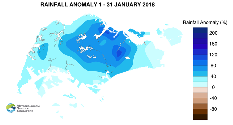
10 Singapore received well above normal rainfall in January 2018. The highest rainfall of 502.4mm (119% above average) was recorded at Paya Lebar. Rainfall was lowest around the Changi area where 272.6mm (16% above average) was recorded.
[1] A monsoon surge refers to the strengthening of northeasterly winds blowing from a strong high-pressure system over the northern Asian continent toward the South China Sea, bringing periods of prolonged widespread rain and windy conditions to the surrounding region including Singapore and Peninsular Malaysia. (Further information is available at https://www.weather.gov.sg/learn_weather_systems/).
CLIMATE STATION STATISTICS FOR FEBRUARY (Climatological reference period: 1981 – 2010)
| Mean daily maximum temperature |
31.7 °C |
| Mean daily minimum temperature |
24.3 °C |
| Mean monthly temperature |
27.1 °C |
| Mean rainfall for the month |
112.8 mm |
| Mean number of rain days |
8 |
| Highest monthly mean daily maximum temperature |
33.5 °C (2010) |
| Lowest monthly mean daily minimum temperature |
23.0 °C (1982) |
| Highest monthly rainfall |
470.4 mm (1984) |
| Lowest monthly rainfall |
6.3 mm (2010) |