Monthly Archives: January 2018

January 16, 2018

Less Wet Weather Expected in The Next Fortnight

Short-duration thundery showers expected between the afternoon and evening on most days in the next fortnight. Rainfall expected to be well-above normal in January 2018.

Singapore, 16 January 2018 – The prevailing Northeast Monsoon season is forecast to continue into the second fortnight of 2018. For the next two weeks, the low level winds over Singapore and the surrounding region are forecast to blow mostly from the northeast or northwest.

2           The second fortnight of January 2018 is not expected to be as wet as the first fortnight of the month. In the second half of the month, five to seven days of short-duration thundery showers are expected in the afternoon, and could extend into the evening on a few days. The passage of Sumatra squalls is expected to bring widespread thundery showers coupled with occasional gusty winds over Singapore between the predawn and early morning on one or two days. Overall, the rainfall for January 2018 is expected to be well above normal.

3            During the second fortnight of January 2018, the daily temperatures are forecast to range between 24°C and 32°C. On some rainy days, cooler temperatures can be expected with the daily maximum temperature ranging between 27°C and 29°C, and the daily minimum temperature ranging between 23°C and 24°C.

4          For updates of the daily weather forecast, please visit the MSS website (https://www.weather.gov.sg), NEA website (www.nea.gov.sg), or download the myENV app, MSS’ Weather@SG app.

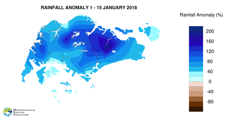
REVIEW (1 – 16 January 2018)

5          Northeast Monsoon conditions prevailed over Singapore and the surrounding region in the first two weeks of 2018. The low level winds during this first fortnight were predominantly from the northeast or northwest, and rain fell over the island almost every day.

6          A monsoon surge affected the South China Sea and the surrounding region over three days from 30 December 2017 to 1 January 2018. On 1 January 2018, as the surge weakened, the day was cloudy and occasionally windy, accompanied by periods of light to moderate rain. It was also cool with daily temperatures ranging from 22.7°C to 27.3°C. On several days in the first week of the year, moderate to heavy thundery showers fell in the afternoon and evening due to strong solar heating of land areas coupled with convergence of winds. On 8 January, a temporary change in the winds to blow from the southwest led to the passage of a Sumatra squall in the predawn hours and morning. The squall brought widespread thundery showers over the island, with the rainfall station at Paya Lebar recording 131.8mm of rain in a day. This was the highest total daily rainfall recorded in the first fortnight of January 2018.

7          In the second week of January 2018, another monsoon surge affected the South China Sea and the region between 10 and 14 January. The surge brought overcast skies, windy conditions and widespread rain to Singapore for five consecutive days. Over this period, the daily maximum temperature was between 24.3°C and 28.5°C while the daily minimum temperature dipped to a low of between 21.2°C and 22.4°C.

8          In the first fortnight of 2018, the daily maximum temperature ranged between 24.3°C and 33.2°C, and the daily minimum temperatures ranged between 21.2°C and 23.7°C. The lowest temperature of 21.2°C was recorded on 14 January 2018 at Admiralty and Jurong West.

9          Singapore received significantly above normal rainfall in the first fortnight of January 2018. The highest rainfall of 339.4mm (206% above average) was recorded at Paya Lebar. Rainfall was lowest around the Bukit Panjang area where 162.5mm (44% above average) was recorded.

FortnightRain_Anomaly_201801a

CLIMATE STATION STATISTICS FOR JANUARY (Climatological reference period: 1981 – 2010)

Mean daily maximum temperature 30.4 °C
Mean daily minimum temperature 23.9 °C
Mean monthly temperature 26.5 °C
Mean rainfall for the month 234.6 mm
Mean number of rain days 13
Highest monthly mean daily maximum temperature 31.8 °C (1998)
Lowest monthly mean daily minimum temperature 22.6 °C (1981, 1982)
Highest monthly rainfall 600.9 mm (2004)
Lowest monthly rainfall 15.4 mm (1997)

January 11, 2018

MSS Releases Review Of 2017’s Weather And Climate For Singapore

2017 is the warmest year on record not influenced by an El Niño event 

Singapore, 11 January 2018 – A review of the weather and climate in 2017 was released today by the Meteorological Service Singapore (MSS). It summarises the main climatic features and notable weather events that affected Singapore and is a prelude to the comprehensive Annual Climate Assessment Report which will be released on World Meteorological Day in March 2018. The review is available on MSS’ website at https://www.weather.gov.sg (refer to Annex A for an infographic on Singapore’s Climate in 2017).

2          2017 is the warmest year on record that was not influenced by an El Niño event, indicative of the long-term temperature rise that Singapore has been experiencing due to factors such as global warming and urbanisation. After two successive record warm years in 2015 and 2016, the 2017 mean annual temperature at 27.7°C has returned to a level closer to the 1981-2010 long-term average. This is still 0.2°C warmer than the long-term average and the joint 12th warmest year on record since Singapore temperature records started in 1929.

Neutral El Niño Southern Oscillation

3          The El Niño Southern Oscillation[1] (ENSO), a naturally occurring phenomena and a major contributor to year-to-year rainfall and temperature variations over Singapore and Southeast Asia, was neutral throughout 2017 (except in November and December where it reached borderline La Niña values). Given the influence ENSO can have on temperatures, it is not surprising that following 2015’s large El Niño event which contributed to 2015 and 2016 being successive record warm years, no temperature record was broken in 2017.

4          There was a mixture of above and below normal level rainfall for the individual months in 2017, but overall the annual total rainfall was close to normal. This is more likely to be observed during a largely neutral ENSO year. The annual total rainfall of 2,045.6mm recorded was around 6 per cent below the long-term average of 2,165.9mm.

Notable weather events in 2017           

5          While 2017 was not an El Niño year, some very warm days were experienced in certain months. October 2017 in particular was warm, with temperatures soaring to above 35°C on some days. Based on the Changi climate station, the hottest day in 2017 was on 18 October 2017 with a high of 34.6°C. The normally cool months of January and December also saw warmer than usual temperatures on some days.

6          Heavy rains from intense thunderstorms caused several incidents of flash floods during the year. There were also occasional incidents of fallen trees and branches due to strong wind gusts from Sumatra squalls, and there was a high frequency of these squalls in 2017. On 18 June 2017, a waterspout associated with thunderstorm clouds was observed off Singapore’s southern coast.

7          Northeast Monsoon rains contributed to a wet February and December in 2017. The 15 rain days recorded in February 2017 was almost twice the long-term average for February, a normally dry month. The year ended on a wet note as the island experienced widespread intermittent rain from a monsoon surge and a nearby vortex in the South China Sea. High rainfall on the last two days of December 2017 raised the month’s total rainfall to 371.2mm (17 per cent above the long-term average), making December the wettest month of 2017.

[1] El Niño Southern Oscillation (ENSO) is a recurring climate pattern caused by interactions between the atmosphere and the ocean in the tropical Pacific. During El Niño, the central-eastern equatorial Pacific Ocean is warmer than usual, leading to drier and warmer conditions especially during the June to October period over Southeast Asia. During La Niña, the central-eastern equatorial Pacific is cooler than average and the atmosphere over the Southeast Asia region is typically wetter than average. El Niño or La Niña events occur on average once every three to five years.

~~ End ~~

For more information, please contact us at 1800-CALL NEA (1800-2255 632) or submit your enquiries electronically via the Online Feedback Form or myENV mobile application.

Annex A 

Singapore Climate 2017

January 2, 2018

First Two Weeks of 2018 Expected to be Wet

Wet weather conditions expected in the first fortnight of 2018. Short-duration thundery showers between the afternoon and evening on some days, and occasionally windy conditions with widespread moderate to heavy rain and cool temperatures on a few days due to a monsoon surge.

Singapore, 2 January 2018 – The prevailing Northeast Monsoon season is forecast to continue into the first fortnight of 2018. During the next two weeks, the low level winds over Singapore and the surrounding vicinity are expected to blow mainly from the northeast or northwest.

2           The wet weather conditions experienced in Singapore in the last few days of December 2017 are expected to continue in the first half of January 2018. During the two weeks, moderate to heavy thundery showers are forecast in the afternoon on six to eight days. On a few of these days, the thundery showers could extend into the early evening. A monsoon surge[1] could affect the South China Sea and the surrounding region in the latter half of the fortnight. The surge is expected to bring a few days of occasionally windy conditions with widespread moderate to heavy rain and cooler temperatures to Singapore. Rainfall for the first half of January 2018 is expected to be above normal.

3           During the first fortnight of January 2018, slightly cooler night-time minimum temperatures of 23°C to 24°C can be expected. The maximum day-time temperatures are likely to range between 31°C and 33°C.

4          For updates of the daily weather forecast, please visit the MSS website (https://www.weather.gov.sg), NEA website (www.nea.gov.sg), or download the myENV app, MSS’ Weather@SG app.

REVIEW (1 – 31 December 2017)

5          Northeast Monsoon conditions prevailed over Singapore and the surrounding region in December 2017, and the low level winds were predominantly from the northeast or northwest.

6          In early December 2017, strong solar heating of land areas coupled with convergence of winds brought moderate to heavy thundery showers over Singapore in the afternoon and early evening on several days. In the third week of the month, the presence of two consecutive tropical storms in the South China Sea had an influence on the weather and wind conditions in the surrounding region. Winds over Singapore shifted to blow from the southwest and the passage of Sumatra squalls across the island brought widespread thundery showers in the predawn hours and morning on a few days.  In the last week of the month, a monsoon surge on 30-31 December 2017 brought overcast and occasionally windy conditions with periods of widespread moderate to heavy rain to Singapore. The highest total daily rainfall recorded in December 2017 was 149.6mm around the Buona Vista area on 31 December 2017.

7          In December 2017, the daily maximum temperatures ranged between 26.8°C and 35.1°C, and the daily minimum temperatures ranged between 22.3°C and 25.6°C. At the climate station, the daily maximum temperature of 33.5°C recorded on 1 December 2017 is among the top five daily maximum temperature on record for December since 1929. In addition, the mean monthly temperature of 27.1°C for December 2017 is 0.7°C above the long-term mean for December.

8          About half of Singapore received above normal rainfall in December 2017. The highest rainfall of 502.4mm (65% above average) was recorded around the Seletar area. Rainfall was lowest around the Bukit Panjang area where 211.6mm (28% below average) was recorded.

[1] A monsoon surge refers to the strengthening of northeasterly winds blowing from a strong high-pressure system over the northern Asian continent toward the South China Sea, bringing periods of prolonged widespread rain and windy conditions to the surrounding region including Singapore and Peninsular Malaysia. (Further information is available at  https://www.weather.gov.sg/learn_weather_systems/)

FortnightRain_Anomaly_201712b_31 Dec 2017

CLIMATE STATION STATISTICS FOR JANUARY (Climatological reference period: 1981 – 2010)

Mean daily maximum temperature 30.4 °C
Mean daily minimum temperature 23.9 °C
Mean monthly temperature 26.5 °C
Mean rainfall for the month 234.6 mm
Mean number of rain days 13
Highest monthly mean daily maximum temperature 31.8 °C (1998)
Lowest monthly mean daily minimum temperature 22.6 °C (1981, 1982)
Highest monthly rainfall 600.9 mm (2004)
Lowest monthly rainfall 15.4 mm (1997)