Monthly Archives: March 2017

March 31, 2017

Singapore Experiencing Inter-Monsoon Conditions

Wet and warm weather expected in the first fortnight of April 2017

Singapore, 31 March 2017 –  Inter-monsoon conditions characterised by low level winds that are light and variable in direction set in over the region in the last week of March 2017. The Inter-monsoon period is forecast to persist until end May 2017.

2          During the inter-monsoon period, warm weather and thundery showers in the afternoon and early evening are common. The predominantly light and variable winds during this period, coupled with strong daytime heating of land areas, are conducive for the development of localised and intense thunderstorms. In addition, the incidence of lightning activity during the inter-monsoon months is higher than other times of the year.

3          The first fortnight of April 2017 is forecast to be wet with short-duration moderate to heavy thundery showers mostly in the afternoon on six to seven days, and could extend into evening on a few of these days. In addition, a temporary shift in the winds to blow from the southwest or west could lead to the development of Sumatra squalls to the west of Singapore, and bring widespread thundery showers accompanied by gusty winds to Singapore on two or three days in the predawn and early morning. Overall, rainfall in the first two weeks of April is expected to be slightly above normal.

4          Climatologically, April is one of the warmest months of the year. For the first half of April 2017, the temperature is forecast to range between 24°C and 34°C. A few warm days can be expected in the middle of the period where the daily maximum temperatures could reach a high of around 35°C.

5          For updates of the daily weather forecast, please visit our MSS website (https://www.weather.gov.sg), NEA website (www.nea.gov.sg), or download the myENV app, or the MSS’ Weather@SG app.

Review: 1 – 30 March 2017

6          In the second half of March 2017, the prevailing northeasterly winds gradually weakened to become light and variable in direction as the region transitioned to the inter-monsoon period.

7          In March 2017, Singapore experienced thundery showers mostly in the afternoon. The showers were heaviest on the afternoon of 25 March 2017 over northern Singapore, with the highest daily total rainfall of 110.4mm recorded in the Mandai area. The heavy thundery showers were induced by strong heating of land areas coupled with convergence of winds in the surrounding vicinity.

8          The mean temperature for March 2017 to date was 27.4°C which is 0.1°C lower than the long-term mean temperature. During the month, there were a few warm days where the highest daily maximum temperature ranged between 35.0°C and 35.7°C. The daily minimum temperature ranged between 22.1°C and 26.5°C.

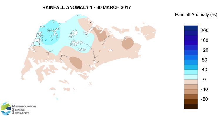
9          More than half of Singapore received below normal rainfall in March 2017. The lowest rainfall of 139.8mm (36% below average) was recorded around Queenstown area. Rainfall was highest around the Choa Chu Kang area where 320.8mm (41% above average) was recorded.

FortnightRain_Anomaly_201703b

CLIMATE STATION STATISTICS FOR APRIL (Climatological reference period: 1981 – 2010)

Mean daily maximum temperature 32.3 °C
Mean daily minimum temperature 25.0 °C
Mean monthly temperature 28.0 °C
Mean rainfall for the month 154.8 mm
Mean number of rain days 14
Highest monthly mean daily maximum temperature 33.9 °C (1983)
Lowest monthly mean daily minimum temperature 23.9 °C (1982)
Highest monthly rainfall 311.6 mm (2000)
Lowest monthly rainfall 43.1 mm (1983)

March 16, 2017

Inter-monsoon Conditions to Set in By End March 2017

Warm conditions expected on a few days

Singapore, 16 March 2017 – The prevailing Northeast Monsoon conditions are expected to weaken and gradually transition to inter-monsoon conditions around the last week of March 2017. The low level winds are forecast to blow from the northeast or northwest in the early part of the fortnight and become light and variable in direction with the onset of the inter-monsoon period in the later part of the month.

2          The inter-monsoon period is expected to prevail into April and May 2017. This period is characterised by warm weather and thunderstorms developing mainly in the afternoon and early evening. Light wind conditions are common during the inter-monsoon period, during which particulate matter in the atmosphere take a longer time to disperse. This may occasionally produce the appearance of slightly hazy skies over parts of Singapore on some days.

3          In the second half of March 2017, short-duration thundery showers are expected on five to seven days, mostly in the afternoon, and could extend into the evening on a few days. The thunderstorms can be heavy on some days because of strong convection due to daytime heating of land areas. In addition, widespread thundery showers accompanied by gusty winds can be expected in the morning on one or two days during the period. Overall, the rainfall for March 2017 is likely to be slightly below normal.

4          In the next fortnight, relatively warm temperatures of between 34°C and 35°C can be expected on a few days when there is strong solar heating and the winds are light. On most days, the daily maximum temperature is forecast to range between 33°C and 34°C.

5          For updates of the daily weather forecast, please visit our MSS website (https://www.weather.gov.sg), NEA website (www.nea.gov.sg), or download the myENV app, or the MSS’ Weather@SG app.

Review: 1 – 15 March 2017

6          Northeast Monsoon conditions prevailed over the region in the first fortnight of March 2017, with the low level winds blowing mainly from the northeast or northwest.

7          During the first half of March 2017, Singapore experienced thundery showers mostly in the afternoon. The showers were heaviest on the afternoon of 11 March 2017 over northwestern Singapore. The heavy thundery showers were induced by strong heating of land areas coupled with convergence of winds in the surrounding vicinity. The highest daily total rainfall recorded during the first fortnight of March 2017 was 59.9mm in the Choa Chu Kang area.

8          In the first fortnight of March 2017, the daily maximum temperatures ranged between 27.6°C and 35.7°C, and the daily minimum temperatures ranged between 22.9°C and 25.3°C.

9          About half of Singapore received above normal rainfall in the first half of March 2017. The highest rainfall of 204.6mm (80% above average) was recorded around Choa Chu Kang area. Rainfall was lowest around Changi where 47.4mm (43% below average) was recorded.

FortnightRain_Anomaly_201703a

CLIMATE STATION STATISTICS FOR MARCH (Climatological reference period: 1981 – 2010)

Mean daily maximum temperature 32.0 °C
Mean daily minimum temperature 24.6 °C
Mean monthly temperature 27.5 °C
Mean rainfall for the month 170.3 mm
Mean number of rain days 13
Highest monthly mean daily maximum temperature 34.1 °C (1998)
Lowest monthlymean daily minimum temperature 23.7 °C (1982)
Highest monthly rainfall 361.3 mm (1984)
Lowest monthly rainfall 34.3 mm (1997)


March 1, 2017

First Week Of March 2017 Expected To Be Wet

Drier conditions in the second week

Singapore, 1 March 2017 – The prevailing Northeast Monsoon conditions over the region are forecast to persist into the first fortnight of March 2017. During this period, the low level winds are expected to blow from the north or northeast.

2          With the presence of the monsoon rain band located around the equatorial region, including over Singapore and the surrounding vicinity in the first week of March 2017, wetter weather conditions are expected during this period compared to the second week of the fortnight. Thundery showers, which can be heavy at times, are expected mostly in the afternoon on most days in the first week of March 2017.  In the latter half of the fortnight, most of the convective activity in the region are likely to be around areas further east of Singapore, and drier weather is expected for Singapore and the surrounding vicinity. Localised short-duration thundery showers can still be expected in the afternoon on 2-3 days in the second week of the fortnight. Overall, the rainfall for the first half of March 2017 is forecast to be slightly below normal.

3          The daily temperature for the first fortnight of March 2017 is expected to range between 24°C and 33°C on most days, and could reach a high of 34°C with the expected drier weather conditions in the second week of March 2017.

4          For updates of the daily weather forecast, please visit our MSS website (https://www.weather.gov.sg), NEA website (www.nea.gov.sg), or download the myENV app, or the MSS’ Weather@SG app.

Review: 1 – 28 February 2017

5         Northeast Monsoon conditions prevailed over the region in February 2017, and the low level winds during the month blew mostly from the north or northeast.

6         In the first eight days of February 2017, moderate to heavy thundery showers were experienced over the island in the afternoon on most days, and extended into the evening on a few days. The rainfall was heaviest on 8 February 2017 where the highest daily rainfall total recorded was 108.2mm around the Orchard Road area.

7          While February is typically a drier month of the year, February 2017 had been slightly wetter than usual. Apart from the few periods of consecutive days of dry weather conditions, most days in February 2017 were occasionally windy and cool. The lowest daily minimum temperature recorded in February 2017 was 22.5°C on 15 February 2017  when a monsoon surge[1] was affecting the region between 12 and 15 February  2017.  The highest maximum wind gust recorded in February 2017 was 67.4km/h at the Marina South area on 12 February 2017 under the influence of this surge. This is stronger than the highest ever recorded wind gust of 64.4km/h for February at the Changi climate station.

8        In February 2017, the eastern half of Singapore received significantly above normal rainfall. The highest rainfall of 223.2mm (87% above average) was recorded around Pasir Ris area. Rainfall was lowest around Boon Lay area where 99.8mm (32% below average) was recorded.

[1] A monsoon surge refers to a strengthening of winds over the South China Sea, causing extensive rainclouds to form over our surrounding region.

FortnightRain_Anomaly_201702b


CLIMATE STATION STATISTICS FOR MARCH (Climatological reference period: 1981 – 2010)

Mean daily maximum temperature 32.0 °C
Mean daily minimum temperature 24.6 °C
Mean monthly temperature 27.5 °C
Mean rainfall for the month 170.3 mm
Mean number of rain days 13
Highest monthly mean daily maximum temperature 34.1 °C (1998)
Lowest monthlymean daily minimum temperature 23.7 °C (1982)
Highest monthly rainfall 361.3 mm (1984)
Lowest monthly rainfall 34.3 mm (1997)