Monthly Archives: February 2017

February 16, 2017

Some Warm Days in Second Half of February 2017

Short-duration thundery showers on some afternoons

Singapore, 16 February 2017 – The prevailing dry phase of the Northeast Monsoon is expected to persist in the second half of February 2017, and the low level winds are forecast to blow mostly from the northwest or northeast.

2        The monsoon surge [1] in the South China Sea that that has been affecting Singapore and the surrounding region since 12 February 2017 is expected to weaken in the next one or two days. For the rest of the month, short-duration thundery showers are expected in the afternoon on six to eight days, and could extend into the evening on a few days. The showers may be heavy at times, in particular on days when there is strong solar heating of land areas coupled with convergence of winds over the island or in the surrounding vicinity. The rainfall for February 2017 is expected to be slightly above normal.

3        For the rest of February 2017, the daily temperature on most days is expected to range between 24°C and 33°C. Some warm days can be expected in the later part of the fortnight, when the daily maximum temperature could reach a high of 34°C. However, the daily minimum temperature could dip to around 22°C on rainy days.

4        For updates of the daily weather and haze forecast, please visit our MSS website (https://www.weather.gov.sg), NEA website (www.nea.gov.sg), or download the myENV app, MSS’ Weather@SG app.

REVIEW (1 – 15 February 2017)

5        Singapore experienced Northeast Monsoon conditions in the first half of February 2017. During this period, the low level winds over Singapore and the surrounding region were blowing predominantly from the north or northeast.

6        At the start of February 2017, moderate to heavy thundery showers fell over the island on several afternoons, which extended at times into the evening. The showers were heaviest on 8 February 2017 where the highest daily rainfall total recorded was 108.2mm around the Orchard Road area.

7        The wet weather in the early part of the month was followed by a few days of generally dry and occasionally windy conditions. The drier weather experienced on these days was due to a flow of cold dry air from northern continental Asia toward our surrounding region.

8        The brief spell of dry weather in the second week of the month was broken by the occurrence of a monsoon surge between 12 and 15 February 2017. During this period, Singapore experienced windy and cool conditions, and periods of showers on some days. At the Changi climate station, wind gusts of up to 48.2km/h were recorded during the monsoon surge period. In comparison, the highest ever recorded wind gust for February at the Changi climate station is 64.4km/h. The highest maximum wind gust recorded in February 2017 (as of 16 February 2017) was 67.4km/h at Marina Barrage on 12 February 2017.

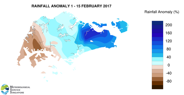
9        The daily temperatures in the first half of February 2017 ranged between 22.5°C and 34.1°C. During the monsoon surge episode, the days were windy and cool with the daily minimum temperatures ranging between 22.5°C and 24.6°C.

10       About two-third of the island received above normal rainfall in the first half February 2017. The highest rainfall of 154mm (141% above average) was recorded around Pasir Ris area. Rainfall was lowest around Jurong where 22.8mm (70% below average) was recorded.

[1] A monsoon surge refers to a strengthening of winds over the South China Sea, causing extensive rainclouds to form over our surrounding region.

FortnightRain_Anomaly_201702a

CLIMATE STATION STATISTICS FOR FEBRUARY (Climatological reference period: 1981 – 2010)

Mean daily maximum temperature 32.0 °C
Mean daily minimum temperature 24.3 °C
Mean monthly temperature 27.1 °C
Mean rainfall for the month 112.8 mm
Mean number of rain days 8
Highest monthly mean daily maximum temperature 33.5 °C (2010)
Lowest monthlymean daily minimum temperature 23.0 °C (1982)
Highest monthly rainfall 470.4 mm (1984)
Lowest monthly rainfall 6.3 mm (2010)


February 9, 2017

Weather update 9 February 2017

A temporary reprieve from the wet weather that Singapore has been experiencing this past week can be expected for the next few days. This is due to an incursion of drier air over the region, bringing generally fair and occasionally windy conditions to Singapore.

Rainy conditions can be expected again when a monsoon surge* is forecast to affect the South China Sea from around this Sunday (12 February). The surge will bring windy conditions with widespread rain, heavy at times, on some days in the coming week. The daily temperature during this period is expected to range between 22°C and 29°C.

*A monsoon surge refers to a strengthening of winds over the South China Sea, causing extensive rainclouds to form over our surrounding region.

(Issued on 9 Feb 2017)

February 1, 2017

Start of Dry Phase of the Northeast Monsoon

Short-duration thundery showers on some days

Singapore, 1 February 2017  – In the first fortnight of February 2017, the prevailing Northeast Monsoon season is forecast to enter its dry phase, which is characterised by drier weather and occasionally windy conditions. During this period, the low level winds are forecast to blow predominantly from the northeast or northwest.

2          Compared to the second half of January 2017 when Singapore experienced wet weather conditions on most days, the first fortnight of February 2017 is forecast to be drier and warmer. In addition, the daily temperature is expected to range between 23°C and 33°C, and could reach a high of around 34°C on some days.

3          Climatologically, February is the driest month of the year. During the dry phase of the Northeast Monsoon season, the monsoon rain belt typically lies south of the Equator, resulting in fewer rain days[1] for Singapore. For the first fortnight of February 2017, short-duration thundery showers due to strong solar heating of land areas coupled with convergence of winds can still be expected mostly in the afternoon on four or five days. Rainfall for the first half of February 2017 is forecast to be below normal.

4         For updates of the daily weather and haze forecast, please visit our MSS website (https://www.weather.gov.sg), NEA website (www.nea.gov.sg), or download the myENV app, MSS’ Weather@SG app.

[1] A rain day is defined as a day in which rainfall recorded for that day is 0.2mm or more.

Review: 1 – 31 January 2017

5          Northeast Monsoon conditions prevailed over the region in January 2017 with the low level winds blowing predominantly from the northeast and occasionally from the northwest.

6          The region experienced two episodes of monsoon surge[2] in the second half of January 2017. The first monsoon surge on 22-24 January 2017 brought overcast and occasionally windy conditions with periods of widespread moderate to heavy showers to Singapore. Over the Lunar New Year weekend on 28-29 January 2017, the second monsoon surge brought widespread showers mostly over the sea areas south and east of Singapore, while brief light to moderate afternoon showers fell over the island. For most other days in January 2017, Singapore experienced thundery showers in the afternoon. The highest total daily rainfall recorded during the month was 106.0mm around the Kallang area on 23 January 2017.

7          In January 2017, the daily maximum temperatures ranged between 25.9°C and 35.1°C, and the daily minimum temperatures ranged between 21.7°C and 25.4°C. While cooler temperatures were recorded in the second half of the month due to rainy weather, there were some warm days during the month as well. At the Changi climate station, the daily maximum temperature of 33.7°C recorded on 8 January 2017 surpassed the record highest daily maximum temperature for January by 0.1°C set on 27 January 1998. In addition, the mean monthly temperature of 26.9°C for January 2017 is 0.4°C above the long-term mean for January.

8          There were 21 rain days recorded for the month at the Changi climate station, which is significantly higher than the long-term average of 13 rain days for January. Despite the high number of rain days, the monthly rainfall recorded at the climate station in January 2017 was near normal as the rain was less heavy compared to other parts of the island. Most parts of Singapore received above normal rainfall in January 2017. The highest rainfall of 389.4mm (70% above average) was recorded around Paya Lebar area. Rainfall was lowest around Clementi where 177.6mm (18% below average) was recorded.

[2] A monsoon surge refers to a strengthening of winds over the South China Sea, causing extensive rainclouds to form over our surrounding region.


FortnightRain_Anomaly_201701b

CLIMATE STATION STATISTICS FOR FEBRUARY (Climatological reference period: 1981 – 2010)

Mean daily maximum temperature 32.0 °C
Mean daily minimum temperature 24.3 °C
Mean monthly temperature 27.1 °C
Mean rainfall for the month 112.8 mm
Mean number of rain days 8
Highest monthly mean daily maximum temperature 33.5 °C (2010)
Lowest monthlymean daily minimum temperature 23.0 °C (1982)
Highest monthly rainfall 470.4 mm (1984)
Lowest monthly rainfall 6.3 mm (2010)