Cooler nights expected on a few days
Singapore, 16 September 2016 – The prevailing Southwest Monsoon conditions are forecast to persist for the rest of September 2016. During the period, the low level winds are expected to blow mainly from the southwest. With the expected presence of low pressure systems such as tropical storms in our nearby region, the winds could turn to blow from the west on some days.
2 In the second half of September 2016, strong solar heating of land areas could give rise to thundery showers over Singapore on five to seven days, mostly in the late morning and early afternoon. In addition, the development of Sumatra squalls to the west of Singapore is expected to bring widespread thundery showers with occasional gusty winds on two or three days in the pre-dawn hours and morning. Higher rainfall is expected in the second fortnight of this month compared to that in the first fortnight, and the total rainfall for September 2016 is expected to be above normal.
3 For the rest of the month, the daily maximum temperatures on most days are expected to range between 32°C and 33°C. On rainy days, the daily minimum temperature, in particular during the night, would be cooler than normal and range between 22°C and 24°C.
4 For updates of the daily weather and haze forecast, please visit our MSS website (https://www.weather.gov.sg), NEA website (www.nea.gov.sg), the haze microsite (www.haze.gov.sg) or download the myENV app, MSS’ Weather@SG app.
REVIEW: 1 – 15 September 2016
5 In the first half of September 2016, Southwest Monsoon with low level winds blowing mostly from the southeast or southwest prevailed over the region.
6 During the period, Singapore experienced a few warm days in the first few days of the month where the highest daily maximum temperature recorded was 34.2°C. The lowest daily maximum temperature recorded was 29.4°C on 12 September 2016 when rain fell over the island from the early morning and eased off in the later part of the afternoon. The lowest daily minimum temperature recorded ranged between 21.9°C and 25.8°C.
7 On a few days during the review period, squall lines that developed over Sumatra or the Strait of Malacca passed over Singapore, bringing widespread thundery showers and gusty winds in the pre-dawn hours and morning. Arising from the squally weather, rainfall was heaviest on 14 September 2016 over the Paya Lebar-Macpherson area where a total of 86.6mm of rainfall was recorded. Overall, most of the thundery showers in the first half of the month fell in the late morning and early afternoon, and were due to strong solar heating of land areas.
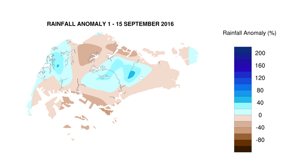
8 In the first fortnight of September 2016, rainfall was slightly above normal over the central and western parts of Singapore. The highest rainfall of 128.9mm (54% above average) was recorded around the Paya Lebar area. Rainfall was lowest around Sentosa island where 39.8mm (53% below average) was recorded. 
CLIMATE STATION STATISTICS FOR SEPTEMBER (Climatological reference period: 1981 – 2010)
| Mean daily maximum temperature | 31.4 °C |
| Mean daily minimum temperature | 24.8 °C |
| Mean monthly temperature | 27.6 °C |
| Mean rainfall for the month | 156.5 mm |
| Mean number of rain days | 13 |
| Highest monthly mean daily maximum temperature | 32.2 °C (1997) |
| Lowest monthlymean daily minimum temperature | 23.6 °C (1986) |
| Highest monthly rainfall | 440.4 mm (1988) |
| Lowest monthly rainfall | 23.7 mm (1994) |
