Singapore, 1 June 2020 – The wet and humid weather in May 2020 is forecast to continue into the first fortnight of June 2020. During this period, it is also expected to be warm, and daily highs of around 35°C can be expected on a few days. With the low-level winds over Singapore blowing from the southeast on most days, more warm nights can be expected in the coming fortnight compared to the last fortnight of May 2020.
2 With the prevailing Southwest Monsoon persisting in June 2020, the low-level winds over Singapore are forecast to blow mostly from the southeast, and to blow from the southwest or west on some days in the coming fortnight.
3 In the coming fortnight, the monsoon rain band is forecast to remain over the equatorial region. On most days during the period, short-duration moderate to heavy thundery showers can be expected between the late morning and afternoon over parts of the island. On two or three days, widespread thundery showers with gusty winds due to Sumatra squalls are expected between the predawn hours and morning. Overall, the rainfall for the first half of June 2020 is forecast to be above-average over most parts of Singapore.
4 During the fortnight, it is expected to be warm on most days with the daily temperature ranging between 25°C and 34°C, and with maximum temperatures of around 35°C on a few days. Warm and humid conditions can be expected on some nights with night-time temperatures around 28°C, especially when the prevailing winds blow from the southeast and bring in warm and humid air from the sea.
5 For updates of the daily weather and haze situation, please visit the MSS website (https://www.weather.gov.sg), NEA website (www.nea.gov.sg), or download the myENV app, MSS’ Weather@SG app, and the haze microsite (www.haze.gov.sg).
REVIEW (1 – 31 May 2020)
6 In the second half of May 2020, the light and variable winds over Singapore and the surrounding region gradually strengthened to blow from the southeast or southwest. This shift in winds signalled the end of the inter-monsoon period and the start of the Southwest Monsoon season in late-May 2020.
7 On most days in the month, moderate to heavy thundery showers fell over the island in the afternoon due to strong solar heating of land areas. On a few of these days, the showers extended into the evening. On two occasions, Singapore experienced thundery showers in the night due to large-scale wind convergence in the surrounding region. The wet weather in May 2020 was also due to the passage of Sumatra squalls over Singapore on some days. This brought widespread thundery showers and gusty winds between the early and predawn hours. On 22 May 2020, moderate to heavy thundery showers fell over the island in the afternoon and evening. The daily total rainfall of 99.2mm recorded at Jurong that day was the highest daily total for May 2020.
8 May 2020 was also a warm month. The daily maximum temperature exceeded 34°C on most days. On 8 of these days, the daily maximum temperature reached 35°C or more. The highest daily maximum temperature of 35.8°C was recorded at Admiralty on 22 May 2020. There were a few warm nights where the night-time minimum temperature was around 28°C, over the southern and eastern parts of the island. At the Changi climate station, the mean monthly temperature for May 2020 was 28.9°C, which was 0.6°C higher than the month’s long-term average.
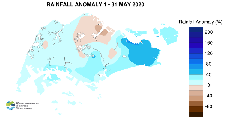
9 Most parts of the island received above-average rainfall in May 2020. The highest anomaly of 68% above average was recorded at Pasir Ris. The anomaly was lowest at Seletar at 35% below average.
CLIMATE STATION STATISTICS
Long-term Statistics for June
(Climatological reference period: 1981 – 2010)
| Average daily maximum temperature | 32.0°C |
| Average daily minimum temperature | 25.4 °C |
| Average monthly temperature | 28.3 °C |
| Average rainfall | 130.7 mm |
| Average number of rain days | 12 |
Historical Extremes for June
(Rainfall since 1869 and temperature since 1929)
| Highest monthly mean daily maximum temperature: | 33.2 °C (1997) |
| Lowest monthly mean daily minimum temperature: | 23.2 °C (1965) |
| Highest monthly rainfall ever recorded: | 378.7 mm (1954) |
| Lowest monthly rainfall ever recorded: | 21.8 mm (2009) |