Singapore, 30 April 2020 – The warm weather in April 2020 is expected to continue into the first half of May 2020. More showers are also forecast in the next two weeks with the presence of the monsoon rain band over the equatorial Southeast Asia region. During this period, daily maximum temperatures of around 34°C are expected on most days and could reach highs of around 35°C on a few days.
2 The prevailing inter-monsoon conditions are expected to persist into May 2020. In the first half of May 2020, the low-level winds are forecast to be light and variable in direction and may blow from the southeast or southwest on some days.
3 On most days in the first fortnight of May 2020, short-duration thundery showers with frequent lightning are expected between the late morning and afternoon. This is due to strong daytime heating of land areas and convergence of winds over Singapore and the surrounding vicinity. The showers could extend into the evening on one or two of these days. In addition, the presence of low-pressure systems developing over the western Pacific Ocean and the South China Sea are expected to bring a temporary shift in the winds to blow from the southwest or west over Singapore and the surrounding vicinity. This could bring a few days of widespread thundery showers with occasional gusty winds between the predawn and morning, arising from the passage of Sumatra squalls over the island. Overall, the rainfall for Singapore in the first fortnight of May 2020 is forecast to be above-normal over most parts of the island.
4 May is normally one of the warmest months of the year. The first half of May 2020 is forecast to be warm with the daily temperature on most days ranging between 25°C and 34°C. On a few days, the daily maximum temperature could rise to around 35°C. On some nights, warm and humid conditions with night-time temperatures of around 28°C are expected when prevailing winds blowing from the southeast bring warm and humid air from the sea.
5 For updates of the daily weather and haze situation, please visit the MSS website (https://www.weather.gov.sg), NEA website (www.nea.gov.sg), or download the myENV app, MSS’ Weather@SG app, and the haze microsite (www.haze.gov.sg).
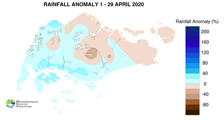
REVIEW (1 – 29 April 2020)
6 The Northeast Monsoon that prevailed over Singapore since December 2019 has ended with the onset of inter-monsoon conditions in end April 2020. The low-level winds in the region weakened in late April 2020 and have become light and variable in direction.
7 April 2020 was wetter compared to the first three months of 2020. On most days in April 2020, thundery showers fell over the island in the afternoon due to strong solar heating of land areas. On 7 April 2020, a Sumatra squall brought widespread heavy showers to many parts of Singapore in the early and predawn hours. The daily total rainfall of 115.0mm recorded at Tuas that day was the highest daily total for April 2020.
8 April 2020 was also warm and humid. At the Changi climate station, the mean monthly temperature for April 2020 of 28.9°C (as of 29 April 2020) was 0.9°C higher than the month’s long-term average. Higher than usual temperatures were experienced over many parts of the island during the month. On most days, the daily maximum temperature reached 34°C, and exceeded 35°C on 15 days. The highest daily maximum temperature of 35.8°C was recorded at Clementi on 10 April 2020. There were also a few warm nights where the night-time temperature hovered around 28°C, mainly in the southern and eastern parts of the island.
9 About half of the island recorded above-normal rainfall in April 2020. The rainfall recorded at Jurong was 37% above average while that recorded at MacRitchie was 42% below average.
CLIMATE STATION STATISTICS
Long-term Statistics for May
(Climatological reference period: 1981 – 2010)
| Average daily maximum temperature | 32.2 °C |
| Average daily minimum temperature | 25.4 °C |
| Average monthly temperature | 28.3 °C |
| Average rainfall | 171.2 mm |
| Average number of rain days | 14 |
Historical Extremes for May
(Rainfall since 1869 and temperature since 1929)
| Highest monthly mean daily maximum temperature: | 33.6 °C (1997) |
| Lowest monthly mean daily minimum temperature: | 23.5 °C (1974) |
| Highest monthly rainfall ever recorded: | 386.6 mm (1892) |
| Lowest monthly rainfall ever recorded: | 41.6 mm (1997) |