Fortnightly Weather Outlook for 1 – 15 April 2020
Singapore, 1 April 2020 – In the first fortnight of April 2020, Singapore and the surrounding region can expect more showers with the proximity of the monsoon rain band close to the Equator. The current warm conditions are forecast to continue in the first two weeks of April 2020 with daily maximum temperatures reaching a high of around 35°C on a few days.
2 Climatologically, April is one of the warmest months of the year, with high lightning activity. During this fortnight, short-duration thundery showers are expected in the afternoon on most days due to strong daytime heating of land areas coupled with convergence of winds over Singapore. On one or two of these days, the thundery showers could extend into the evening. On a few days, a brief intrusion of a dry air mass extending from South China Sea over the region could bring dry and warm weather over Singapore. Overall, rainfall for the first fortnight of April 2020 is expected to be near-normal over most parts of Singapore.
3 While more rain days are expected in the first half of April 2020 compared to the previous fortnight, warm conditions can still be expected on some days. The daily temperatures are expected to range between 25°C and 34°C on most days. The daily maximum temperature could reach a high of around 35°C, in particular on days when there are few clouds in the sky.
4 The prevailing Northeast Monsoon conditions with low-level winds blowing from the northeast or east are expected to persist in the first fortnight of April 2020. Around the end of the fortnight, a gradual weakening of the low-level winds can be expected, signalling the transition to inter-monsoon conditions. The later than usual onset of the inter-monsoon this year, normally by end March, could be attributed to more frequent high-pressure systems over the Western Pacific Ocean which brought persistent easterly winds to the surrounding region.
5 For updates of the daily weather and haze situation, please visit the MSS website (https://www.weather.gov.sg), NEA website (www.nea.gov.sg), or download the myENV app, MSS’ Weather@SG app, and the haze microsite (www.haze.gov.sg).
REVIEW (1 – 31 March 2020)
6 Northeast Monsoon conditions prevailed in March 2020. During the period, the low-level winds over Singapore and the surrounding region blew mainly from the northwest or northeast. Most of Southeast Asia including Singapore experienced dry and warm conditions in March 2020.
7 In Singapore, it was warm on most days in March 2020. There were 27 days with daily maximum temperatures exceeding 34.0°C, and 10 days when the daily maximum temperature was more than 35.0°C. The month’s highest daily maximum temperature of 36.3°C was recorded at Paya Lebar on 13 March 2020, the highest recorded so far this year.
8 At the Changi climate station, the mean monthly temperature for March 2020 of 28.6°C was 1.1°C higher than the month’s long-term average. The monthly mean minimum temperature for March 2020 was 25.9°C. This was 1.3°C higher than the March long-term average and is the third highest mean minimum temperature recorded for March since 1929, after March 2016 (26.6°C) and March 1998 (26.3°C).
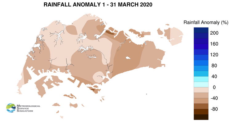
9 During the month, the occasional intrusion of a dry air mass from the southern South China Sea over Singapore and the surrounding vicinity brought little or no rainfall over a two-week period. In the last week of March 2020, it was generally wet over most parts of the island. This was due to the passage of the Madden-Julian Oscillation (MJO)[1] which enhanced the development of thunderstorm clouds over Singapore and the surrounding region. Most of the thundery showers in March 2020 fell in the afternoon due to large-scale wind convergence over the surrounding vicinity. Thundery showers fell over many areas of the island on 23 March 2020. The daily total rainfall recorded that day was 87.8mm at Pulau Ubin, which is the highest recorded for March 2020.
10 Singapore received below normal rainfall in March 2020. The highest anomaly of 67% below average was recorded at Seletar. The lowest anomaly of 14% below average was recorded at Sentosa.
[1] The MJO is characterised by an eastward propagation of clouds and rainfall over the tropical regions from the Indian Ocean to the western Pacific Ocean, with a period of between 30 and 60 days on average. The MJO consists of two phases – an enhanced rainfall (convection) phase and a suppressed rainfall phase.
CLIMATE STATION STATISTICS
Long-term Statistics for April
(Climatological reference period: 1981 – 2010)
| Average daily maximum temperature | 32.3 °C |
| Average daily minimum temperature | 25.0 °C |
| Average monthly temperature | 28.0 °C |
| Average rainfall | 154.8 mm |
| Average number of rain days | 14 |
Historical Extremes for April
(Rainfall since 1869 and temperature since 1929)
| Highest monthly mean daily maximum temperature: | 33.9 °C (1983) |
| Lowest monthly mean daily minimum temperature: | 23.1 °C (1934) |
| Highest monthly rainfall ever recorded: | 454.9 mm (1900) |
| Lowest monthly rainfall ever recorded: | 16.6 mm (1977) |