Wet weather expected in second half of May 2017
Singapore, 16 May 2017 – Inter-monsoon conditions characterised by light winds are expected to persist in the next fortnight. Towards the end of the month, the winds are forecast to gradually strengthen and blow from the southeast or southwest as the inter-monsoon conditions gradually transition to Southwest Monsoon conditions around end May/early June 2017.
2 For the second half of May 2017, short-duration thundery showers are expected on six to eight days in the late morning and afternoon, and could extend into the evening on one or two of these days. The thunderstorms can be heavy on some days because of strong convection due to daytime heating of land areas. In addition, widespread thundery showers accompanied by gusty winds due to Sumatra squalls can be expected between the predawn and early morning on two or three days. Overall, the rainfall for May 2017 is forecast to be slightly above normal.
3 For the rest of the month, the daily temperature on most days is expected to range between 24oC and 33°C. On a few days, the daily maximum temperature could reach a high of 34°C. As the Southwest Monsoon conditions gradually sets in around the end of May/early June 2017, the nights can be relatively warm, in particular on non-rain days. This usually occurs when the weak southeast winds bring warm, humid air from the sea toward the land.
4 For updates of the daily weather forecast, please visit our MSS website (https://www.weather.gov.sg), NEA website (www.nea.gov.sg), or download the myENV app, or the MSS’ Weather@SG app.
Review: 1 – 15 May 2017
5 Inter-monsoon conditions prevailed over the region in the first fortnight of May 2017, and the low level winds were generally light and variable in direction. On some days, the prevailing winds blew from the southwest or west due to the influence of low pressure systems in the nearby region.
6 In the first half of the month, there were a few warm days where temperatures above 34°C were recorded. The highest temperature recorded during the period was 34.5°C around the Seletar area on 9 May 2017. At the Changi climate station, the mean daily maximum temperature recorded in the first fortnight of May 2017 was 28.4°C, which is 0.1°C above the long-term mean for May.
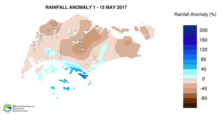
7 On most days in the first half of May 2017, the thundery showers in the late morning and early afternoon were due to strong solar heating of land areas coupled with convergence of winds over Singapore and the surrounding vicinity. On a few dayswidespread thundery showers and gusty winds to Singapore between the pre-dawn and the early morning. The showers were heaviest on 12 May 2017 where the highest daily rainfall total recorded was 84.4mm around Sentosa.
8 Most parts of Singapore received below normal rainfall in the first fortnight of May 2017. The lowest rainfall of 40.4mm (61% below average) was recorded around the Upper Thomson area. Rainfall was highest around Sentosa where 181.4mm (103% above average) was recorded.
CLIMATE STATION STATISTICS FOR MAY (Climatological reference period: 1981 – 2010)
| Mean daily maximum temperature | 32.2 °C |
| Mean daily minimum temperature | 25.4 °C |
| Mean monthly temperature | 28.3 °C |
| Mean rainfall for the month | 171.2 mm |
| Mean number of rain days | 14 |
| Highest monthly mean daily maximum temperature | 33.6 °C (1997) |
| Lowest monthly mean daily minimum temperature | 24.5 °C (1981.1982.1984,1989) |
| Highest monthly rainfall | 370.8 mm (1998) |
| Lowest monthly rainfall | 41.6 mm (1997) |