Warm days with daily maximum temperature around 35°C expected on some days. Mostly short-duration thundery showers in the afternoon in second half of March 2018.
Singapore, 16 March 2018 – The prevailing Northeast Monsoon conditions with low level winds blowing predominantly from the northeast or northwest are forecast to persist for the rest of March 2018. A gradual transition of the low level winds to become light and variable in direction is expected around the end of the month, giving indication of the onset of the inter-monsoon period in early April 2018.
2 For the rest of March 2018, thundery showers due to daytime heating of land areas are expected on five to seven days. These showers are forecast to be of short-duration lasting around an hour or less in the afternoon, and extending into the evening on one or two of these days. On one or two mornings in the second half of March 2018, the eastward passage of Sumatra squall lines from the Strait of Malacca towards the South China Sea is forecast to bring thundery showers with gusty winds to Singapore. For the month as a whole, the total rainfall is forecast to be below the monthly average of 170.3mm.
3 On some days in the next fortnight, a mass of dry air from northern Asia is forecast to move over parts of Southeast Asia. The passage of dry air could bring fair and warm conditions over Singapore, and the daily maximum temperature on these days could reach up to 35°C. The daily maximum and minimum temperatures on most days in the fortnight are expected to rise to around 34°C and dip to low of around 24°C respectively.
4 For updates of the daily weather forecast, please visit the MSS website (https://www.weather.gov.sg), NEA website (www.nea.gov.sg), or download the myENV app, or the MSS’ Weather@SG app.
REVIEW (1 – 15 March 2018)
5 In the first half of March 2018, Singapore and the surrounding region experienced Northeast Monsoon conditions with the low level winds blowing mainly from the northwest or northeast.
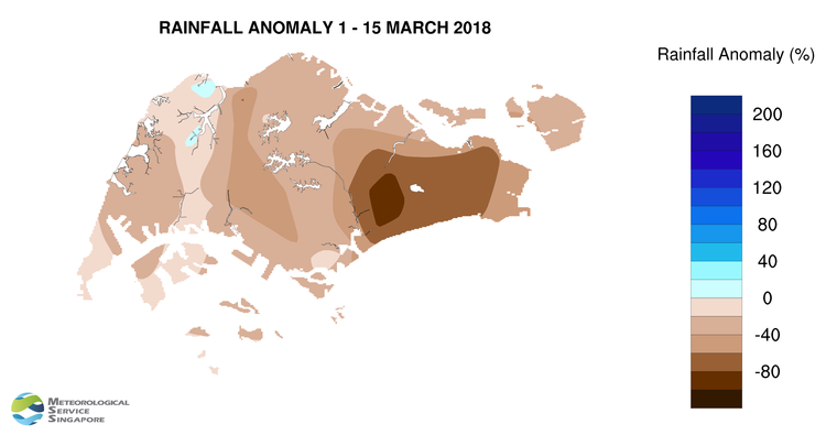
6 During the fortnight, most of the thundery showers fell in the afternoon arising from strong daytime heating of land areas and convergence of winds in the surrounding vicinity. In the second week of March 2018, there was a weak monsoon surge[1] that affected the South China Sea and the surrounding coastal land areas. The weak surge brought windy conditions and passing showers to Singapore on a few days. In the first fortnight of March 2018, rainfall was heaviest on 2 March 2018 at Ang Mo Kio, where the daily total rainfall recorded was 92.5mm.
7 There were a few warm weather days in the first half of March 2018. The highest daily maximum temperature was 35.7°C, recorded at Clementi on 3 March 2018. The daily minimum temperature recorded in the fortnight ranged between 22.6°C and 24.1°C.
8 Most parts of Singapore received well below-normal rainfall in the first half of March 2018. The lowest rainfall of 15mm (87% below average) was recorded in the eastern part of the island. Rainfall was highest at Choa Chu Kang where 130.1mm (7% above average) was recorded.
[1] A monsoon surge refers to the strengthening of northeasterly winds blowing from a strong high-pressure system over the northern Asian continent toward the South China Sea, bringing periods of prolonged widespread rain and windy conditions to the surrounding region including Singapore and Peninsular Malaysia. (Further information is available at https://www.weather.gov.sg/learn_weather_systems/).
CLIMATE STATION STATISTICS FOR MARCH (Climatological reference period: 1981 – 2010)
| Mean daily maximum temperature | 32.0 °C |
| Mean daily minimum temperature | 24.6 °C |
| Mean monthly temperature | 27.5 °C |
| Mean rainfall for the month | 170.3 mm |
| Mean number of rain days | 13 |
| Highest monthly mean daily maximum temperature | 34.1 °C (1998) |
| Lowest monthly mean daily minimum temperature | 23.7 °C (1982) |
| Highest monthly rainfall | 361.3 mm (1984) |
| Lowest monthly rainfall | 34.3 mm (1997) |