Some warm days can still be expected
Singapore, 17 April 2017 – In the second fortnight of April 2017, the prevailing inter-monsoon conditions over Singapore and the surrounding region are expected to persist and extend into May 2017.
2 During the inter-monsoon period, the low level winds are forecast to be predominantly light and variable in direction. Moderate to heavy short-duration thundery showers are expected mostly in the afternoon with a possibility of extending into the evening on a few days due to strong solar heating of land areas coupled with convergence of winds over Singapore and the surrounding vicinity.
3 In the second half of April 2017, short-duration thundery showers are expected on six to eight days. In addition, on two or three days in the fortnight, the passage of Sumatra squalls is expected to bring widespread thundery showers accompanied by gusty winds between pre-dawn and early morning. Climatologically, lightning activity during the inter-monsoon months is the highest compared to other times of the year. The rainfall for April 2017 is forecast to be slightly above normal.
4 Although wet weather is forecast on most days in the last two weeks of April 2017, some warm days can still be expected, with the daily maximum temperature reaching a high of around 35°C. On most days, the daily temperature range is likely to range between 24°C and 34°C.
5 For updates of the daily weather forecast, please visit our MSS website (https://www.weather.gov.sg), NEA website (www.nea.gov.sg), or download the myENV app, or the MSS’ Weather@SG app.
Review: 1 – 16 April 2017
6 During the period from 1 to 16 April 2017, the region experienced inter-monsoon conditions where the low level winds were generally weak and variable in direction. The presence of tropical cyclones in the southern Indian Ocean on some days brought a temporary shift in the winds over Singapore and the surrounding region to blow from the west or southwest.
7 In the first week of April 2017, the occurrence of Sumatra squalls brought widespread thundery showers accompanied by gusty winds over Singapore on several days between midnight and the early morning. In the second half of the first fortnight, the prevailing winds were light and variable in direction, and Singapore experienced thundery showers mostly in the afternoon due to strong daytime heating of land areas. The highest daily rainfall total of 61.7mm was recorded on 13 April 2017 around the Sembawang area.
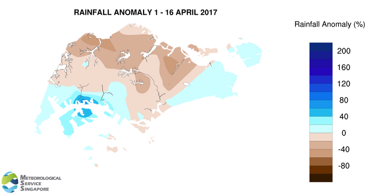
8 There were some warm days in the first two weeks of April 2017. The daily maximum temperature recorded during the period ranged between 29.6°C and 34.7°C, of which there were five days where the maximum temperature was more than 34°C. The daily minimum temperature ranged between 22.3°C and 26.2°C.
9 About two-third of Singapore received below normal rainfall in the first half of April 2017. The lowest rainfall of 56.3mm (57% below average) was recorded around the Kranji area. Rainfall was highest in the Jurong area where 246.4mm (71% above average) was recorded.
CLIMATE STATION STATISTICS FOR APRIL (Climatological reference period: 1981 – 2010)
| Mean daily maximum temperature | 32.3 °C |
| Mean daily minimum temperature | 25.0 °C |
| Mean monthly temperature | 28.0 °C |
| Mean rainfall for the month | 154.8 mm |
| Mean number of rain days | 14 |
| Highest monthly mean daily maximum temperature | 33.9 °C (1983) |
| Lowest monthly mean daily minimum temperature | 23.9 °C (1982) |
| Highest monthly rainfall | 311.6 mm (2000) |
| Lowest monthly rainfall | 43.1 mm (1983) |