Fortnightly Weather Outlook for 16 – 30 September 2019
Singapore, 16 September 2019 – The prevailing Southwest Monsoon conditions in the region are forecast to persist for the rest of September 2019. During this period, the low level winds are expected to blow from the southeast or south, and on occasions, shift to blow from the southwest.
2 In the coming fortnight, dry air from high pressure systems over northern Australia are forecast to continue blowing over the southern Southeast Asia region, including Singapore. Persisting cooler sea surface temperatures over the tropical eastern Indian Ocean[1] (positive Indian Ocean Dipole) will also suppress raincloud formation over the surrounding region. Additionally, with the monsoon rain band forecast to remain over northern Southeast Asia, away from Singapore, the prevailing dry weather is expected to continue into the second fortnight of the month.
3 In the last week of the month, there could be some brief respite as the high pressure system over northern Australia is expected to weaken, and with strong solar daytime heating of land areas, localised short-duration showers can be expected in the afternoon on a few days.
4 The rainfall for September 2019 is likely to be significantly below September’s climatological normal of 185.4mm. September 2019 is thus likely to be the third consecutive month, following July and August 2019, with more than 40% below-normal monthly rainfall, giving rise to a potential rainfall deficit [2] situation. The total rainfall for July and August 2019 recorded at rainfall stations across the island with long term records was 51% and 82% below normal respectively. The last occurrence of a rainfall deficit situation in Singapore was in 2014 from January to March, where the average rainfall total for each month across Singapore was 67%, 89% and 50% below the month’s normal.
5 For the rest of September 2019, the prevailing warm conditions are forecast to continue. The daily temperature is expected to range between 26°C and 34°C on most days, with highs exceeding 35°C on a few days. The nights are expected to be warm with daily minimum temperatures of 27°C or more on some days. Night-time temperatures in the southern and eastern coastal areas could be warmer, at around 28°C, when prevailing winds blowing from the southeast bring warm and humid air from the surrounding seas.
6 The prevailing dry weather over southern Southeast Asia is expected to persist in the coming fortnight. Hotspots with smoke plumes continue to be observed over parts of Sumatra and Kalimantan. Singapore may continue to experience hazy conditions during the fortnight, depending on the wind conditions and the proximity and extent of the fires.
7 For updates of the daily weather and haze situation, please visit the MSS website (https://www.weather.gov.sg), NEA website (www.nea.gov.sg), or download the myENV app, MSS’ Weather@SG app, and the haze microsite (www.haze.gov.sg).
REVIEW (1 – 15 September 2019)
8 During the first fortnight of September 2019, Southwest Monsoon conditions continued to prevail, and the low level winds blew from the southeast or southwest.
9 In the first half of September 2019, the weather over Singapore was generally dry and warm. These conditions were due to suppressed raincloud formation arising from dry air that was blown to the southern Southeast Asia region from high pressure systems over northern Australia, coupled with the persisting cooler sea surface temperature over the tropical Indian Ocean. There were however a few days when brief showers fell over Singapore. In particular, on 4 September 2019, the thundery showers over many parts of the island were due to convergence of winds over Singapore and the surrounding vicinity. Rainfall was heaviest over the western part of the island, and the highest daily total rainfall recorded that day was 93.3mm at Jurong West.
10 In the second week of September 2019, smoke haze from hotspots in central and southern Sumatra were blown in by the prevailing winds to Singapore. This brought slightly hazy conditions to the island with the air quality in the high end of the Moderate range on most days of the week. A sudden deterioration in the haze situation on 14 September 2019 caused the 24-hour PSI to dip into the Unhealthy range.
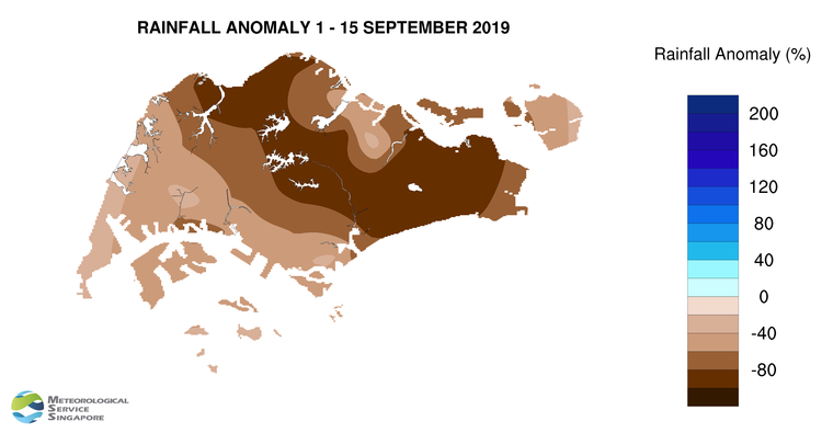
11 The first half of September 2019 was warm, with daily maximum temperatures reaching at least 34.0°C on 9 days (as at 13 September 19). The highest daily maximum temperature of 34.8°C was recorded on 12 September 2019 over the northern part of the island at Admiralty.
12 Significantly well-below-average rainfall was recorded across the island in September 2019. The lowest anomaly of 100% below-average was recorded at a few stations in the eastern part of the island.
[1] The Indian Ocean Dipole (IOD) refers to the sustained change to the difference between sea surface temperatures (SSTs) of the tropical western and eastern Indian Ocean. The IOD varies between three phases – positive, negative and neutral. A positive (negative) phase occurs when cooler (warmer) SSTs develop in the eastern Indian Ocean, resulting in below (above) normal rainfall in the eastern Indian Ocean and the surrounding region. More information on the IOD can be found at https://www.weather.gov.sg/LEARN_climate/.
[2] A rainfall deficit refers to a period of at least 3 consecutive months with monthly rainfall more than 40% below the climatological rainfall, averaged over the rainfall stations with long term records across the island.
CLIMATE STATION STATISTICS
Long-term Statistics for September
(Climatological reference period: 1981 – 2010)
| Average daily maximum temperature | 31.4 °C |
| Average daily minimum temperature | 24.8 °C |
| Average monthly temperature | 27.6 °C |
| Average rainfall | 156.5 mm |
| Average number of rain days | 13 |
Historical Extremes for September
(Rainfall since 1869 and temperature since 1929)
| Highest monthly mean daily maximum temperature: | 32.2 °C (1997) |
| Lowest monthly mean daily minimum temperature: | 22.4 °C (1930) |
| Highest monthly rainfall ever recorded: | 440.4 mm (1988) |
| Lowest monthly rainfall ever recorded: | 23.7 mm (1994) |