Fortnightly Weather Outlook for 14 – 31 August 2020
Singapore, 14 August 2020 – In the second fortnight of August 2020, more thundery showers are expected, following the drier weather in the first fortnight of the month. During this period, the daily maximum temperature is expected to range between 32°C and 33°, and with daily highs of around 34°C on a few days.
2 The prevailing Southwest Monsoon conditions are forecast to persist in the second half of August 2020. During this period, the low-level winds over Singapore and the surrounding vicinity are forecast to blow from the southeast or southwest. On a few days during the fortnight, the winds could blow from the east.
3 On most days over the next two weeks, short-duration moderate to heavy thundery showers can be expected between the late morning and afternoon, and could extend into the evening on a few days. Convergence of winds in the surrounding vicinity could bring thundery showers over the island on a few nights. In addition, widespread thundery showers with gusty winds due to the passage of Sumatra squalls are forecast on one or two mornings. Overall, more rainfall is expected in the second half of August 2020 compared to the first half of the month. The total rainfall for August 2020 is forecast to be near-average over most parts of the island.
4 While more showers are expected in the coming fortnight, there could still be a few warm days with daily highs of around 34°C. On most days, the daily temperature is forecast to range between 25°C and 33°C. Some nights can be relatively warm and humid when southeast winds bring warm, humid air from the sea toward the land. Night-time minimum temperatures of around 28°C can be expected on a few days.
5 For updates of the daily weather and haze situation, please visit the MSS website (https://www.weather.gov.sg), NEA website (www.nea.gov.sg), or download the myENV app, MSS’ Weather@SG app, and the haze microsite (www.haze.gov.sg).
REVIEW (1 – 13 August 2020)
6 In the first fortnight of August 2020, Southwest Monsoon conditions prevailed over Singapore and the surrounding region. During the period, the low-level winds blew from the southeast or southwest. There were some days when the winds over Singapore and the surrounding region strengthened to blow from the west due to the influence of a few tropical storms over the South China Sea and northwestern Pacific Ocean.
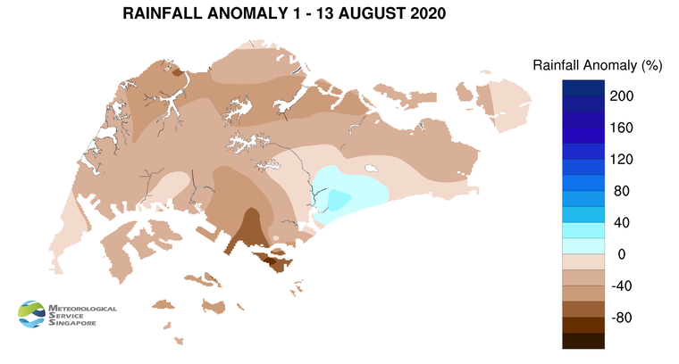
7 In the first fortnight of August 2020, the monsoon rain band was situated over the northern Southeast Asia region, resulting in drier weather over equatorial Southeast Asia including Singapore. There were however a few days where thundery showers fell over the island in the morning due to the passage of Sumatra squalls. The highest daily total rainfall of 115.6mm was recorded at Bedok South on 13 August 2020.
8 During the first half of August 2020, the daily maximum temperature was above 33°C on most days. There were a few dry and warm days where the daily maximum temperature exceeded 34°C. The highest daily maximum temperature of 35.4°C was recorded at Admiralty on 9 August 2020. On a few nights during the period, the daily minimum temperature over the southern, eastern and western coastal areas of the island were above 28°C.
9 Singapore received well below average rainfall over many parts of the island in the first fortnight of August 2020. The rainfall recorded at Sentosa Island was 84% below average while that recorded at Tanjong Katong was 32% above average.
CLIMATE STATION STATISTICS
Long-term Statistics for August
(Climatological reference period: 1981 – 2010)
| Average daily maximum temperature | 31.4°C |
| Average daily minimum temperature | 25.0 °C |
| Average monthly temperature | 27.9 °C |
| Average rainfall | 148.9 mm |
| Average number of rain days | 14 |
Historical Extremes for August
(Rainfall since 1869 and temperature since 1929)
| Highest monthly mean daily maximum temperature: | 32.6 °C (1997) |
| Lowest monthly mean daily minimum temperature: | 23.0 °C (1962) |
| Highest monthly rainfall ever recorded: | 526.8 mm (1878) |
| Lowest monthly rainfall ever recorded: | 18.0 mm (1888) |