Singapore, 1 October 2018 – The current Southwest Monsoon conditions with low level winds blowing from the southeast or south are expected to gradually weaken in the first fortnight of October 2018. In the second week of October, more showers are forecast for Singapore and the surrounding region. The showers are expected to bring some respite to the persisting dry and warm weather over Singapore since mid-September 2018.
2 During the fortnight, with weak winds and strong solar heating of land areas, Singapore can expect thundery showers mostly in the afternoon on six to eight days. Overall, the rainfall for the first fortnight of October 2018 is expected to be near-normal.
3 On most days in the fortnight, the daily temperature is forecast to range between 25°C and 33°C. On a few days when there is little or no rainfall, warm conditions with maximum temperatures of around 34°C can be expected.
4 For updates of the daily weather forecast, please visit our MSS website (https://www.weather.gov.sg), NEA website (www.nea.gov.sg), or download the myENV app, or the MSS’ Weather@SG app.
REVIEW (1 – 30 September 2018)
5 In September 2018, Southwest Monsoon conditions prevailed with the low level winds blowing mainly from the southeast or south.
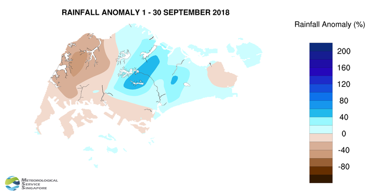
6 During the month, Singapore experienced thundery showers mostly in the late morning and afternoon. In the first half of the month, the thundery showers that fell over the island were due to wind convergence over Singapore and the surrounding vicinity and to the passage of Sumatra squalls that crossed over Singapore from the Strait of Malacca to the South China Sea. The heaviest rainfall in September 2018 occurred on 7 September at Upper Thomson where the daily total rainfall recorded was 121.6mm. Compared to the first half of September, there was less rainfall in the second half of the month. The thundery showers that fell over the island in the afternoon on some days in the last two weeks of September were localised and of short-duration. The overall rainfall in September 2018 was near-normal.
7 The last two weeks of September 2018 was also warmer and drier than the first half of the month. The daily maximum temperature in the first fortnight of the month ranged between 30.1°C and 33.6°C. In the second fortnight of the month, with fair and warm conditions, the daily maximum temperature recorded was between 31.8°C and 35.2°C. The daily minimum temperature during the month ranged between 21.4°C and 27.3°C
8 Above-average rainfall was recorded over two-thirds of the island in September 2018. The lowest rainfall of 88.2 mm (54% below average) was recorded at Choa Chu Kang West. Rainfall was highest at the Thomson area where 289.8 mm (59% above average) was recorded.
CLIMATE STATION STATISTICS FOR October
(Climatological reference period: 1981 – 2010)
| Mean daily maximum temperature | 31.7 °C |
| Mean daily minimum temperature | 24.7 °C |
| Mean monthly temperature | 27.6 °C |
| Mean rainfall for the month | 154.6 mm |
| Mean number of rain days | 15 |
| Highest monthly mean daily maximum temperature | 33.0 °C (2002) |
| Lowest monthly mean daily minimum temperature | 23.8 °C (1982) |
| Highest monthly rainfall | 351.4 mm (2003) |
| Lowest monthly rainfall | 10.8 mm (2002) |