A few warm days can still be expected
Singapore, 16 January 2017 – The prevailing Northeast Monsoon conditions over the region are forecast to persist into the second half of January 2017. During this fortnight, the low level winds are expected to continue to blow from the northeast or northwest.
2 The next two weeks of January 2017 is expected to be wetter than the first fortnight of the year. Short-duration thundery showers are expected on six to eight days, mostly in the afternoon, and on a few days could extend into the evening. In addition, there is a chance of a monsoon surge[1] developing over the southern South China Sea region in the second week of the fortnight. Singapore could experience periods of moderate to heavy rain lasting up to two days, accompanied by occasional windy conditions and cooler temperatures. Overall, the rainfall for January 2017 is forecast to be slightly below normal.
3 In the next fortnight, a few warm days can still be expected. The daily maximum temperatures on most days are forecast to be around 32°C or 33°C, and on a few days, the daily maximum temperatures could reach a high of around 34°C. On some rainy days, the daily minimum temperature is expected to be cooler, and could range between 22°C and 23°C.
4 For updates of the daily weather and haze forecast, please visit our MSS website (https://www.weather.gov.sg), NEA website (www.nea.gov.sg), or download the myENV app, MSS’ Weather@SG app.
Review: 1 – 15 January 2017
5 Northeast Monsoon conditions prevailed over the region in the first fortnight of 2017, and the low level winds during the period blew mostly from the northwest or north.
6 There were a few dry and warm days in the first two weeks of January 2017 where temperatures above 33°C were recorded at some stations. The highest temperature recorded in the first fortnight of January 2017 was 35.1°C at Sembawang on 9 January 2017. At the Changi climate station, the mean daily maximum temperature recorded in the first half of January 2017 was 31.3°C, which is 1.1°C above the long-term mean for January.
7 In the first fortnight of January 2017, Singapore experienced thundery showers in the afternoon and evening on several days due to strong solar heating of land areas coupled with convergence of winds in the surrounding vicinity. In addition, the occurrence of Sumatra squalls brought moderate to heavy thundery showers over many parts of Singapore between the predawn and early morning on a few days. The thundery showers were heaviest on New Year’s Day where the highest total daily rainfall recorded was 71.8mm in Jurong Island.
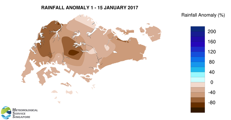
8 For the first two weeks of the year, Singapore received significantly below normal rainfall. The lowest rainfall of 12.8mm (88% below average) was recorded around the Jurong area, and rainfall was highest around the Paya Lebar area where 98.3mm (11% below average) was recorded.
[1] A monsoon surge is characteristic of the wet phase of the Northeast Monsoon season (Dec – Jan). It is due to the strengthening of northeasterly winds over the South China Sea and our surrounding region, and can bring widespread rain to coastal areas in the Southeast Asia region. Read more at https://www.weather.gov.sg/learn_weather_systems/
CLIMATE STATION STATISTICS FOR JANUARY (Climatological reference period: 1981 – 2010)
| Mean daily maximum temperature | 30.4 °C |
| Mean daily minimum temperature | 23.9 °C |
| Mean monthly temperature | 26.5 °C |
| Mean rainfall for the month | 234.6 mm |
| Mean number of rain days | 13 |
| Highest monthly mean daily maximum temperature | 31.8 °C (1998) |
| Lowest monthlymean daily minimum temperature | 22.6 °C (1981,1982) |
| Highest monthly rainfall | 600.9 mm (2004) |
| Lowest monthly rainfall | 15.4 mm (1997) |