A few warm days can still be expected
Singapore, 16 August 2017 – In the second half of August 2017, Singapore and the surrounding region will continue to be influenced by Southwest Monsoon conditions, characterised by low level winds that blow predominantly from the southeast or southwest.
2 The wet weather conditions experienced in the first half of August 2017 are forecast to persist in the second fortnight of August 2017. During the period, short-duration thundery showers due to strong solar heating of land areas are expected on six to eight days, mostly in the late morning and early afternoon. On one or two days within the upcoming two weeks, the occurrence of Sumatra squalls could bring widespread thundery showers accompanied with gusty winds to Singapore between the predawn and early morning. Overall, the rainfall for August 2017 is forecast to be near-normal.
3 The daily temperature for the rest of the month is not expected to deviate significantly from that experienced in the first two weeks of August 2017. On most days, the daily temperature is expected to range between 25°C and 33°C, and on a few days in the later part of the month, warm conditions can be expected with the daily maximum temperature reaching a high of around 34°C. During the fortnight, the daily minimum temperatures could register a value between 22°C and 23°C, in particular when rain falls over the island for most part of the day.
4 For updates of the daily weather forecast, please visit our MSS website (https://www.weather.gov.sg), NEA website (www.nea.gov.sg), or download the myENV app, or the MSS’ Weather@SG app.
Review: 1 – 15 August 2017
5 In the first fortnight of August 2017, Southwest Monsoon conditions prevailed over Singapore and the surrounding region, with the low level winds blowing predominantly from the southeast or south.
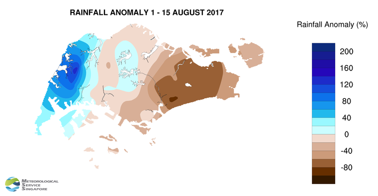
6 Compared to the second half of July 2017 where Singapore experienced several days of dry and warm conditions and with few days of rainfall, the first fortnight of August 2017 experienced wetter weather conditions. The thundery showers in the first half of August 2017 occurred between the late morning and early afternoon on most days and between the predawn and early morning on a few days. The showers were due to convergence of winds either over Singapore or in our immediate surrounding vicinity. The rain was heaviest on 6 August 2017 around the Lim Chu Kang area where the highest daily rainfall recorded was 116.8mm.
7 Although it rained on most days during the first half of the month, there were still a few warm days. The highest daily maximum temperature during the first fortnight ranged between 34.1°C and 34.4°C, and the lowest daily minimum temperature was between 21.7°C and 23.3°C. At the Changi climate station, the mean monthly temperature recorded in the first half of August 2017 was 28.2°C, which is 0.3°C higher than the long-term mean of 27.9°C for August.
8 About two-third of Singapore received below-normal rainfall in first fortnight of August 2017. The lowest rainfall of 12.4mm (48% below average) was recorded around the Tanjong Katong area. Rainfall was highest around the Choa Chu Kang area where 216.0mm (135% above average) was recorded.
CLIMATE STATION STATISTICS FOR AUGUST (Climatological reference period: 1981 – 2010)
| Mean daily maximum temperature | 31.4 °C |
| Mean daily minimum temperature | 25.0 °C |
| Mean monthly temperature | 27.9 °C |
| Mean rainfall for the month | 148.9 mm |
| Mean number of rain days | 14 |
| Highest monthly mean daily maximum temperature | 32.6 °C (1997) |
| Lowest monthly mean daily minimum temperature | 23.9 °C (1989) |
| Highest monthly rainfall | 327.3 mm (2008) |
| Lowest monthly rainfall | 45.1 mm (1994) |