The second fortnight of February 2018 expected to be warmer and wetter than the first fortnight of the month. Warm conditions with afternoon thundery showers expected for Lunar New Year weekend.
Singapore, 14 February 2018 – In the second fortnight of February 2018, the prevailing Northeast Monsoon conditions over Singapore and the region will continue to persist and extend into early March 2018. During this period, the low level winds are forecast to blow predominantly from the northeast or northwest.
2 The second half of February 2018 is forecast to be wetter than the first half of the month. Short-duration thundery showers due to strong day-time heating of land areas coupled with convergence of winds, are expected mostly in the afternoon on six to eight days. On a few of these days, the thundery showers may extend into the evening. The rainfall for February 2018 is likely to be below normal.
3 The second fortnight of February 2018 is also expected to be warmer than the first fortnight of February 2018. Some warm days can be expected where the daily maximum temperature could reach a high of around 34°C. On most days, the daily maximum temperature is forecast to be around 32°C or 33°C while the daily minimum temperature is expected to range between 23°C and 24°C.
4 For the Lunar New Year holiday period, the weather is expected to be warm with thundery showers in the afternoon, and the daily temperature is forecast to range between 24°C and 34°C.
5 For updates of the daily weather forecast, please visit the MSS website (https://www.weather.gov.sg), NEA website (www.nea.gov.sg), or download the myENV app, or the MSS’ Weather@SG app.
REVIEW (1 – 13 January 2018)
6 The Northeast Monsoon conditions prevail during the first fortnight of February 2018 with the low level winds over the region blowing predominantly from the north or northeast.
7 In the first week of February 2018, a weak monsoon surge [1] between 2 February and 5 February brought windy conditions with occasional showers on 2 February, and passing showers on subsequent days during the period. For the rest of the first fortnight, the weather was fair and occasionally windy due to the passage of a dry air mass from northern Asia. The highest total daily rainfall recorded in the first fortnight of February 2018 was 16.6mm around the Ulu Pandan area on 2 February 2018.
8 During the first two weeks of February 2018, the daily maximum temperature ranged between 29.4°C and 33.7°C, and the daily minimum temperature ranged between 22°C and 25.2°C. The lowest temperature of 22°C was recorded over Pulau Ubin on 8 and 10 February 2018.
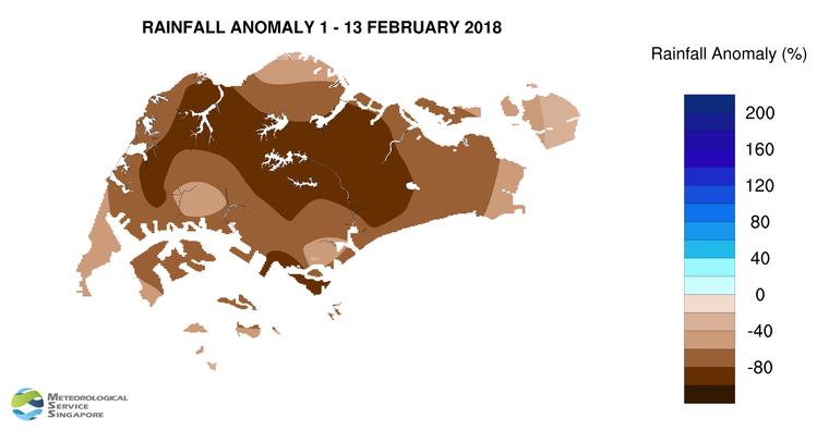
9 Singapore received well below-normal rainfall in the first two weeks of February 2018. The highest rainfall of 22.4mm (66% below average) was recorded around the south-western part of Singapore. Rainfall was lowest around the Jurong west area where 4.2mm (94% below average) was recorded.
[1] A monsoon surge refers to the strengthening of northeasterly winds blowing from a strong high-pressure system over the northern Asian continent toward the South China Sea, bringing periods of prolonged widespread rain and windy conditions to the surrounding region including Singapore and Peninsular Malaysia. (Further information is available at https://www.weather.gov.sg/learn_weather_systems/).
CLIMATE STATION STATISTICS FOR FEBRUARY (Climatological reference period: 1981 – 2010)
| Mean daily maximum temperature | 31.7 °C |
| Mean daily minimum temperature | 24.3 °C |
| Mean monthly temperature | 27.1 °C |
| Mean rainfall for the month | 112.8 mm |
| Mean number of rain days | 8 |
| Highest monthly mean daily maximum temperature | 33.5 °C (2010) |
| Lowest monthly mean daily minimum temperature | 23.0 °C (1982) |
| Highest monthly rainfall | 470.4 mm (1984) |
| Lowest monthly rainfall | 6.3 mm (2010) |