Learn | Forecasting The Weather - Weather Information Portal
- Share this page


Forecasting the weather involves a mix of technical data, analysis tools and experience, yet limitations still remain
| Weather Descriptor | Definition |
| Rain | Steady water droplets that fall from stratiform or layer clouds. Tends to affect a wide area, and is more persistent than showers. |
| Showers | Brief precipitation from cumuliform clouds. Characterised by the sudden start and end of the precipitation. Sometimes occur in spells, and usually localised over an area. |
| Thundery showers | Precipitation from cumulonimbus clouds accompanied by thunder and lightning, and sometimes strong wind gusts at the ground. Under suitable conditions can produce waterspouts and/or hail. |
| Fair | Generally sunny with few clouds in the sky. No occurrence of rain or showers. |
| Hazy | Suspension of particulate matter (e.g. dust, smoke particles) in the air, causing reduced visibility. |
| Partly Cloudy | Between 3 eighths and 4 eighths of the sky is covered by clouds. It has the same connotation as “partly sunny”, which is a mix of sun and clouds. |
| Cloudy | Between 5 eighths and 7 eighths of the sky is covered by clouds. |
| Overcast | The whole sky is completely covered by cloud, giving dull, grey conditions. |
| Description | |
| Intensity | |
| Light (or Slight) | Puddles are slow to form, and there is no or slow accumulation of water |
| Moderate | Puddles form rapidly,, and some spray visible over hard surfaces |
| Heavy | Rain/showers falling in sheets with misty spray over hard surfaces. Can cause flash floods. |
| Duration | |
| Occasional | Rain or showers occurring at irregular, infrequent intervals. |
| Intermittent | Rain occurring at irregular but frequent intervals |
| Continuous | Rain without any break or with very short breaks |
| Distribution | |
| One or two areas [1] | Small, localised part of a Region of Singapore affected by rain/showers |
| Many areas | Large parts of more than two Regions of Singapore affected by rain/showers |
| Widespread | Almost all parts or whole of Singapore affected by rain/showers |
| Time Descriptor | Period | 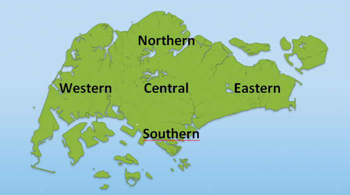 |
| Early hours | MN to 4am | |
| Pre-dawn | 4am to 6am | |
| Early morning | 6am to 9am | |
| Late morning | 9am to MD | |
| Morning | 6am to MD | |
| Early afternoon | MD to 3pm | |
| Late afternoon | 3pm to 6pm | |
| Afternoon | MD to 6pm | |
| Evening | 6pm to 8pm | |
| Night | 6pm to 6am |
[1] “One or two areas” is used only in conjunction with 1 or 2
Regions of Spore (e.g. western Spore) when a localised part of the region is
affected. Not applicable for “many areas”.
Forecasting the weather has always been a huge challenge as the intricate workings
of Mother Nature have yet to be fully understood. In the old days, weather
forecasters relied solely on physical observations and past experiences to predict
the weather. But the forecasters of today have at their disposal a larger variety of
tools to study the atmosphere and weather systems. In fact, they must be equipped
with the necessary skills to process observations and interpret data from a wide
range of sources in order to understand the current atmospheric situation before
being able to project its future state.
The first step in making a forecast would be to understand current weather
conditions. MSS receives weather observation data from meteorological stations
located around the world which are exchanged as part of the international network
co-ordinated by the World Meteorological Organization (WMO). In addition, MSS also
receives data from the weather satellites orbiting high above the earth. These
satellite images provide an aerial view showing the locations of weather systems
over the region. For higher resolution close-range monitoring, MSS relies on its
weather radar, which can detect rain-bearing clouds within a range of about 500 km
of Singapore. Other observational data which can help provide a three dimensional
view of the atmosphere would be the network of automatic and manned weather
observation stations operated by MSS, the wind profiler, lightning detection system
and the upper air sounding system.
 Global Observing System
of weather observations on the land, sea, sky and space (Image source: WMO)

International network of observation stations coordinated by the WMO report and
exchange regular weather observations for weather monitoring and forecasts
(Image source: WMO)

Numerical Weather Prediction model of total precipitation
Output from numerical weather prediction models provide useful guidance for
Meteorologists in their assessment of the future state of the atmosphere.With an
understanding of the current weather conditions, the forecaster is then in a better
position to make the forecast. The forecast is carried out based on an
understanding of the behaviour of various local and regional weather systems as well
as with help from numerical weather prediction model outputs. These numerical
models are computer simulations of the atmosphere run by leading meteorological
centres and provide forecasts of various meteorological parameters (e.g. wind,
pressure, precipitation). While these numerical models have a reasonable level of
skill in the temperate regions where weather systems tend to be larger and of longer
duration, forecasting of weather conditions in the tropics still poses a challenge
due to the transient nature and small size of the weather systems here and it is not
possible to rely fully on the numerical models. The forecaster has to make a
decision based on his understanding of meteorology, experience and the observation
data available.
Despite the huge advances in technology in recent years, Meteorologists in Singapore
are still hindered by physical constraints when forecasting the weather. First, is
the small geographical size of Singapore. Measuring just 42 km long and 22 km
wide, Singapore can barely be spotted on maps, making the task of locating local
thunderstorms an intrinsically difficult task. To use outputs from numerical weather
prediction models to predict local thunderstorms in Singapore is a huge challenge.
The resolution of these models usually ranges in the tens of kilometres and they are
therefore unable to detect small scale thunderstorms which can develop rapidly over
different parts of the island.
Compounding the difficult task of forecasting the weather for a small country is the
fact that Singapore is located just one degree north of the equator and is often in
close proximity to a volatile area of convective thunderstorm activity known as the
“Inter-Tropical Convergence Zone”. This is an area of intense thunderstorms around
the equator where the trade winds from both hemispheres meet. As such, Singapore
frequently experiences shower activities that develop and dissipate very quickly,
often in the span of 1-2 hours. This makes thunderstorm movement and development
extremely difficult to track.
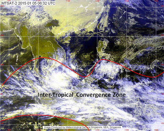 The Inter-Tropical
Convergence Zone (ITCZ), a region of intense thunderstorm development in close
proximity to Singapore.
Forecasting weather in the tropics presents its own challenges not found elsewhere.
Tropical weather systems are driven by different mechanisms as their temperate
counterparts. With most of the large and established meteorological centres located
in temperate regions, considerably fewer studies have been done to understand
weather forecasting in the tropics. The light and variable winds which predominate
the region also exacerbate the situation by making the movements of storm systems
difficult to monitor.
 Weather systems come in a
variety of scales and life spans. Singapore frequently experiences weather
systems that are small in scale and short in duration.
Weather forecasting is an evolving science with rapid advances being made in the way
weather data is collected as well as the way these data are processed to forecast
future weather events. So the next time you look up to the sky and see storm clouds
gathering, remember that a group of Meteorologists are watching the storm
development and are trying their best to give an accurate weather forecast for
Singapore.