Warm conditions expected on a few days
Singapore, 16 March 2017 – The prevailing Northeast Monsoon conditions are expected to weaken and gradually transition to inter-monsoon conditions around the last week of March 2017. The low level winds are forecast to blow from the northeast or northwest in the early part of the fortnight and become light and variable in direction with the onset of the inter-monsoon period in the later part of the month.
2 The inter-monsoon period is expected to prevail into April and May 2017. This period is characterised by warm weather and thunderstorms developing mainly in the afternoon and early evening. Light wind conditions are common during the inter-monsoon period, during which particulate matter in the atmosphere take a longer time to disperse. This may occasionally produce the appearance of slightly hazy skies over parts of Singapore on some days.
3 In the second half of March 2017, short-duration thundery showers are expected on five to seven days, mostly in the afternoon, and could extend into the evening on a few days. The thunderstorms can be heavy on some days because of strong convection due to daytime heating of land areas. In addition, widespread thundery showers accompanied by gusty winds can be expected in the morning on one or two days during the period. Overall, the rainfall for March 2017 is likely to be slightly below normal.
4 In the next fortnight, relatively warm temperatures of between 34°C and 35°C can be expected on a few days when there is strong solar heating and the winds are light. On most days, the daily maximum temperature is forecast to range between 33°C and 34°C.
5 For updates of the daily weather forecast, please visit our MSS website (https://www.weather.gov.sg), NEA website (www.nea.gov.sg), or download the myENV app, or the MSS’ Weather@SG app.
Review: 1 – 15 March 2017
6 Northeast Monsoon conditions prevailed over the region in the first fortnight of March 2017, with the low level winds blowing mainly from the northeast or northwest.
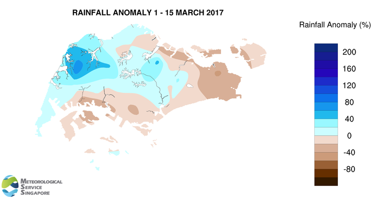
7 During the first half of March 2017, Singapore experienced thundery showers mostly in the afternoon. The showers were heaviest on the afternoon of 11 March 2017 over northwestern Singapore. The heavy thundery showers were induced by strong heating of land areas coupled with convergence of winds in the surrounding vicinity. The highest daily total rainfall recorded during the first fortnight of March 2017 was 59.9mm in the Choa Chu Kang area.
8 In the first fortnight of March 2017, the daily maximum temperatures ranged between 27.6°C and 35.7°C, and the daily minimum temperatures ranged between 22.9°C and 25.3°C.
9 About half of Singapore received above normal rainfall in the first half of March 2017. The highest rainfall of 204.6mm (80% above average) was recorded around Choa Chu Kang area. Rainfall was lowest around Changi where 47.4mm (43% below average) was recorded.
CLIMATE STATION STATISTICS FOR MARCH (Climatological reference period: 1981 – 2010)
| Mean daily maximum temperature | 32.0 °C |
| Mean daily minimum temperature | 24.6 °C |
| Mean monthly temperature | 27.5 °C |
| Mean rainfall for the month | 170.3 mm |
| Mean number of rain days | 13 |
| Highest monthly mean daily maximum temperature | 34.1 °C (1998) |
| Lowest monthlymean daily minimum temperature | 23.7 °C (1982) |
| Highest monthly rainfall | 361.3 mm (1984) |
| Lowest monthly rainfall | 34.3 mm (1997) |