More thundery showers expected in the coming fortnight
Singapore, 2 October 2017 – The prevailing Southwest monsoon conditions with low level winds blowing from the southeast or southwest, will continue into the first fortnight of October 2017. However, these conditions are forecast to gradually transit to inter-monsoon conditions around the end of the fortnight, where the prevailing winds are expected to shift to become light and variable in direction.
2 With the transition to inter-monsoon conditions around mid-October 2017, an increase in the occurrence of thundery showers can be expected in the first two weeks of the month. The thundery showers which are expected on six to eight days of the first fortnight are likely to fall mostly in the late morning and afternoon, and may extend into the evening on a few days. In addition, on two or three days during this fortnight, the eastward passage of Sumatra squalls could bring widespread thundery showers accompanied by occasional gusty winds over Singapore between the predawn hours and morning. The rainfall for the first two weeks of October 2017 is expected to be above normal.
3 The daily temperature on most days in the first two weeks of October 2017 is forecast to range between 24°C and 33°C. There could be a few days where the daily maximum temperature could reach around 34°C, and on a few rainy days, the daily minimum temperature could fall to around 22°C.
4 For updates of the daily weather forecast, please visit our MSS website (https://www.weather.gov.sg), NEA website (www.nea.gov.sg), or download the myENV app, or the MSS’ Weather@SG app.
Review: 1 – 30 September 2017
5 In September 2017, Southwest Monsoon conditions prevailed over Singapore, and the low level winds were blowing mostly from the southeast or southwest.
6 The total rainfall recorded was higher in the second half of September 2017 compared to the first half of the month. On most days of the month, Singapore experienced thundery showers in the late morning and afternoon due to strong solar heating of land areas coupled with convergence of winds over Singapore and the surrounding vicinity. On a couple of days, the thundery showers were due to the passage of Sumatra squalls that moved over Singapore in the predawn hours and early morning. The heaviest daily rainfall of 94mm was recorded on 10 September 2017 around the Sungei Kadut area.
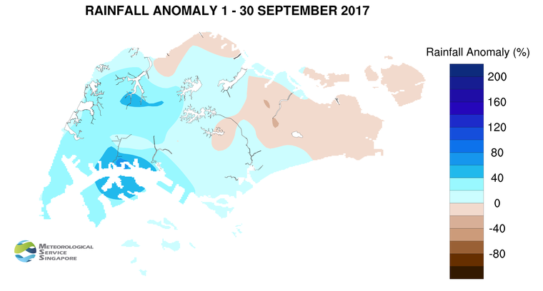
7 There were a few warm days during the month where the daily maximum temperature reached a high of between 34.1°C and 34.9°C. The lowest daily minimum temperature recorded ranged between 21.9°C and 22.9°C on a few days where it rained for most parts of the day. At the Changi climate station, the mean monthly temperature recorded for September 2017 was 28.0°C, which is 0.4°C higher than the long-term mean temperature for September.
8 Most parts of Singapore received above-normal rainfall in September 2017. The highest rainfall of 320.2mm (68% above average) was recorded around the Jurong area. Rainfall was lowest in the eastern part of the island where 124.4mm (22% below average) was recorded around the Changi area.
CLIMATE STATION STATISTICS FOR OCTOBER (Climatological reference period: 1981 – 2010)
| Mean daily maximum temperature | 31.7 °C |
| Mean daily minimum temperature | 24.7 °C |
| Mean monthly temperature | 27.6 °C |
| Mean rainfall for the month | 154.6 mm |
| Mean number of rain days | 15 |
| Highest monthly mean daily maximum temperature | 33.0 °C (2002) |
| Lowest monthly mean daily minimum temperature | 23.8 °C (1982) |
| Highest monthly rainfall | 351.4 mm (2003) |
| Lowest monthly rainfall | 10.8 mm (2002) |