Singapore, 1 September 2022 – The first fortnight of September 2022 is expected to be wet with a few warm days. The prevailing Southwest Monsoon conditions are forecast to persist over Singapore and the surrounding region, and the low-level winds are expected to blow from the southeast or southwest on most days.
2 In the first half of September 2022, the monsoon rain band is expected to lie over the equatorial Southeast Asia region. Thundery showers are forecast between the morning and early afternoon over parts of Singapore on most days. In addition, the development of low-pressure systems over the northern South China Sea could trigger Sumatra squalls over the Strait of Malacca, and bring widespread thundery showers and gusty winds to Singapore between the early and pre-dawn hours on some days. On one or two days, widespread moderate to heavy thundery showers can be expected when prevailing winds in the region converge over Singapore and the surrounding region. The total rainfall for first half of September 2022 is likely to be near average over most parts of the island.
3 During the fortnight, the daily temperature on most days is expected to range between 24 and 33 degrees Celsius. On some rainy days, the daily minimum temperature may dip to around 22 degrees Celsius. The daily maximum temperature could reach a high around 34 degrees Celsius on a few days. In addition, warm and humid conditions can be expected on a few nights when prevailing winds from the southeast or south blow warm and humid air from the sea. The minimum night-time temperatures may reach around 28 degrees Celsius, particularly over the south-eastern parts of the island.
4 For updates of the daily weather forecast, please visit the MSS website (https://www.weather.gov.sg), NEA website (www.nea.gov.sg), or download the myENV app.
REVIEW (1 – 31 August 2022)
5 In August 2022, Southwest Monsoon conditions prevailed over the region. The low-level winds blew from the southeast or southwest on most days, and from the east on a few days.
6 There were more showers in the second half of August 2022 compared to the first half of the month. The wet weather can be largely attributed to the passage of the wet phase of the Madden-Julian Oscillation (MJO) over the equatorial region. On most days in the month, moderate to heavy thundery showers affected the island in the late morning and afternoon, extending into the evening on a few days. The passage of Sumatra squalls brought widespread thundery showers with gusty winds to Singapore in the morning on several days. On 23 August 2022, large-scale convergence of winds in the surrounding vicinity brought moderate to heavy thundery showers and gusty winds over Singapore in the morning. The highest daily total rainfall recorded that day was 118.2mm at Jurong. This was the highest daily total rainfall for August 2022.
7 In August 2022, the daily maximum temperature was below 34 degrees Celsius on most days due to the rainy weather. The wet weather brought several days with cool night time temperatures. There were 20 days with daily minimum temperatures of 24 degrees Celsius or less. The lowest daily minimum temperature was 21.7 degrees Celsius recorded at Jurong on 16 August 2022. There were a few warm days mainly in the first half of August 2022, and the highest daily maximum temperature recorded in August 2022 was 35.1 degrees Celsius at Marina Barrage on 11 and 17 August 2022. On a few nights during the month, the daily minimum temperature over the southern, eastern and western coastal areas of the island were above 28 degrees Celsius.
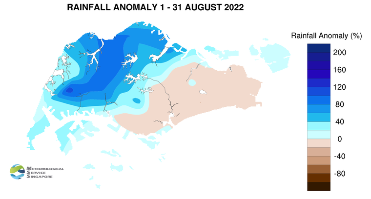
8 About two-third of Singapore experienced above average rainfall in August 2022, with most of the rain falling over the northern and western parts of Singapore. The rainfall recorded at Jurong was 115 percent above average while that recorded at Chai Chee was 21 percent below average.
CLIMATE STATION STATISTICS
Long-term Statistics for September
(Climatological reference period: 1991 – 2020)
| Average daily maximum temperature: | 31.6 °C |
| Average daily minimum temperature: | 25.2 °C |
| Average monthly temperature: | 28.0 °C |
| Average rainfall: | 124.9 mm |
| Average number of rain days: | 13 |
Historical Extremes for September
(Rainfall since 1869 and temperature since 1929)
| Highest monthly mean daily maximum temperature: | 33.0 °C (2019) |
| Lowest monthly mean daily minimum temperature: | 22.4 °C (1930) |
| Highest monthly rainfall ever recorded: | 440.4 mm (1988) |
| Lowest monthly rainfall ever recorded: | 22.8 mm (2019) |