Singapore, 16 February 2022 – The generally wet weather experienced in the first fortnight of February 2022 is expected to continue into the second half of the month, with the prevailing winds blowing from the northwest or northeast.
2 During the second half of February 2022, the monsoon rain band is forecast to lie over the equatorial Southeast Asia region and continue to bring showers to Singapore and the surrounding vicinity. Short-duration thundery showers can be expected in the afternoon on most days, extending into the evening on some occasions. On one or two days, the presence of a mass of dry air over the surrounding South China Sea may bring stable atmospheric conditions and generally fair and warm weather to Singapore.
3 In the latter half of the fortnight, the prevailing winds from the northeast are forecast to strengthen. On some days during this period, large-scale convergence of winds over Singapore and the surrounding region may trigger widespread and heavy thundery showers over the island. Overall, the rainfall for February 2022 is forecast to be above-average over most parts of the island.
4 For the rest of February 2022, the daily temperature is forecast to range between 24°C and 33°C on most days. On days with less cloud cover, the maximum temperature may reach around 34°C.
5 For updates of the daily weather forecast, please visit our MSS website (https://www.weather.gov.sg), NEA website (www.nea.gov.sg), or download the myENV app.
REVIEW (1 – 15 February 2022)
6 Northeast Monsoon conditions prevailed over Singapore and the surrounding region in the first half of February 2022. The prevailing low-level winds blew mainly from the northwest or northeast, and from the east on a few days.
7 During the first fortnight of February 2022, thundery showers fell over parts of the island in the late afternoon and evening on most days. There were also occasional showers during the night on one or two days. On 12 February 2022, strong solar heating of land areas coupled with convergence of prevailing winds with the sea breeze led to the development of moderate to heavy thundery showers over western and southern Singapore. A total of 70mm of rainfall was recorded at Jurong West that day. This was the highest daily rainfall recorded in the first half of February 2022.
8 Between 10 – 11 February 2022, the convergence of low-level winds from the northeast brought occasional spells of rain with cloudy skies and cool conditions to Singapore and the surrounding region. On 10 February 2022, the highest maximum temperature was only 26.8°C, recorded at Sentosa. On 11 February 2022, the minimum temperature dropped to a low of 22.3°C at Pulau Ubin. This was the lowest minimum temperature recorded in the first half of February 2022. The highest daily maximum temperature of 34.2°C was recorded on 4 February 2022 at Paya Lebar.
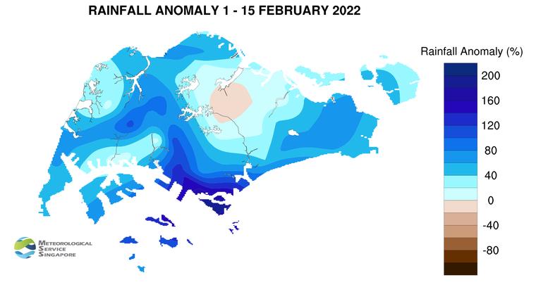
9 Above-average rainfall was recorded over most parts of the island in the first half of February 2022. The highest anomaly of 200% above-average was recorded at Sentosa. The rainfall recorded at Ang Mo Kio was 15% below-average.
CLIMATE STATION STATISTICS
Long-term Statistics for February
(Climatological reference period: 1991 – 2020)
| Average daily maximum temperature: | 31.5 °C |
| Average daily minimum temperature: | 24.6 °C |
| Average monthly temperature: | 27.3 °C |
| Average rainfall: | 105.1 mm |
| Average number of rain days: | 9 |
Historical Extremes for February
(Rainfall since 1869 and temperature since 1929)
| Highest monthly mean daily maximum temperature: | 33.5 °C (2010) |
| Lowest monthly mean daily minimum temperature: | 21.6 °C (1930, 1934) |
| Highest monthly rainfall ever recorded: | 566.7 mm (1910) |
| Lowest monthly rainfall ever recorded: | 0.2 mm (2014) |