Singapore, 16 September 2022 – The prevailing Southwest Monsoon conditions are forecast to persist over Singapore and the surrounding region in the next fortnight. During this period, the low-level winds are expected to continue blowing from the southeast or southwest.
2 In the next two weeks, short-duration thundery showers can be expected between the late morning and afternoon on most days. In the latter half of the fortnight, the convergence of winds over the region may influence the development of Sumatra squalls and bring widespread thundery showers and gusty winds over Singapore on a few mornings. Overall, more rainfall is expected in the second half of September 2022 compared to the first half of the month. The overall rainfall for September 2022 will likely be near normal over most parts of the island.
3 During the fortnight, the daily temperature on most days is forecast to range between 24 degrees Celsius and 33 degrees Celsius. There may be a few warm days, particularly in the first half of the fortnight, when maximum temperatures could reach around 34 degrees Celsius.
4 For updates of the daily weather forecast, please visit the MSS website (https://www.weather.gov.sg), NEA website (www.nea.gov.sg), or download the myENV app.
REVIEW (1 – 15 September 2022)
5 In the first fortnight of September 2022, Southwest Monsoon conditions prevailed over Singapore and the surrounding region with the low-level winds blowing mostly from the southeast or southwest.
6 During this period, the monsoon rain band was mostly situated over the northern Southeast Asia region, resulting in less wet weather over equatorial Southeast Asia including Singapore. Short-duration thundery showers fell over parts of Singapore in the afternoon on some days. On a few mornings, large-scale convergence of winds over Singapore and the surrounding region brought widespread moderate to heavy thundery showers. The highest daily total rainfall for the first half of September 2022 occurred on 13 September 2022, when 92.2 mm of rain fell around the West Coast Road area in the morning.
7 During the first half of September 2022, the daily maximum temperature ranged from 30.7 degrees Celsius to 34.4 degrees Celsius. The highest daily maximum temperature of 34.4 degrees Celsius was recorded at Paya Lebar on 12 September 2022.
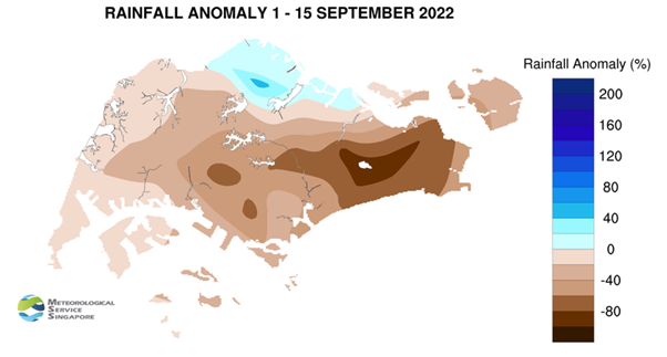
8 The rainfall was below average for many parts of the island in the first fortnight of 2022. The highest rainfall anomaly of 53 percent above average was recorded at Sembawang. The anomaly was lowest at Simei at 89 percent below average.
CLIMATE STATION STATISTICS
Long-term Statistics for September
(Climatological reference period: 1991 – 2020)
| Average daily maximum temperature: | 31.6 °C |
| Average daily minimum temperature: | 25.2 °C |
| Average monthly temperature: | 28.0 °C |
| Average rainfall: | 124.9 mm |
| Average number of rain days: | 13 |
Historical Extremes for September
(Rainfall since 1869 and temperature since 1929)
| Highest monthly mean daily maximum temperature: | 33.0 °C (2019) |
| Lowest monthly mean daily minimum temperature: | 22.4 °C (1930) |
| Highest monthly rainfall ever recorded: | 440.4 mm (1988) |
| Lowest monthly rainfall ever recorded: | 22.8 mm (2019) |