Fortnightly Weather Outlook for 15 – 31 December 2020
Singapore, 15 December 2020 – The weather in the second fortnight of December 2020 is forecast to be less wet compared to the first fortnight of the month. During the coming fortnight, the prevailing Northeast Monsoon conditions are expected to persist and the low-level winds over Singapore are forecast to continue blowing from the northwest or northeast.
2 In the second fortnight of December 2020, the north-easterly winds over the South China Sea and Singapore are forecast to weaken. During this period, short-duration thundery showers due to strong day-time heating of land areas coupled with localised convergence of winds in the surrounding vicinity, are expected over parts of the island in the afternoon on most days. The showers may extend into the evening on a few days. Also in the fortnight, a brief strengthening of northerly winds can be expected. This could bring windy conditions with occasional showers on one or two days. Overall, the rainfall for December 2020 is expected to be below average over most parts of the island.
3 In the coming fortnight, the daily temperature on most days is forecast to range between 24°C and 33°C. Warm conditions with maximum day-time temperatures of around 34°C in the afternoon can be expected on days when there is little or no rainfall.
4 For updates of the daily weather forecast, please visit our MSS website (https://www.weather.gov.sg), NEA website (www.nea.gov.sg), or download the MSS’ Weather@SG app, and/or the myENV app.
REVIEW (1 – 14 December 2020)
5 Northeast Monsoon conditions prevailed in the first half of December 2020 with low-level winds blowing from the northwest or northeast on most days.
6 During the first two weeks of December 2020, strong solar heating of land areas coupled with localised convergence of winds brought short-duration moderate to heavy thundery showers over the island on most days. The showers fell mostly in the afternoon, and on few days, extended into the evening. The heavy thundery showers that fell over many areas of the island on 14 December 2020 recorded a daily total rainfall of 94.0mm at Choa Chu Kang. This was the highest total rainfall in a day for the first half of December 2020.
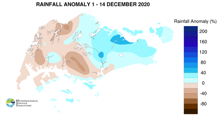
7 In the first half of December 2020, the daily temperature ranged between 22.4°C and 34.4°C. The highest daily maximum temperature recorded was 34.4°C on 8 December 2020 at Paya Lebar. The daily minimum temperature on most days ranged between 23°C and 24°C, and the lowest minimum temperature recorded during the period was 22.4°C on 11 December 2020 at Sembawang.
8 About half of the island recorded below average rainfall in the first half of December 2020. The highest anomaly of 56% below average was recorded at Admiralty. The rainfall recorded at Pasir Ris was 55% above average.
CLIMATE STATION STATISTICS
Long-term Statistics for December
(Climatological reference period: 1981 – 2010)
| Average daily maximum temperature | 30.2 °C |
| Average daily minimum temperature | 24 °C |
| Average monthly temperature | 26.4 °C |
| Average rainfall | 318.6 mm |
| Average number of rain days | 18 |
Historical Extremes for December
(Rainfall since 1869 and temperature since 1929)
| Highest monthly mean daily maximum temperature: | 31.6 °C (2016, 2018) |
| Lowest monthly mean daily minimum temperature: | 21.9 °C (1933) |
| Highest monthly rainfall ever recorded: | 765.9 mm (2006) |
| Lowest monthly rainfall ever recorded: | 62.5 mm (1932) |