Singapore, 17 October 2022 – The current wet weather is expected to continue for the rest of October 2022. The prevailing Southwest Monsoon conditions, with low-level winds blowing from the southeast or west, are forecast to gradually weaken to become light and variable in direction by the end of October 2022. The shift in wind conditions signals the end of the Southwest Monsoon and the start of the inter-monsoon period.
2 The inter-monsoon conditions are forecast to last through November 2022. During the inter-monsoon period, the monsoon rain band lies close to the equatorial region, and more showers can be expected over Singapore and the surrounding vicinity. Lightning activity tends to be higher during the inter-monsoon months than other months of the year.
3 In the coming fortnight, thundery showers are expected on most days. On some days in the earlier half of the fortnight, the presence of low-pressure systems over the South China Sea may induce the development of Sumatra squalls in the Strait of Malacca and bring widespread thundery showers with gusty winds to Singapore and the surrounding vicinity between the pre-dawn hours and morning. In the latter half of the fortnight, afternoon thundery showers are forecast on most days, with the showers extending into the evening on a few of these days. On a few days, widespread moderate to heavy thundery showers may occur, due to large-scale convergence of winds over Singapore and the surrounding region. Overall, the rainfall for October 2022 is expected to be well above-average over most parts of Singapore.
4 For the rest of October 2022, the daily temperature on most days is forecast to range between 24 degrees Celsius and 33 degrees Celsius. Although showers are expected on most days in the coming fortnight, the daily maximum temperature could still reach a high of around 34 degrees Celsius on a few days. In addition, the wet weather may bring daily temperatures of between 23 and 32 degrees Celsius on a few days.
5 For updates of the daily weather forecast, please visit the MSS website (https://www.weather.gov.sg), NEA website (www.nea.gov.sg), or download the myENV app.
REVIEW (1 – 16 October 2022)
6 In the first fortnight of October 2022, Southwest Monsoon conditions continued to persist in the region with the low-level winds blowing mostly from the southeast or southwest, and from the west on some days.
7 During the period, the influence of several tropical storms over the South China Sea and Western Pacific Ocean resulted in large-scale convergence of winds over Singapore and the surrounding vicinity. This likely led to the development of several Sumatra squalls that brought widespread showers and gusty winds over Singapore between the pre-dawn hours and morning on most days. Thundery showers also fell over the island on a few nights. The Sumatra squall which brought heavy thundery showers over many parts of Singapore on the morning of 5 October 2022 resulted in a daily total rainfall of 138.1 mm recorded at Pasir Panjang. This was the highest rainfall recorded in a day in the first half of October 2022.
8 The Sumatra squalls brought cloudy and cool conditions on most days in the first fortnight of October 2022. There were 11 days during the review period when the daily maximum temperature was lower than 33 degrees Celsius. The wet weather also brought several days with cool night-time temperatures. There were nine days with daily minimum temperatures of 23 degrees Celsius or less. The temperature at Jurong Island dropped to 21.9 degrees Celsius during the showers on 12 October 2022. That was the lowest daily minimum temperature for the first half of October 2022.
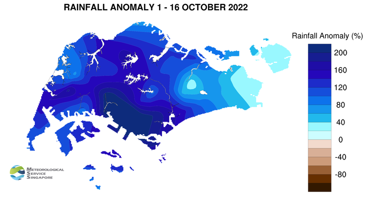
9 Well above-average rainfall was received across the island in the first fortnight of October 2022. The highest anomaly of 318 percent above-average was recorded around the Kent Ridge area. The anomaly was lowest at Paya Lebar at 19 percent above-average.
CLIMATE STATION STATISTICS
Long-term Statistics for October
(Climatological reference period: 1991 – 2020)
| Average daily maximum temperature: | 31.8 °C |
| Average daily minimum temperature: | 25.0 °C |
| Average monthly temperature: | 27.9 °C |
| Average rainfall: | 168.3 mm |
| Average number of rain days: | 15 |
Historical Extremes for October
(Rainfall since 1869 and temperature since 1929)
| Highest monthly mean daily maximum temperature: | 33.0 °C (2002) |
| Lowest monthly mean daily minimum temperature: | 22.8 °C (1964) |
| Highest monthly rainfall ever recorded: | 497.1 mm (1942) |
| Lowest monthly rainfall ever recorded: | 10.8 mm (2002) |