Thundery showers mostly in the late morning and afternoon
Singapore, 2 May 2017 – The prevailing inter-monsoon conditions where low level winds are generally light and variable in direction are expected to persist in May 2017. Some warm days and thundery showers occurring mostly in the afternoon are common in the month of May due to the strong daytime heating of land areas.
2 In the first fortnight of May 2017, the prevailing winds are forecast to be light and variable in direction on most days. On some days, with the presence of low pressure systems in the nearby region, a temporary shift in the prevailing winds to blow from the southwest or west can be expected. During this period, short-duration thundery showers are forecast mostly in the late morning and afternoon on six or seven days, and could extend into the evening on a few of these days. On two or three days in the first fortnight, widespread thundery showers and gusty winds due to Sumatra squalls can be expected between the predawn and early morning. Overall, the rainfall for the first half of May 2017 is forecast to be slightly above normal.
3 Based on long-term statistics, May is the second warmest month of the year after April. In the first two weeks of May 2017, the daily temperature on most days is expected to range between 25°C and 34°C. Warm temperatures of between 34°C and 35°C are expected on some days when there is strong solar heating and the winds are light.
4 For updates of the daily weather forecast, please visit our MSS website (https://www.weather.gov.sg), NEA website (www.nea.gov.sg), or download the myENV app, or the MSS’ Weather@SG app.
Review: 1 – 30 April 2017
5 Inter-monsoon conditions prevailed in the region in April 2017, with low level winds that were predominantly light and variable in direction.
6 During the month, Singapore experienced thundery showers mostly in the afternoon due to strong daytime heating of land areas coupled with convergence of winds in the surrounding vicinity. The occurrence of Sumatra squalls on several days in April 2017 brought widespread thundery showers and gusty winds over Singapore between the pre-dawn hours and the early morning. The heaviest rainfall recorded for April 2017 was from a Sumatra squall that brought 102mm of rain in a day. This occurred over the Tuas area on the morning of 21 April 2017.
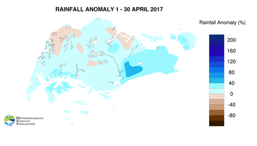
7 At the Changi climate station in April 2017, it rained on 22 days[1] and the mean temperature recorded was 27.8°C. This is two days more and 0.2°C cooler than the long-term record number of rain days and mean temperature respectively for April. There were several warm days in April 2017 where the daily maximum temperature on these days ranged from 34.1°C to a high of 35.2°C.
8 Most parts of Singapore received above normal rainfall in April 2017. The highest rainfall of 358.4mm (55% above average) was recorded around the Paya Lebar area. Rainfall was lowest around Seletar where 205.2mm (11% below average) was recorded.
[1] A day is considered to have ‘rained’ if the total rainfall for that day is 0.2mm or more.
CLIMATE STATION STATISTICS FOR MAY (Climatological reference period: 1981 – 2010)
| Mean daily maximum temperature | 32.2 °C |
| Mean daily minimum temperature | 25.4 °C |
| Mean monthly temperature | 28.3 °C |
| Mean rainfall for the month | 171.2 mm |
| Mean number of rain days | 14 |
| Highest monthly mean daily maximum temperature | 33.6 °C (1997) |
| Lowest monthly mean daily minimum temperature | 24.5 °C (1981.1982.1984,1989) |
| Highest monthly rainfall | 370.8 mm (1998) |
| Lowest monthly rainfall | 41.6 mm (1997) |