Fortnightly Weather Outlook for 28 February – 15 March 2020
Singapore, 28 February 2020 – For the first fortnight of March 2020, warm conditions are forecast on most days, and the prevailing Northeast Monsoon is expected to persist and gradually weaken around the end of the fortnight. During the period, the low-level winds are forecast to blow from the northwest or northeast and weaken in the later part of the fortnight.
2 In the early part of the fortnight, a dry air mass forecast over the equatorial Southeast Asia region is expected to bring generally dry and warm conditions over Singapore and the surrounding region on most days. From the middle of the fortnight, the winds are forecast to weaken, and short-duration thundery showers can be expected mostly in the afternoon over parts of the island on some days. The showers may be heavy on a few days when there is strong wind convergence over Singapore and the surrounding vicinity. Overall, the rainfall for the first fortnight of March 2020 is forecast to be below normal over most parts of Singapore.
3 With the expected warm weather, the daily temperature on most days during the fortnight is forecast to be between 24°C and 34°C. On a few days with light winds and few clouds, the daily maximum temperature could climb to a high of around 35°C.
4 For updates of the daily weather and haze situation, please visit the MSS website (https://www.weather.gov.sg), NEA website (www.nea.gov.sg), or download the myENV app, MSS’ Weather@SG app, and the haze microsite (www.haze.gov.sg).
REVIEW (1 – 27 February 2020)
5 The Northeast Monsoon conditions prevailed over Singapore and the surrounding region in February 2020.
6 During the month, it was windy on most days with winds blowing from the north or northeast. The monsoon rain band remained south of the Equator, and little or no rain fell over the island in the first week of February 2020. On most days for the rest of the month, occasional brief showers fell over parts of the island. On a few days in February 2020, strong daytime heating of land areas coupled with converging winds over the island brought moderate to heavy thundery showers over many areas between the afternoon and evening. The highest daily total rainfall of 108.8mm for February 2020 (as at 27 February 2020) was recorded at Tuas on 10 February 2020 following a heavy downpour in the late afternoon and evening.
7 Singapore’s daily maximum temperature in February 2020 (as at 27 February 2020) ranged from 31.0°C to 35.5°C. The highest daily maximum temperature of 35.5°C was recorded on 16 February 2020 at Admiralty. The lowest daily maximum temperature of 31.0°C was recorded on 11 February 2020 when widespread thundery showers fell over the island from the late morning to the early hours of 12 February 2020. The daily minimum temperature was between 22.8°C and 25.2°C.
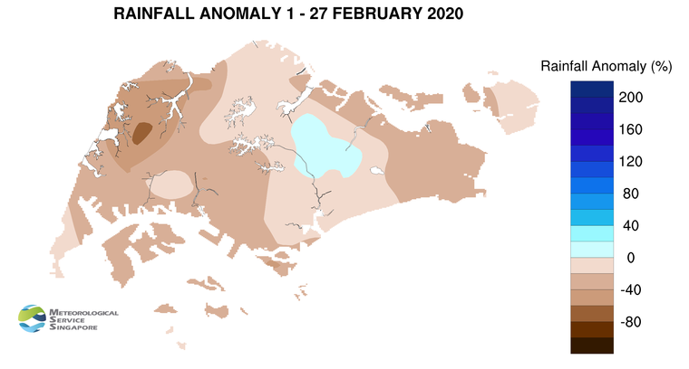
8 At the Changi climate station, the mean monthly temperature for February 2020 (as at 27 February 2020) was 27.8°C. This is 0.7°C higher than February’s long-term average temperature. In addition, the average daily wind speed recorded at the station in February 2020 was 13.0 km/hr (as at 27 February 2020). This could make February 2020, together with February 1987 and 2010, the second windiest February on record since continuous wind records commenced in 1984. The windiest February on record occurred in 2014, with an average daily wind speed of 13.7 km/h.
9 Most parts of the island recorded below-normal rainfall in February 2020. The highest anomaly of 68% below-average was recorded at Choa Chu Kang. The rainfall recorded over Paya Lebar was 14% above-average.
CLIMATE STATION STATISTICS
Long-term Statistics for March
(Climatological reference period: 1981 – 2010)
| Average daily maximum temperature | 32.0 °C |
| Average daily minimum temperature | 24.6 °C |
| Average monthly temperature | 27.5 °C |
| Average rainfall | 170.3 mm |
| Average number of rain days | 13 |
Historical Extremes for March
(Rainfall since 1869 and temperature since 1929)
| Highest monthly mean daily maximum temperature: | 34.1 °C (1998) |
| Lowest monthly mean daily minimum temperature: | 22.1 °C (1934) |
| Highest monthly rainfall ever recorded: | 528.3 mm (1913) |
| Lowest monthly rainfall ever recorded: | 6.2 mm (2016) |