Singapore, 15 May 2020 – The current warm and humid weather is forecast to continue into the second fortnight of May 2020. Towards the end of the month, more warm nights can be expected with the onset of the Southwest Monsoon. During this period, daily maximum temperatures ranging between 34.0°C and 35.0°C are expected on most days. With the presence of the monsoon rain band over the equatorial Southeast Asia region, the coming fortnight is also expected to be as wet as the first half of this month.
2 In the second fortnight of May 2020, the prevailing low-level winds which are light and variable in direction are forecast to gradually strengthen and blow from the southeast or southwest towards the end of the month. This signals the cessation of the inter-monsoon period and the start of the Southwest Monsoon season. The Southwest Monsoon season typically extends into September and is a generally drier season compared to other times of the year.
3 On most days in the second half of May 2020, short-duration moderate to heavy thundery showers can be expected between the late morning and afternoon, with showers extending into the evening on a few days. Widespread thundery showers with gusty winds due to Sumatra squalls are expected between the predawn hours and morning on two or three days. Overall, the rainfall for May 2020 is forecast to be above-average for most parts of Singapore.
4 For the rest of the month, the daily temperature on most days is expected to range between 26°C and 34°C. and reach a high of around 35°C on a few days. Towards the end of the month, the weather during the night can be warm and humid as well when prevailing winds blow from the southeast, bringing warm and humid air from the sea over the land. Temperatures of around 28°C can be expected on some nights.
5 For updates of the daily weather and haze situation, please visit the MSS website (https://www.weather.gov.sg), NEA website (www.nea.gov.sg), or download the myENV app, MSS’ Weather@SG app, and the haze microsite (www.haze.gov.sg).
REVIEW (1 – 14 May 2020)
6 Inter-monsoon conditions prevailed over the region in the first fortnight of May 2020, and the low-level winds were generally light and variable in direction. On some days, the prevailing winds blew from the southwest or west due to the influence of low-pressure systems over the South China Sea and Indian Ocean.
7 On most days in the first half of May 2020, there were moderate to heavy thundery showers in the afternoon due to strong solar heating of land areas coupled with convergence of winds over Singapore and the surrounding vicinity. On a few dayswidespread thundery showers and gusty winds to Singapore between the pre-dawn hours and morning. On 8 May 2020, heavy thundery showers from a Sumatra squall fell over many parts of Singapore in the early and predawn hours. The daily total rainfall of 67.0mm recorded at Pasir Ris that day was the highest daily total for the first half of May 2020.
8 The warm weather in April 2020 continued into the first half of May 2020. During this period, the daily maximum temperature exceeded 34°C on several days. The highest temperature of 35.3°C was recorded at Newton on 5 May 2020. There were also a few warm nights where the night-time temperature remained around 28°C at various stations, mostly in the southern and eastern parts of the island.
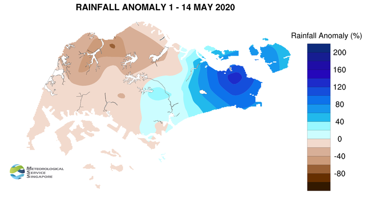
9 In the first fortnight of May 2020, the eastern half of Singapore received above-average rainfall, while the western half of the island received below-average rainfall. The rainfall recorded at Admiralty was 67% below-average while that recorded at Changi was 133% above-average.
CLIMATE STATION STATISTICS
Long-term Statistics for May
(Climatological reference period: 1981 – 2010)
| Average daily maximum temperature | 32.2 °C |
| Average daily minimum temperature | 25.4 °C |
| Average monthly temperature | 28.3 °C |
| Average rainfall | 171.2 mm |
| Average number of rain days | 14 |
Historical Extremes for May
(Rainfall since 1869 and temperature since 1929)
| Highest monthly mean daily maximum temperature: | 33.6 °C (1997) |
| Lowest monthly mean daily minimum temperature: | 23.5 °C (1974) |
| Highest monthly rainfall ever recorded: | 386.6 mm (1892) |
| Lowest monthly rainfall ever recorded: | 41.6 mm (1997) |