Fortnightly Weather Outlook for 14 – 31 June 2019
Singapore, 14 June 2019 – The prevailing Southwest Monsoon conditions are forecast to persist over Singapore and the surrounding region for the rest of June 2019, and extend to October 2019. During this period, the prevailing winds are expected to blow from the southeast or southwest.
2 In the second fortnight of June 2019, the monsoon rain band is forecast to remain over the equatorial region before shifting northwards in the last week of June 2019. Singapore can expect the wet and humid conditions experienced in the first fortnight of June 2019 to extend into the early part of the coming fortnight. A transition to dry and warm conditions is expected towards the end of June 2019. With the possible onset of the traditional dry season over Singapore and the southern Southeast Asia region in July 2019, the dry and warm conditions are likely to persist for the rest of the Southwest Monsoon season.
3 In the second half of June 2019, Singapore can expect thundery showers mostly in the late morning and early afternoon on four to six days. On some of these days, the showers could extend into the late afternoon and evening. On two or three days, Sumatra squalls could bring widespread thundery showers with gusty winds to the island between predawn and morning. Overall, the rainfall for June 2019 is likely to be slightly above-normal for most parts of Singapore.
4 In the coming fortnight, the daily temperature on most days is forecast to range between 25°C and 33°C. The daily maximum temperature could reach up to 35°C in the last week of the month. Warm and humid nights can be expected with night-time temperatures of up to 28°C on some days, in particular when prevailing winds blowing from the southeast bring in warm and humid air from the sea.
5 For updates of the daily weather forecast, please visit our MSS website (https://www.weather.gov.sg), NEA website (www.nea.gov.sg), or download the myENV app, or the MSS’ Weather@SG app.
REVIEW (1 – 13 June 2019)
6 In the first fortnight of June 2019, the light and variable winds over Singapore and the surrounding region strengthened to blow from the southeast or southwest. This shift in winds in early June 2019 signalled the end of the inter-monsoon period and the start of the Southwest Monsoon season.
7 In the first half of June 2019, the presence of the monsoon rain band over the equatorial region and the passage of the Madden-Julian Oscillation (MJO)[1] which enhanced the development of thunderstorm clouds over the region, brought generally wet weather over Singapore. Most of the thundery showers fell in the late morning and early afternoon due to large-scale wind convergence over the surrounding vicinity. The island-wide moderate to heavy thundery showers in the late morning and early afternoon on 3 June 2019 recorded the highest daily total rainfall of 102.8mm at Bukit Merah.
8 The first half of June 2019 was not as warm compared to May 2019 where maximum temperatures of above 34°C were recorded on most days. In the first half of June 2019, the daily maximum temperature ranged between 28.2°C and 33.9°C. The highest daily maximum temperature of 33.9°C was recorded at Choa Chu Kang and Pulau Ubin on 11 June 2019. There were a few warm nights where the night-time minimum temperature was around 28°C, recorded over the southern and eastern parts of the island. The warm nights were due to prevailing winds blowing from the southeast bringing warm, humid air from the sea over the land.
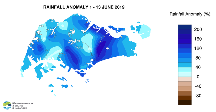
9 Well above-average rainfall was received across the island in the first fortnight of June 2019. The highest anomaly of 161% above-average was at Paya Lebar. The anomaly was lowest at Choa Chu Kang at 5% above-average.
[1] The MJO is characterised by an eastward propagation of clouds and rainfall over the tropical regions from the Indian Ocean to the western Pacific Ocean, with a period of between 30 and 60 days on average. The MJO consists of two phases – an enhanced rainfall (convection) phase and a suppressed rainfall phase.
CLIMATE STATION STATISTICS
Long-term Statistics for June
(Climatological reference period: 1981 – 2010)
| Average daily maximum temperature | 32.0 °C |
| Average daily minimum temperature | 25.4 °C |
| Average monthly temperature | 28.3 °C |
| Average rainfall | 130.7 mm |
| Average number of rain days | 12 |
Historical Extremes for June
(Rainfall since 1869 and temperature since 1929)
| Highest monthly mean daily maximum temperature: | 33.2 °C (1997) |
| Lowest monthly mean daily minimum temperature: | 23.2 °C (1965) |
| Highest monthly rainfall ever recorded: | 378.7 mm (1954) |
| Lowest monthly rainfall ever recorded: | 21.8 mm (2009) |