Fortnightly Weather Outlook for 16 – 31 August 2019
Singapore, 16 August 2019 – The prevailing Southwest Monsoon conditions are forecast to persist over Singapore and the surrounding region for the rest of August 2019, and extend into October 2019. During this period, the prevailing winds are forecast to blow mostly from the southeast or southwest.
2 In the second fortnight of August 2019, dry conditions are forecast on most days as dry air from high pressure systems over northern Australia extends to the equatorial region. Singapore has been experiencing a dry spell [1] since 31 July 2019. With thundery showers expected in the late morning and early afternoon on four or five days toward the last week of August 2019, the showers will bring some respite to the current dry spell. On some days, breezy conditions can be expected due to the occasional strengthening of winds over the equatorial region. Rainfall for the month is expected to be significantly below normal.
3 The rest of August 2019 is expected to be warm. On most days, the daily temperature is forecast to range between 26°C and 34°C, with highs of around 35°C on a few days. The minimum temperature on some nights can hover around 28°C, when prevailing winds blowing from the southeast bring in warm and humid air from the surrounding seas.
4 The dry weather in the surrounding region is forecast to persist. Hotspots with smoke plumes continue to be observed in various parts of Sumatra and Kalimantan. Depending on the direction of the prevailing winds and location of the fires, Singapore may experience occasional haze.
5 For updates of the daily weather forecast, please visit our MSS website (https://www.weather.gov.sg), NEA website (www.nea.gov.sg), or download the myENV app, or the MSS’ Weather@SG app.
REVIEW (1 – 15 August 2019)
6 During the first fortnight of August 2019, Southwest Monsoon conditions prevailed with the low level winds blowing from the southeast or southwest.
7 The dry weather prevailing in Singapore and the surrounding region since late July 2019 persisted in the first half of August 2019. Singapore experienced a dry spell [1] of 16 consecutive days between 31 July and 15 August 2019. While brief localised showers fell on some days, most parts of Singapore were dry with about 90% of all stations island-wide recording daily rainfall below 0.2 mm. The last recorded dry spell in Singapore lasted 27 days from 17 February to 15 March 2014. The extended dry weather can be attributed to an intrusion of dry air from northern Australia coupled with suppressed raincloud formation due to cooler sea surface temperatures over the tropical eastern Indian Ocean (positive phase of Indian Ocean Dipole (IOD)[2]).
8 The dry weather also contributed to a very warm first half of August 2019, with the daily maximum temperature ranging between 31.9°C and 34.5°C. The highest temperature of 34.5°C was recorded at Marina Barrage on 13 August 2019. The nights were generally warm with daily minimum temperatures above 26°C recorded over most parts of Singapore. There were a few nights where the temperature remained around 28°C in the southern and eastern coastal areas of Singapore.
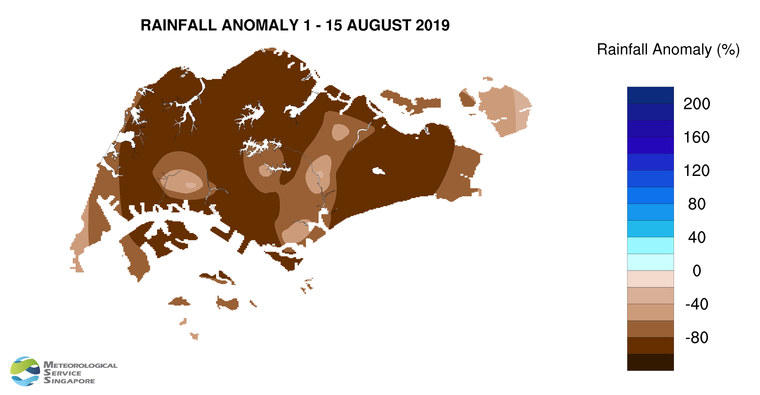
9 In the first fortnight of August 2019, significantly below-average rainfall was recorded at all stations across the island. The rainfall anomaly was close to 100% below-average for many parts of Singapore.
[1] A dry spell is defined as a period of at least 15 consecutive days with daily total rainfall of less than 1.0 mm, averaged over rainfall stations with long-term records across the island.
[2] The Indian Ocean Dipole (IOD) refers to the sustained change to the difference between sea surface temperatures (SSTs) of the tropical western and eastern Indian Ocean. The IOD varies between three phases – positive, negative and neutral. A positive (negative) phase occurs when cooler (warmer) SSTs develop in the eastern Indian Ocean, resulting in below (above) normal rainfall in the eastern Indian Ocean and the surrounding region. More information on the IOD can be found at https://www.weather.gov.sg/LEARN_climate/.
CLIMATE STATION STATISTICS
Long-term Statistics for August
(Climatological reference period: 1981 – 2010)
| Average daily maximum temperature | 31.4 °C |
| Average daily minimum temperature | 25.0 °C |
| Average monthly temperature | 27.9 °C |
| Average rainfall | 148.9 mm |
| Average number of rain days | 14 |
Historical Extremes for August
(Rainfall since 1869 and temperature since 1929)
| Highest monthly mean daily maximum temperature: | 32.6 °C (1997) |
| Lowest monthly mean daily minimum temperature: | 23.0 °C (1962) |
| Highest monthly rainfall ever recorded: | 526.8 mm (1878) |
| Lowest monthly rainfall ever recorded: | 18.0 mm (1888) |

