Category Archives: News

November 1, 2016

Inter-monsoon Conditions to Prevail in November 2016

Expect more thundery showers in the next fortnight

Singapore, 1 November 2016 – Singapore and the surrounding region are currently experiencing Inter-monsoon conditions which are expected to prevail during the first fortnight of November 2016. The Inter-monsoon period is characterised by an increase in the occurrence of showers, heavy at times, over Singapore, and winds that are mostly light and variable in direction.

2          For the first half of November 2016, short-duration thundery showers are expected on five or six days, mostly in the afternoon and could extend into the evening. In addition, widespread thundery showers accompanied by gusty winds are expected on three or four days between the predawn and early morning. November is climatologically the second wettest month of the year after December. In the first fortnight of November 2016, rainfall is expected to be slightly above normal.

3         In the coming fortnight, the maximum daily temperature on most days is forecast to be around 32°C or 33°C, and on a few days could reach a high of around 34°C.

4        For updates of the daily weather and haze forecast, please visit our MSS website (https://www.weather.gov.sg), NEA website (www.nea.gov.sg), the haze microsite (www.haze.gov.sg) or download the myENV app, MSS’ Weather@SG app.

Review: 1 – 31 October 2016

5          Southwest Monsoon conditions prevailed in the region for most parts of October 2016, before transitioning to Inter-monsoon conditions in the last week of the month. In October 2016, the low level winds were mostly blowing from the southwest or west.

6          Compared with the first half of October 2016, Singapore experienced fewer warm days in the second half of the month due to more frequent rain showers in the region. The daily maximum temperature for October 2016 ranged between 29.3°C and 34.6°C. At the Changi climate station, the mean monthly temperature recorded for October 2016 was 28.4°C, which is 0.8°C warmer than the long-term mean for October.

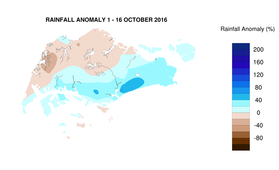
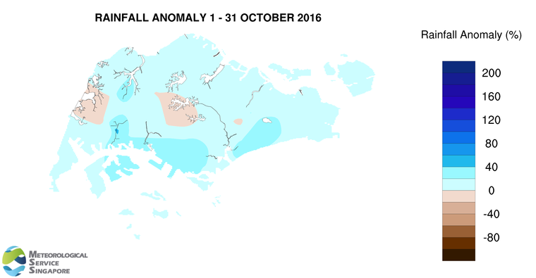
7          In October 2016, thundery showers occurred mostly in the late morning and afternoon due to strong solar heating of land areas coupled with the convergence of winds over Singapore and the surrounding vicinity. On several days during the period, the occurrence of Sumatra squalls brought moderate to heavy thundery showers to many parts of Singapore in the pre-dawn hours and early morning. The heaviest daily rainfall of 96.8mm was recorded on 3 October 2016 around Buona Vista.

8         Most parts of Singapore received above normal rainfall in October 2016. The highest rainfall of 328mm (46% above average) was recorded around Boon Lay area. Rainfall was lowest around Upper Thomson where 188.8mm (11% below average) was recorded.

FortnightRain_Anomaly_201610b

CLIMATE STATION STATISTICS FOR NOVEMBER (Climatological reference period: 1981 – 2010)

Mean daily maximum temperature 31.1 °C
Mean daily minimum temperature 24.3 °C
Mean monthly temperature 27.0 °C
Mean rainfall for the month 258.5 mm
Mean number of rain days 18
Highest monthly mean daily maximum temperature 32.0 °C (1997)
Lowest monthlymean daily minimum temperature 23.6 °C (1981,1983,1991)
Highest monthly rainfall 508.4 mm (1989)
Lowest monthly rainfall 53.5 mm (1981)


October 17, 2016

Onset of Inter-Monsoon Conditions By End-October 2016

Expect some warm days in the next fortnight

Singapore, 17 October 2016 – The prevailing Southwest Monsoon is expected to weaken toward the end of October 2016 as the region enters the Inter-Monsoon period. During the coming two weeks, the low level winds are forecast to blow from the southwest before becoming light and variable in direction towards end of the month. Inter-Monsoon conditions are characterised by light and variable winds in the surrounding region.

2        In the second fortnight of October 2016, short-duration thundery showers can be expected on four to six days, mostly in the late morning and early afternoon. In addition, widespread thundery showers with occasional gusty winds are forecast on two or three days between the pre-dawn hours and morning. Rainfall for October 2016 is expected to be slightly below normal.

3        During the period, the maximum daily temperature on most days is forecast to be around 33 or 34°C, and on a few days could reach a high of around 35°C. Warmer conditions are common during the Inter-Monsoon season when there is strong solar heating and the winds are generally light.

4        For updates of the daily weather and haze forecast, please visit our MSS website (https://www.weather.gov.sg), NEA website (www.nea.gov.sg), the haze microsite (www.haze.gov.sg) or download the myENV app, MSS’ Weather@SG app.

REVIEW: 1 – 16 October 2016

5         In the first fortnight of October 2016, Southwest Monsoon conditions prevailed over the region with the low level winds blowing predominantly from the west, and occasionally from the southwest. The prevailing winds during the review period were partly influenced by the presence of tropical storms in the northwestern Pacific Ocean and northern South China Sea.

6        Singapore experienced a few warm days in the first two weeks of October 2016. At the Changi climate station, the highest daily maximum temperature recorded was 34.6°C (on 11 October 2016). This record ties with the highest ever recorded daily maximum temperature for October (on 29 October 2002). As of 16 October 2016, the mean monthly temperature for October 2016 was 28.8°C, 1.2°C warmer than the long-term mean for October.

7        During the review period, Singapore’s rainfall on most days were from an eastward moving line of thunderstorms known as Sumatra squalls that developed over the western coast of Sumatra or the Strait of Malacca overnight. On the other days that rained, the thundery showers in the late morning and early afternoon were due to strong solar heating of land areas. Rainfall was heaviest on 3 October 2016 over the Buona Vista area where a total of 96.8mm of rainfall was recorded.

8       For the first fortnight of October 2016, rainfall was below average in the northwestern half of Singapore, and above average in the southeastern half of the island. The highest rainfall of 139.2mm (53% above average) was recorded around the Tanjong Katong area. Rainfall was lowest in the western part of the island around the Choa Chu Kang area where 65.8mm (39% below average) was recorded.FortnightRain_Anomaly_201610a

CLIMATE STATION STATISTICS FOR OCTOBER (Climatological reference period: 1981 – 2010)

Mean daily maximum temperature 31.7 °C
Mean daily minimum temperature 24.7 °C
Mean monthly temperature 27.6 °C
Mean rainfall for the month 154.6 mm
Mean number of rain days 15
Highest monthly mean daily maximum temperature 33.0 °C (2002)
Lowest monthlymean daily minimum temperature 23.8 °C (1982)
Highest monthly rainfall 351.4 mm (2003)
Lowest monthly rainfall 10.8 mm (2002)


September 30, 2016

Expect A Few Warm Days in First Half of October 2016

New climate station temperature record for September

Singapore, 30 September 2016 Southwest Monsoon conditions are forecast to continue into the first half of October 2016. The low level winds are expected to blow from the southwest or west and gradually become light and variable in direction towards the end of the outlook period.

2.       During the first half of October 2016, short-duration thundery showers are expected on four to six days mostly in the late morning and afternoon. In addition, widespread thundery showers with occasional gusty winds due to squall lines moving eastwards from the Strait of Malacca, are expected on two or three days between the pre-dawn hours and morning. Rainfall for the first fortnight of October 2016 is expected to be slightly below normal.

3.       The warm temperatures experienced in the last week of September 2016 can still be expected on a few days in the first two weeks of October 2016. During this period, the daily maximum temperatures are forecast to range between 33°C and 34°C on most days and could reach a high of around 35°C on a few days.

4        For updates of the daily weather and haze forecast, please visit our MSS website (https://www.weather.gov.sg), NEA website (www.nea.gov.sg), the haze microsite (www.haze.gov.sg) or download the myENV app, MSS’ Weather@SG app.

REVIEW: 1 – 29 September 2016

5          In September 2016, Southwest Monsoon conditions prevailed over the region with the low level winds blowing predominantly from the southwest or west.

6          During the month, Singapore experienced a few warm days, in particular in the last week of the month. At the Changi climate station, the daily maximum temperature recorded on 29 September 2016 was 34.4°C, which exceeds the highest ever recorded daily maximum temperature of 34.3°C (on 15 September 2000) for September.

7          During the review period, lines of thunderstorms or squalls that moved eastwards from the Strait of Malacca brought widespread thundery showers accompanied by gusty winds to Singapore on several days mostly between the early hours and predawn. On a few days, thundery showers due to strong solar heating of land areas affected Singapore mostly in the late morning and early afternoon. Rainfall was heaviest on 14 September 2016 over the Paya Lebar-Macpherson area where a total of 86.6mm of rainfall was recorded.

8          Most parts of Singapore received slightly below normal rainfall in September 2016. The highest rainfall of 216.4mm (23% above average) was recorded around the Telok Blangah area. Rainfall was lowest around Mandai where 86.4mm (57% below average) was recorded.

FortnightRain_Anomaly_201609b

CLIMATE STATION STATISTICS FOR OCTOBER (Climatological reference period: 1981 – 2010)

Mean daily maximum temperature 31.7 °C
Mean daily minimum temperature 24.7 °C
Mean monthly temperature 27.6 °C
Mean rainfall for the month 154.6 mm
Mean number of rain days 15
Highest monthly mean daily maximum temperature 33.0 °C (2002)
Lowest monthlymean daily minimum temperature 23.8 °C (1982)
Highest monthly rainfall 351.4 mm (2003)
Lowest monthly rainfall 10.8 mm (2002)


September 16, 2016

Wet Conditions to Persist in Second Half of September 2016

Cooler nights expected on a few days

Singapore, 16 September 2016 – The prevailing Southwest Monsoon conditions are forecast to persist for the rest of September 2016. During the period, the low level winds are expected to blow mainly from the southwest. With the expected presence of low pressure systems such as tropical storms in our nearby region, the winds could turn to blow from the west on some days.

2       In the second half of September 2016, strong solar heating of land areas could give rise to thundery showers over Singapore on five to seven days, mostly in the late morning and early afternoon. In addition, the development of Sumatra squalls to the west of Singapore is expected to bring widespread thundery showers with occasional gusty winds on two or three days in the pre-dawn hours and morning. Higher rainfall is expected in the second fortnight of this month compared to that in the first fortnight, and the total rainfall for September 2016 is expected to be above normal.

3        For the rest of the month, the daily maximum temperatures on most days are expected to range between 32°C and 33°C. On rainy days, the daily minimum temperature, in particular during the night, would be cooler than normal and range between 22°C and 24°C.

4        For updates of the daily weather and haze forecast, please visit our MSS website (https://www.weather.gov.sg), NEA website (www.nea.gov.sg), the haze microsite (www.haze.gov.sg) or download the myENV app, MSS’ Weather@SG app.

REVIEW: 1 – 15 September 2016

5          In the first half of September 2016, Southwest Monsoon with low level winds blowing mostly from the southeast or southwest prevailed over the region.

6          During the period, Singapore experienced a few warm days in the first few days of the month where the highest daily maximum temperature recorded was 34.2°C. The lowest daily maximum temperature recorded was 29.4°C on 12 September 2016 when rain fell over the island from the early morning and eased off in the later part of the afternoon. The lowest daily minimum temperature recorded ranged between 21.9°C and 25.8°C.

7          On a few days during the review period, squall lines that developed over Sumatra or the Strait of Malacca passed over Singapore, bringing widespread thundery showers and gusty winds in the pre-dawn hours and morning. Arising from the squally weather, rainfall was heaviest on 14 September 2016 over the Paya Lebar-Macpherson area where a total of 86.6mm of rainfall was recorded. Overall, most of the thundery showers in the first half of the month fell in the late morning and early afternoon, and were due to strong solar heating of land areas.

8          In the first fortnight of September 2016, rainfall was slightly above normal over the central and western parts of Singapore. The highest rainfall of 128.9mm (54% above average) was recorded around the Paya Lebar area. Rainfall was lowest around Sentosa island where 39.8mm (53% below average) was recorded. Picture1

CLIMATE STATION STATISTICS FOR SEPTEMBER (Climatological reference period: 1981 – 2010)

Mean daily maximum temperature 31.4 °C
Mean daily minimum temperature 24.8 °C
Mean monthly temperature 27.6 °C
Mean rainfall for the month 156.5 mm
Mean number of rain days 13
Highest monthly mean daily maximum temperature 32.2 °C (1997)
Lowest monthlymean daily minimum temperature 23.6 °C (1986)
Highest monthly rainfall 440.4 mm (1988)
Lowest monthly rainfall 23.7 mm (1994)


September 1, 2016

Wet Conditions Expected in The Next Fortnight

A few dry and warm days can still be expected

Singapore, 1 September 2016 – The region continues to experience Southwest Monsoon conditions. In the first fortnight of September 2016, the low level winds are forecast to blow predominantly from the southeast or southwest, and are expected to blow from the west on a few days.

2        Over the next two weeks, Singapore can expect five to seven days of short-duration thundery showers mostly in the late morning and afternoon due to strong solar heating of land areas coupled with wind convergence. In addition, thundery showers with occasional gusty winds can be expected on one or two days between the predawn hours and morning due to squall lines moving eastwards from the Strait of Malacca. The rainfall for the first fortnight of September 2016 is likely to be slightly above normal.

3        During the outlook period, dry and warm weather conditions can still be expected on a few days where the daily maximum temperatures could reach around 34°C. On most days, the daily maximum temperatures are forecast to range between 32°C and 33°C.

4        For updates of the daily weather and haze forecast, please visit our MSS website (https://www.weather.gov.sg), NEA website (www.nea.gov.sg), the haze microsite (www.haze.gov.sg) or download the myENV app, MSS’ Weather@SG app.

REVIEW: 1 – 31 August 2016

5        In August 2016, Southwest Monsoon conditions prevailed over the region and the low level winds blew from the south or southwest on most days and from the west on a few days.

6        Singapore experienced a few warm days in the first half of August 2016. The highest daily maximum temperature recorded in August 2016 ranged between 29.1°C and 35.4°C. At the Changi climate station, the mean daily maximum temperature for August 2016 was 31.8°C, which is the highest mean daily maximum temperature recorded for August in the last ten years. In addition, the mean monthly temperature recorded was 28.9°C, approximately 1°C warmer than the long-term August mean temperature.

7        Compared to the first half of August 2016, Singapore experienced more rain days in the second half of the month. On 24 August 2016, a Sumatra squall brought heavy rainfall to many parts of Singapore. The heaviest rain that day fell over Jurong Island where a total of 69.2mm of rainfall was recorded. Most of the thundery showers in August 2016 fell in the late morning and early afternoon and were due to strong solar heating of land areas.

8        Rainfall for Singapore was below normal for August 2016. The highest rainfall of 213mm (4% above average) was recorded around the Choa Chu Kang area. Rainfall was lowest around Jurong West where 85.6mm (52% below average) was recorded.

FortnightRain_Anomaly_201608b

CLIMATE STATION STATISTICS FOR SEPTEMBER (Climatological reference period: 1981 – 2010)

Mean daily maximum temperature 31.4 °C
Mean daily minimum temperature 24.8 °C
Mean monthly temperature 27.6 °C
Mean rainfall for the month 156.5 mm
Mean number of rain days 13
Highest monthly mean daily maximum temperature 32.2 °C (1997)
Lowest monthlymean daily minimum temperature 23.6 °C (1986)
Highest monthly rainfall 440.4 mm (1988)
Lowest monthly rainfall 23.7 mm (1994)


August 16, 2016

Dry Weather Conditions to Prevail in The Next Fortnight

Significantly below normal rainfall expected for August 2016

Advisory

Singapore, 16 August 2016 –The prevailing Southwest Monsoon conditions will continue into the second half of August 2016 and the low level winds are forecast to blow mainly from the southeast or southwest.

2          For the rest of August 2016, short-duration thundery showers due to strong solar heating of land areas are likely on three or five days, mostly in the late morning and early afternoon. In addition, thundery showers with gusty winds due to Sumatra squalls are expected in the morning on one or two days. Rainfall for August 2016 is expected to be significantly below normal.

3          The current dry weather conditions experienced in recent days are expected to prevail in the second half of August 2016. In addition, a few warm days can be expected with the daily maximum temperatures forecast to range between 32°C and 33°C on most days and could reach around 34°C on a few days.

REVIEW (1 – 15 August 2016)

4          Southwest Monsoon conditions prevailed over the region in the first fortnight of August 2016, and the low level winds blew from the southeast or southwest.

5          Singapore experienced a few warm days during the review period. The highest daily maximum temperature was 35.40C recorded in the northern part of Singapore on 10 August 2016. At the Changi climate station, the total rainfall recorded for the first half of August 2016 was 41.2mm, approximately 72% below the long-term mean of 148.9mm for August. In addition, the mean monthly temperature recorded during this period was 28.9°C, approximately 1°C warmer than the long-term August mean temperature.

6          During the first two weeks of the month, Singapore experienced dry weather conditions on most days. Thundery showers affected a few areas on some days mainly in the late morning and early afternoon. The heaviest rain fell over the Choa Chu Kang area on 11 August 2016 where a total of 65.6mm of rainfall was recorded. On 3 August 2016, a Sumatra squall that moved across Singapore in the predawn hours brought strong wind gusts of up to 86.1km/h around the West Coast areas.

7          Rainfall across Singapore was below normal in the first half of August 2016. The highest rainfall of 56mm (39% below average) was recorded around Serangoon. Rainfall was lowest around Jurong West where 4mm (95% below average) was recorded.

FortnightRain_Anomaly_201608a

CLIMATE STATION STATISTICS FOR AUGUST (Climatological reference period: 1981 – 2010)

Mean daily maximum temperature 31.4 °C
Mean daily minimum temperature 25.0 °C
Mean monthly temperature 27.9 °C
Mean rainfall for the month 148.9 mm
Mean number of rain days 14
Highest monthly mean daily maximum temperature 32.6 °C (1997)
Lowest monthlymean daily minimum temperature 23.9 °C (1989)
Highest monthly rainfall 327.3 mm (2008)
Lowest monthly rainfall 45.1 mm (1994)


August 1, 2016

Expect Drier and Warmer Weather in First Half of Aug 2016

Thundery showers are still expected on some days

Advisory

Singapore, 1 August 2016 –  Southwest Monsoon conditions are forecast to persist in August 2016 with the low level winds blowing mostly from the southeast or southwest.

2          In the first fortnight of August 2016, short-duration thundery showers due to strong solar heating of land areas are forecast to occur in the late morning and early afternoon on four to five days. In addition, thundery showers with gusty winds due to Sumatra squalls are likely on one to two days in the pre-dawn and morning. Rainfall for the first fortnight of August 2016 is expected to be slightly below normal.

3          Compared to the weather conditions in the second half July 2016, the first fortnight of August 2016 is expected to be generally drier and warmer. The daily maximum temperatures for the next fortnight is forecast to range between 33°C and 34°C, and could reach around 35°C on a few days.

REVIEW (1 – 31 July 2016)

4          Southwest Monsoon conditions prevailed over the region in July 2016, with the low level winds blowing predominantly from the southeast or southwest.

5          Singapore experienced several warm days in the first half of July 2016, when the daily maximum temperatures ranged between 30.2°C and 36°C. With wetter weather in the second half of the month, it was a relatively cooler fortnight with the daily maximum temperatures ranging between 28.8°C and 34.7°C. At the Changi climate station, the mean monthly temperature recorded for July 2016 was 28.4°C, warmer than the long-term mean of 27.9°C for July.

6          Singapore experienced relatively wet conditions in July 2016 as a result of strong convergence of winds in the surrounding region as well as the passage of Sumatra squalls on several days. The heaviest rain fell on 21 July 2016 and brought a daily rainfall of 96.8mm to the East Coast area.

7          Almost all parts of Singapore received above normal rainfall in July 2016. The highest rainfall of 426mm (120% above average) was recorded over the western part of the island around Tengah. Rainfall was lowest around Buangkok where 146.6mm (16% below average) was recorded.

FortnightRain_Anomaly_201607b

CLIMATE STATION STATISTICS FOR AUGUST (Climatological reference period: 1981 – 2010)

Mean daily maximum temperature 31.4 °C
Mean daily minimum temperature 25.0 °C
Mean monthly temperature 27.9 °C
Mean rainfall for the month 148.9 mm
Mean number of rain days 14
Highest monthly mean daily maximum temperature 32.6 °C (1997)
Lowest monthlymean daily minimum temperature 23.9 °C (1989)
Highest monthly rainfall 327.3 mm (2008)
Lowest monthly rainfall 45.1 mm (1994)


July 15, 2016

Wet Conditions Forecast in Second Half of July 2016

A few warm days can still be expected

Advisory

Singapore, 15 July 2016 –  In the second half of July 2016, the weather in Singapore will continue to be influenced by the prevailing Southwest Monsoon season, and the low level winds are forecast to blow mostly from the south-southeast or southwest.

2 Over the next two weeks, Singapore can expect six to eight days of short-duration thundery showers mostly in the late morning and afternoon. On one or two days between the predawn hours and morning, the passage of a Sumatra squall is expected to bring widespread thundery showers with occasional gusty winds to Singapore. The rainfall for July 2016 is likely to be normal.

3 While more rain days are expected in the second fortnight of July 2016 compared to the first fortnight, the daily maximum temperature could still reach a high of around 34°C on a few days. On most days, it is forecast to range between 32°C and 33°C.

REVIEW (1 – 14 July 2016)

4 Southwest Monsoon conditions prevailed in the first fortnight of July 2016 and the low level winds were blowing predominantly from the south-southeast or southwest.

5 Singapore experienced several warm days during the review period with daily maximum temperatures exceeding 35°C on 5 days. The highest daily maximum temperature of 36°C was recorded in the northern part of Singapore on 3 July 2016. On a few days of the second week of July 2016 when there was widespread rain, the daily minimum temperatures ranged between 22.3°C and 23.2°C. At the Changi climate station, the night time temperatures on most days in the first fortnight of July 2016 were above the long-term climatological July mean minimum temperature of 25°C. The warm nights were due to warm humid air over the sea being blown towards land by southeasterly winds. As at 14 July 2016, the mean temperature recorded at the Changi climate station for July 2016 was 1.4°C warmer than the long-term climatological mean monthly temperature of 27.9°C for July.

6 In the first fortnight July 2016, most of the thundery showers occurred in the morning and were mainly due to strong convergence of winds in the surrounding region as well as passage of a few Sumatra squalls. The rain was heaviest on 13 July 2016 over the Jurong area where the highest total rainfall recorded was 86mm.

7 Many parts of Singapore received below normal rainfall in the first fortnight of July 2016. Rainfall was lowest around Changi where 9.8mm (86% below average) was recorded. Above normal rainfall was recorded in the western parts of the island, with the highest rainfall of 186.6mm (103% above average) recorded around Boon Lay.

FortnightRain_Anomaly_201607a

CLIMATE STATION STATISTICS FOR JULY (Climatological reference period: 1981 – 2010)

Mean daily maximum temperature 31.3 °C
Mean daily minimum temperature 25.0 °C
Mean monthly temperature 27.9 °C
Mean rainfall for the month 154.4 mm
Mean number of rain days 14
Highest monthly mean daily maximum temperature 32.4 °C (1997)
Lowest monthlymean daily minimum temperature 23.8 °C (1981)
Highest monthly rainfall 305.4 mm (1988)
Lowest monthly rainfall 18.6 mm (1997)


July 1, 2016

Some Dry and Warm Days Expected in First Fortnight of July 2016

New record for highest 1-day total rainfall in June 2016 

Advisory

Singapore, 1 July 2016 –   The prevailing Southwest Monsoon conditions will continue in the first fortnight of July 2016, and the low level winds are expected to blow mainly from the southeast or southwest.

2          In the first half of July 2016, most of the thundery showers due to strong solar heating of land areas are forecast to occur in the late morning and early afternoon on 4 to 6 days. In addition, on one or two mornings, the passage of a Sumatra squall is expected to bring thundery showers with gusty winds to most parts of the island. The rainfall for the first fortnight of July 2016 is likely to be normal.

3          In the first fortnight of July 2016, some days of dry and warm weather conditions can be expected. On these days, the daily maximum temperature could reach a high of 35°C. For other days, the daily maximum temperature is forecast to range between 32°C and 34°C.

REVIEW (1 – 30 June 2016)

4          In June 2016, the region experienced Southwest Monsoon conditions with low level winds blowing predominantly from the south-southeast or southwest.

5          Singapore experienced a few warm days with low rainfall in the last week of June 2016. On 29 June 2016, the daily maximum temperature reached 35.70C, the highest temperature recorded for June 2016. Daily minimum temperatures of between 22.2°C and 22.5°C were recorded on a few days when there was widespread rain. At the Changi climate station, the mean monthly temperature recorded for June 2016 was 28.5°C, which is slightly warmer than the long-term mean of 28.3°C for June but cooler than the mean temperature of 29.0°C for June recorded in the last three years.

6          In the first three weeks of June 2016, most of the thundery showers which were due to strong solar heating of land areas coupled with the convergence of winds over Singapore occurred in the late morning and afternoon. On a few days during this period, the passage of Sumatra squalls brought moderate to heavy thundery showers to many parts of Singapore in the pre-dawn hours and morning. On 17 June 2016, the heavy thundery showers that fell over Tuas recorded a daily total rainfall of 217mm, the highest ever recorded for the month of June. The previous highest daily total rainfall record for June was 144.6mm on 4 June 2011 at Pasir Ris.

7       Most parts of Singapore received above average rainfall in June 2016. The highest rainfall of 374.2mm (126% above average) was recorded around Jurong. Rainfall was lowest around Admiralty where 116mm (19% below average) was recorded.

FortnightRain_Anomaly_201606b

CLIMATE STATION STATISTICS FOR JULY (Climatological reference period: 1981 – 2010)

Mean daily maximum temperature 31.3 °C
Mean daily minimum temperature 25.0 °C
Mean monthly temperature 27.9 °C
Mean rainfall for the month 154.4 mm
Mean number of rain days 14
Highest monthly mean daily maximum temperature 32.4 °C (1997)
Lowest monthlymean daily minimum temperature 23.8 °C (1981)
Highest monthly rainfall 305.4 mm (1988)
Lowest monthly rainfall 18.6 mm (1997)


June 16, 2016

Short-Duration Thundery Showers in Second Half of June 2016

Near average rainfall expected for June

Advisory

Singapore, 16 June 2016 – The Southwest Monsoon conditions which set in during the first half of June 2016 are expected to persist into the second fortnight of June 2016. During this period, the low level winds are forecast to blow mainly from the southeast or southwest.

2          In the second half of June 2016, short-duration thundery showers can be expected mostly in the late morning and afternoon on five to seven days, due to strong day time convective heating and convergence of winds around Singapore and the surrounding vicinity. In addition, widespread thundery showers with occasional gusty winds due to Sumatra squalls, are likely in the predawn hours and morning on one to two days. The rainfall for June 2016 is likely to be near average.

3          During the outlook period, the daily maximum temperatures are forecast to range between 32°C and 33°C, reaching around 34°C on a few days. This is within the typical daily maximum temperature range for June.

REVIEW (1 – 15 June 2016)

4          Southwest Monsoon conditions prevailed in the region in the first fortnight of June 2016 with the low level winds blowing from the southeast or southwest.

5          During the review period, the highest daily maximum temperature recorded was 34.6°C over the north-eastern part of Singapore around the Seletar area. On days when there was rainfall, the lowest recorded daily minimum temperature fell to between 22°C and 23°C.  As of 15 June 2016, the mean monthly temperature recorded at the Changi climate station was 28.6°C, slightly warmer than the June long-term mean of 28.3°C.

6          Thundery showers in the late morning and early afternoon were experienced over Singapore on most days in the first two weeks of June 2016.  The showers were due to strong heating of land areas coupled with convergence of winds in the surrounding vicinity. The heaviest rain fell on 2 June 2016 and brought a total of 86.6mm of rainfall to the Seletar area.

7          Most parts of Singapore received above average rainfall in the first half of June 2016. The highest rainfall of 222mm (187% above average) was recorded around Seletar. Rainfall was lowest around Sentosa where 46.8mm (31% below average) was recorded.

FortnightRain_Anomaly_201606b

CLIMATE STATION STATISTICS FOR JUNE (Climatological reference period: 1981 – 2010)

Mean daily maximum temperature 32.0 °C
Mean daily minimum temperature 25.4 °C
Mean monthly temperature 28.3 °C
Mean rainfall for the month 130.7 mm
Mean number of rain days 12
Highest monthly mean daily maximum temperature 33.2 °C (1997)
Lowest monthlymean daily minimum temperature 24.4 °C (1989)
Highest monthly rainfall 265.8 mm (1996)
Lowest monthly rainfall 21.8 mm (2009)