Drier conditions in the second week
Singapore, 1 March 2017 – The prevailing Northeast Monsoon conditions over the region are forecast to persist into the first fortnight of March 2017. During this period, the low level winds are expected to blow from the north or northeast.
2 With the presence of the monsoon rain band located around the equatorial region, including over Singapore and the surrounding vicinity in the first week of March 2017, wetter weather conditions are expected during this period compared to the second week of the fortnight. Thundery showers, which can be heavy at times, are expected mostly in the afternoon on most days in the first week of March 2017. In the latter half of the fortnight, most of the convective activity in the region are likely to be around areas further east of Singapore, and drier weather is expected for Singapore and the surrounding vicinity. Localised short-duration thundery showers can still be expected in the afternoon on 2-3 days in the second week of the fortnight. Overall, the rainfall for the first half of March 2017 is forecast to be slightly below normal.
3 The daily temperature for the first fortnight of March 2017 is expected to range between 24°C and 33°C on most days, and could reach a high of 34°C with the expected drier weather conditions in the second week of March 2017.
4 For updates of the daily weather forecast, please visit our MSS website (https://www.weather.gov.sg), NEA website (www.nea.gov.sg), or download the myENV app, or the MSS’ Weather@SG app.
Review: 1 – 28 February 2017
5 Northeast Monsoon conditions prevailed over the region in February 2017, and the low level winds during the month blew mostly from the north or northeast.
6 In the first eight days of February 2017, moderate to heavy thundery showers were experienced over the island in the afternoon on most days, and extended into the evening on a few days. The rainfall was heaviest on 8 February 2017 where the highest daily rainfall total recorded was 108.2mm around the Orchard Road area.
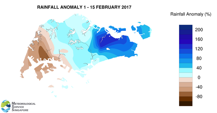
7 While February is typically a drier month of the year, February 2017 had been slightly wetter than usual. Apart from the few periods of consecutive days of dry weather conditions, most days in February 2017 were occasionally windy and cool. The lowest daily minimum temperature recorded in February 2017 was 22.5°C on 15 February 2017 when a monsoon surge[1] was affecting the region between 12 and 15 February 2017. The highest maximum wind gust recorded in February 2017 was 67.4km/h at the Marina South area on 12 February 2017 under the influence of this surge. This is stronger than the highest ever recorded wind gust of 64.4km/h for February at the Changi climate station.
8 In February 2017, the eastern half of Singapore received significantly above normal rainfall. The highest rainfall of 223.2mm (87% above average) was recorded around Pasir Ris area. Rainfall was lowest around Boon Lay area where 99.8mm (32% below average) was recorded.
[1] A monsoon surge refers to a strengthening of winds over the South China Sea, causing extensive rainclouds to form over our surrounding region.

CLIMATE STATION STATISTICS FOR MARCH (Climatological reference period: 1981 – 2010)
| Mean daily maximum temperature | 32.0 °C |
| Mean daily minimum temperature | 24.6 °C |
| Mean monthly temperature | 27.5 °C |
| Mean rainfall for the month | 170.3 mm |
| Mean number of rain days | 13 |
| Highest monthly mean daily maximum temperature | 34.1 °C (1998) |
| Lowest monthlymean daily minimum temperature | 23.7 °C (1982) |
| Highest monthly rainfall | 361.3 mm (1984) |
| Lowest monthly rainfall | 34.3 mm (1997) |