Singapore experiencing Northeast Monsoon conditions. Generally wet weather over the coming fortnight and a few cool nights.
Singapore, 30 November 2017 – Singapore and the surrounding region are currently experiencing the Northeast Monsoon which set in over Singapore in the second half of November 2017. During the Northeast Monsoon season, the prevailing low level winds typically blow predominantly from the northeast.
2 The Northeast Monsoon season typically comprises a wet phase from December to January, followed by a dry phase from February to March. The wet phase is characterised by short-duration moderate to heavy thundery showers, mostly in the afternoon, and on some days extending into the evening. In addition, there can be two to four episodes of monsoon surges[1] which usually bring prolonged, widespread rainfall lasting between two and five days, occasionally windy conditions, and cooler temperatures to Singapore.
3 In the first fortnight of December 2017, wet weather conditions are expected to prevail over Singapore and the surrounding region. During this period, Singapore is expected to experience moderate to heavy short-duration thundery showers in the afternoon and evening on five or six days. Widespread moderate to heavy thundery showers with occasional windy conditions can also be expected between the predawn hours and morning on one or two days.
4 Around the second week of the fortnight, a monsoon surge could develop and affect the South China Sea and the surrounding region. This could bring a few days of cooler temperatures, occasionally windy conditions and widespread moderate to heavy rain to Singapore. Rainfall for the first fortnight of December 2017 is forecast to be well-above normal.
5 During the first half of December 2017, daily maximum temperatures of between 31°C and 32°C are expected. On a few rainy days during the fortnight, the daily maximum and minimum temperatures could drop to around 29°C and 22°C respectively.
6 For updates of the daily weather forecast, please visit the MSS website (https://www.weather.gov.sg), NEA website (www.nea.gov.sg), or download the myENV app, MSS’ Weather@SG app.
REVIEW (1 – 29 November 2017)
7 In the second half of November 2017, the prevailing light and variable winds gradually strengthened to blow from the northeast or northwest as the region transitioned from inter-monsoon conditions to the Northeast Monsoon.
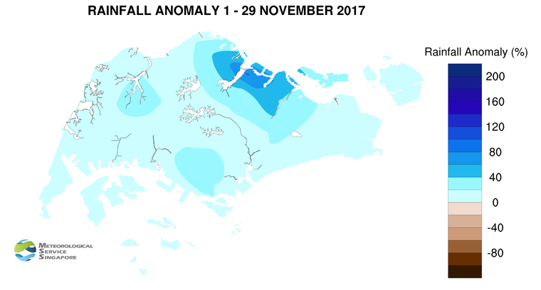
8 In November 2017, the presence of the monsoon rain band over the equatorial belt brought above normal rainfall to most parts of the southern ASEAN region, including Singapore. In the last week of November 2017, a monsoon surge brought widespread moderate to heavy monsoon rains and occasional windy conditions to north-eastern parts of Peninsular Malaysia.
9 During the month, Singapore experienced thundery showers mostly in the afternoon due to strong solar heating of land areas coupled with the convergence of winds over Singapore and the surrounding vicinity. There were several days when the occurrence of Sumatra squalls brought moderate to heavy thundery showers over many parts of Singapore between the predawn hours and morning. The highest daily rainfall recorded for the month was 130.6mm in the East Coast area on 14 November 2017, when the passage of a Sumatra squall brought widespread heavy rain to the island. As at 29 November 2017, the Changi climate station recorded a total of 24 rain days[2] for November 2017, well above the long-term average of 18 rain days for November.
10 On most days during the month, the daily maximum temperatures ranged between 31°C and 33°C. There were however a few warm days with daily maximum temperatures of around 34°C. At the Changi climate station, the monthly mean daily maximum temperature recorded for November 2017 (as of 29 November) was 30.8°C, which is 0.4°C lower than the long-term average daily maximum temperature for November.
11 Most parts of Singapore received well above normal rainfall in November 2017. The highest rainfall of 467.2mm (84% above average) was recorded around the Seletar area. Rainfall was lowest around the Choa Chu Kang area where 250mm (3% above average) was recorded.
[1] A rain day is defined as a day where 0.2mm of more of rain was recorded.
[2] A monsoon surge refers to the strengthening of northeasterly winds blowing from a strong high-pressure system over the northern Asian continent toward the South China Sea, bringing periods of prolonged widespread rain and windy conditions to the surrounding region including Singapore and Peninsular Malaysia. (Further information is available at https://www.weather.gov.sg/learn_weather_systems/).
CLIMATE STATION STATISTICS FOR December (Climatological reference period: 1981 – 2010)
| Mean daily maximum temperature |
30.2 °C |
| Mean daily minimum temperature |
24.0 °C |
| Mean monthly temperature |
26.4 °C |
| Mean rainfall for the month |
318.6 mm |
| Mean number of rain days |
18 |
| Highest monthly mean daily maximum temperature |
31.3 °C (1997, 2002) |
| Lowest monthly mean daily minimum temperature |
23.0 °C (1981, 1983) |
| Highest monthly rainfall |
765.9 mm (2006) |
| Lowest monthly rainfall |
62.9 mm (1989) |