Singapore, 16 July 2025 – The prevailing Southwest Monsoon conditions are forecast to persist over Singapore and the surrounding region with winds blowing mainly from the southeast or southwest.
2 The second half of July 2025 is expected to be drier than the first half of the month. Fair and warm weather can be expected over Singapore on a few days. Localised short-duration thundery showers are forecast in the late morning and afternoon over parts of the island on some days. In addition, widespread thundery showers with gusty winds, due to Sumatra squalls, may occur between the pre-dawn hours and morning on one or two days. The total rainfall for the second half of July 2025 is forecast to be below average over most parts of the island.
3 More warm days are expected in the second half of July 2025, as compared to the first half of the month, with daily maximum temperatures reaching slightly above 34 degrees Celsius on some days. Warm and humid conditions, particularly over the southern and eastern parts of the island are also expected on a few nights, with minimum night-time temperatures hovering around 28 degrees Celsius.
4 For updates of the daily weather forecast, please visit the MSS website (https://www.weather.gov.sg), NEA website (www.nea.gov.sg), or download the myENV app.
REVIEW OF THE PAST TWO WEEKS (1 – 15 JULY 2025)
5 Southwest Monsoon conditions prevailed over Singapore and the surrounding region in the first fortnight of July 2025, with winds blowing mostly from the southeast or southwest.
6 In the first fortnight of July 2025, localised short-duration thundery showers fell over parts of the island on most days. On 9 July 2025, regional convergence of winds brought moderate to heavy thundery showers over many areas of Singapore in the morning. The daily total rainfall of 87.6 mm recorded at Sentosa that day was the highest rainfall recorded for the first fortnight of July 2025.
7 In the first fortnight of July 2025, there were two days where the daily maximum temperature was above 34 degrees Celsius. The highest daily maximum temperature of 34.2 degrees Celsius was recorded at Pulau Ubin on 6 July 2025. There were a few warm nights where the night-time minimum temperature was above 28 degrees Celsius, mainly over the southern and eastern parts of the island.
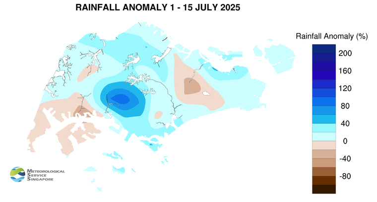
8 Most parts of Singapore recorded above average rainfall in the first fortnight of July 2025. The area around Clementi registered rainfall of 102 per cent above average, and the area around Jurong Pier registered rainfall of 36 per cent below average.
CLIMATE STATION STATISTICS
Long-term Statistics for July
(Climatological reference period: 1991 – 2020)
| Average daily maximum temperature: |
31.4 °C |
| Average daily minimum temperature: |
25.4 °C |
| Average monthly temperature: |
28.2 °C |
| Average rainfall: |
146.6 mm |
| Average number of rain days: |
14 |
Historical Extremes for July
(Rainfall since 1869 and temperature since 1929)
| Highest monthly mean daily maximum temperature: |
32.4 °C (1997) |
| Lowest monthly mean daily minimum temperature: |
22.9 °C (1975) |
|
|
| Highest monthly rainfall ever recorded: |
527.3 mm (1890) |
| Lowest monthly rainfall ever recorded: |
12.2 mm (2019) |