Fortnightly Weather Outlook for 1 – 15 February 2021
Singapore, 1 February 2021 – The first half of February 2021 is expected to be generally dry and warm, with short-duration afternoon thundery showers on some days. The prevailing Northeast Monsoon conditions are forecast to persist in the first half of February 2021, with low-level winds blowing from the northwest or northeast.
2 In the first week of the fortnight, a strengthening of northeast winds over the South China Sea is forecast to bring windy conditions with passing showers over Singapore on a few days. For most part of the week, fair and warm weather can be expected due to stable atmospheric conditions arising from the presence of a dry air mass over the equatorial Southeast Asia region. Short-duration thundery showers are expected in the afternoon mostly in the second half of the fortnight due to strong solar heating of land areas. On a few days, the showers may extend into the evening. Overall, the rainfall for the first half of February 2021 is expected to be below normal over most parts of the island.
3 In the first fortnight of February 2021, the daily temperatures are forecast to range between 24°C and 33°C on most days. The maximum temperature could reach around 34°C on days with little or no rain.
4 For updates of the daily weather forecast, please visit our MSS website (https://www.weather.gov.sg), NEA website (www.nea.gov.sg), or download the MSS’ Weather@SG app, and/or the myENV app.
REVIEW (1 – 31 January 2021)
5 Northeast Monsoon conditions prevailed over Singapore and the surrounding region in January 2021. The prevailing low-level winds blew from the north or northeast.
6 It was exceptionally wet and cool in the first half of January 2021. In comparison, the second half of the month was generally warmer and drier, with short-duration thundery showers over parts of the island in the afternoon on some days.
7 In the first fortnight of January 2021, high-pressure systems over northern continental Asia brought a surge of northeast monsoon winds (monsoon surge[1]) over the equatorial South China Sea region on 1-2 January 2021 and again on 8 – 13 January 2021. Widespread continuous rain, heavy at times fell over Singapore over the New Year weekend and the highest daily total rainfall recorded during the 2-day event was 210.6mm at the Changi climate station.
8 The surge of strong northeast winds coupled with convergence of winds over Singapore and the surrounding region brought windy and rainy weather across the island during the second monsoon surge event (8 – 13 January 2021). Particularly on 10 January 2021, continuous moderate to heavy rain fell over the island, and the total rainfall of 204.0mm recorded at Changi that day was the highest recorded during this surge event.
9 In January 2021, the total rainfall recorded at the Changi climate station was 692.8mm, of which 648.6mm was recorded in the first half of the month. In the second half of the month, only 44.2mm of rain was recorded at the station. January 2021 is thus the second wettest January since rainfall records began in 1869, surpassing the previous record of second wettest January in 1918 where the total rainfall was 634.5mm. The highest ever recorded total rainfall for January is 818.6mm in January 1893.
10 The first half of January 2021 was cooler than the second half of the month, mainly due to the cloudy and rainy weather brought about by the two monsoon surge events. In the first half of the month, the daily maximum temperature was below 30°C on almost all days and the daily minimum temperature was 23°C and below on several days. The lowest daily minimum temperature of 21.1°C was recorded at Newton on 2 January 2021. With the warmer weather in the second half of January 2021, the daily maximum temperature ranged between 31°C and 33°C on most days.
11 At the Changi climate station, the monthly mean temperature of 26.0°C for January 2021 was also the lowest for January in the last 30 years, surpassing the previous January record of 26.1°C in 2018.
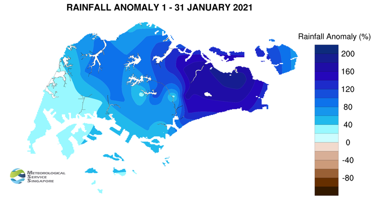
12 The rainfall over Singapore in January 2021 was significantly above normal. The highest anomaly of 194% above average was recorded at Changi. The anomaly was lowest at Jurong at 35% above average.
[1] A monsoon surge refers to a strengthening of winds over the South China Sea, causing extensive rainclouds to form over our surrounding region.
CLIMATE STATION STATISTICS
Long-term Statistics for February
(Climatological reference period: 1981 – 2010)
| Average daily maximum temperature |
31.7 °C |
| Average daily minimum temperature |
24.3 °C |
| Average monthly temperature |
27.1 °C |
| Average rainfall |
112.8 mm |
| Average number of rain days |
8 |
Historical Extremes for February
(Rainfall since 1869 and temperature since 1929)
| Highest monthly mean daily maximum temperature: |
33.5 °C (2010) |
| Lowest monthly mean daily minimum temperature: |
21.6 °C (1930,1934) |
| Highest monthly rainfall ever recorded: |
566.7 mm (1910) |
| Lowest monthly rainfall ever recorded: |
0.2 mm (2014) |