Singapore, 15 October 2021 – In the second fortnight of October 2021, the prevailing Southwest Monsoon conditions, with low-level winds blowing from the southeast or southwest, are forecast to gradually weaken. The shift in wind conditions signals the end of the Southwest Monsoon and the start of the inter-monsoon period.
2 The inter-monsoon period is characterised by light variable winds, warm weather and thunderstorms that can at times be heavy; and is forecast to last through November 2021. Lightning activity tends to be higher during the inter-monsoon months than other months of the year.
3 The second fortnight of October 2021 is expected to be wetter compared to the first fortnight. Thundery showers due to strong day-time heating of land areas, coupled with convergence of winds in the surrounding vicinity, are expected in the late morning and afternoon on most days. On a few of these days, the thundery showers could be heavy, due to large-scale convergence of winds over Singapore and the surrounding region. In addition, widespread thundery showers accompanied with gusty winds, can be expected over Singapore on a few days in the morning, due to Sumatra squalls passing from the Strait of Malacca to the South China Sea. With below-average rainfall registered in the first half of the month and above-average rainfall to be expected for the second fortnight, the overall rainfall for October 2021 is expected to be near-average over most parts of Singapore.
4 The daily temperature on most days in the second fortnight of October 2021 is forecast to range between 24°C and 33°C. Although showers are expected on most days of the fortnight, the daily maximum temperature could still reach a high of around 34°C on a few days. Relatively warm and humid nights with minimum night-time temperatures of up to 28°C can be expected on a few nights, particularly over the eastern and southern coastal areas of the island, when southeast winds bring warm, humid air from the surrounding seas.
5 For updates of the daily weather forecast, please visit our MSS website (https://www.weather.gov.sg), NEA website (www.nea.gov.sg), or download the myENV app.
REVIEW (1 – 14 October 2021)
6 In the first fortnight of October 2021, Southwest Monsoon conditions continued to persist in the region with the low-level winds blowing mostly from the southeast or southwest, and from the west on a few days.
7 The first half of October 2021 was drier and warmer compared to September 2021. Short-duration thundery showers fell over a few parts of Singapore in the late morning and afternoon on most days. On a few days, large-scale convergence of winds over Singapore and the surrounding vicinity brought widespread moderate to heavy thundery showers. The highest daily total rainfall for the first half of October 2021 occurred on 10 October 2021, when 72.4 mm of rain fell around the Changi area in the afternoon.
8 In the past two weeks, there were nine days where maximum temperatures of 34°C or more were recorded. The highest daily maximum temperature of 35.5°C was recorded at Marina Barrage on 12 October 2021 while the lowest daily minimum temperature was 22.3°C recorded at Pasir Panjang on 5 October 2021. There were also a few warm nights, particularly over the southern and south-eastern parts of the island where the night-time minimum temperature was around 28.0°C.
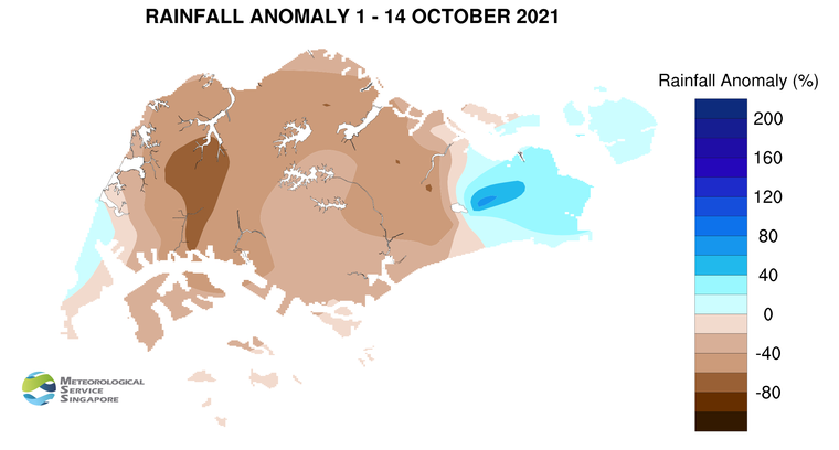
9 Most parts of the island recorded below-average rainfall in the first fortnight of October 2021. About 69% below-average rainfall was recorded at Tengah. The rainfall recorded around Simei was about 74% above-average.
CLIMATE STATION STATISTICS
Long-term Statistics for October
(Climatological reference period: 1991 – 2020)
| Average daily maximum temperature: |
31.8 °C |
| Average daily minimum temperature: |
25.0 °C |
| Average monthly temperature: |
27.9 °C |
| Average rainfall: |
168.3 mm |
| Average number of rain days: |
15 |
Historical Extremes for October
(Rainfall since 1869 and temperature since 1929)
| Highest monthly mean daily maximum temperature: |
33.0 °C (2002) |
| Lowest monthly mean daily minimum temperature: |
22.8 °C (1964) |
| Highest monthly rainfall ever recorded: |
497.1 mm (1942) |
| Lowest monthly rainfall ever recorded: |
10.8 mm (2002) |