Singapore, 31 March 2023 – The Northeast Monsoon conditions prevailing over the region since December 2022 are expected to gradually weaken and end with the onset of inter-monsoon conditions in the first half of April 2023. The prevailing low-level winds over the equatorial Southeast Asia region including Singapore, are forecast to become variable in direction on most days. Brief intensification of high-pressure systems over the Western Pacific Ocean may bring easterly winds to Singapore and the surrounding region on some days.
2 The inter-monsoon period is characterised by warm weather and thunderstorms that can at times be heavy. Lightning activity tends to be higher during the inter-monsoon months than other months of the year. The inter-monsoon period is forecast to persist through May 2023.
3 In the coming fortnight, the monsoon rain band is forecast to lie close to the equatorial Southeast Asia region. Moderate to heavy thundery showers with frequent lightning are expected over parts of the island in the afternoon on most days. On a few of these days, particularly when there is strong convergence of winds in the surrounding vicinity, the thundery showers could extend into the early evening. In addition, Sumatra squalls developing in the Strait of Malacca may bring widespread moderate to heavy thundery showers with occasional gusty winds over Singapore in the pre-dawn hours or mornings on a few days. Less rainfall can be expected in the second week of April 2023, compared to the first week. Overall, the rainfall for the first fortnight of April 2023 is expected to be near average over most parts of the island.
4 While wet weather can be expected in the coming fortnight, the daily maximum temperature could still reach a high of around 35 degrees Celsius on a few days. On most days, the daily temperature is forecast to range between 24 degrees Celsius and 34 degrees Celsius. In addition, the Sumatra squalls may bring cooler daily temperatures of between 23 degrees Celsius and 32 degrees Celsius on a few days.
5 For updates of the daily weather forecast, please visit the MSS website (https://www.weather.gov.sg), NEA website (www.nea.gov.sg), or download the myENV app.
REVIEW (1 – 30 March 2023)
6 Northeast Monsoon conditions prevailed over Singapore and the surrounding region in March 2023. The prevailing low-level winds blew from the northwest or northeast on most days.
7 A high-pressure system over northern continental Asia brought a surge of moderate to strong northeast monsoon winds (monsoon surge[1]) over the equatorial South China Sea region in the first few days of March 2023. The surge that affected Singapore and the surrounding region in end February 2023 continued into 1 March 2023 and brought a daily total rainfall of 104.4mm to the Seng Kang area on that day. On 3-4 March 2023, another monsoon surge brought widespread moderate to heavy rain over Singapore and the surrounding region. After a wet start in the first week of March 2023, there were a few dry and warm days in the second week of March 2023. In the second half of the month, Singapore experienced thundery showers in the afternoon on most days due to strong day-time heating of land areas coupled with convergence of winds either over Singapore or the surrounding vicinity. On 30 March 2023, moderate to heavy thundery showers fell in the late afternoon and evening resulting in a daily total rainfall of 117.4 mm recorded around the Henderson area, and the highest daily total rainfall registered for March 2023.
8 The daily temperature in March 2023 ranged from 21.1 degrees Celsius to 34.9 degrees Celsius. The highest daily maximum temperature of 34.9 degrees Celsius was recorded on 23 March 2023 at Choa Chu Kang. During the monsoon surges in the first week of March 2023, there were three days where the highest daily maximum temperature was below 28 degrees Celsius. On 3 and 4 March 2023, the highest daily maximum temperature only reached 26.1 degrees Celsius at East Coast Parkway. The temperature at Newton dipped to 21.1 degrees Celsius during the monsoon surge on 1 March 2023. That was the lowest daily minimum temperature for March 2023.
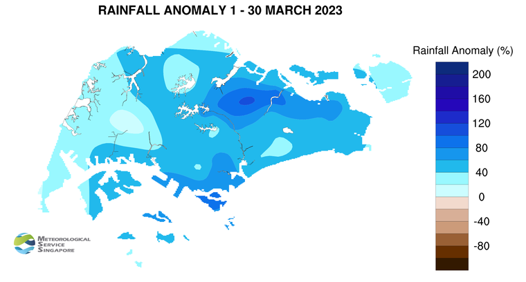
9 Above average rainfall was received across the island in March 2023. The highest anomaly of 110 per cent above average was recorded at Yio Chu Kang. The anomaly was lowest around Jurong West at 5 per cent above average.
[1] A monsoon surge refers to a strengthening of winds over the South China Sea, causing extensive rainclouds to form over our surrounding region. Read more at https://www.weather.gov.sg/learn_weather_systems/
CLIMATE STATION STATISTICS
Long-term Statistics for April
(Climatological reference period: 1991 – 2020)
| Average daily maximum temperature: |
32.4 °C |
| Average daily minimum temperature: |
25.3 °C |
| Average monthly temperature: |
28.2 °C |
| Average rainfall: |
164.3 mm |
| Average number of rain days: |
15 |
Historical Extremes for March
(Rainfall since 1869 and temperature since 1929)
| Highest monthly mean daily maximum temperature: |
33.9 °C (1983) |
| Lowest monthly mean daily minimum temperature: |
23.1 °C (1934) |
|
|
| Highest monthly rainfall ever recorded: |
454.9 mm (1900) |
| Lowest monthly rainfall ever recorded: |
16.6 mm (1977) |