Category Archives: Uncategorized

September 16, 2016

Wet Conditions to Persist in Second Half of September 2016

Cooler nights expected on a few days

Singapore, 16 September 2016 – The prevailing Southwest Monsoon conditions are forecast to persist for the rest of September 2016. During the period, the low level winds are expected to blow mainly from the southwest. With the expected presence of low pressure systems such as tropical storms in our nearby region, the winds could turn to blow from the west on some days.

2       In the second half of September 2016, strong solar heating of land areas could give rise to thundery showers over Singapore on five to seven days, mostly in the late morning and early afternoon. In addition, the development of Sumatra squalls to the west of Singapore is expected to bring widespread thundery showers with occasional gusty winds on two or three days in the pre-dawn hours and morning. Higher rainfall is expected in the second fortnight of this month compared to that in the first fortnight, and the total rainfall for September 2016 is expected to be above normal.

3        For the rest of the month, the daily maximum temperatures on most days are expected to range between 32°C and 33°C. On rainy days, the daily minimum temperature, in particular during the night, would be cooler than normal and range between 22°C and 24°C.

4        For updates of the daily weather and haze forecast, please visit our MSS website (https://www.weather.gov.sg), NEA website (www.nea.gov.sg), the haze microsite (www.haze.gov.sg) or download the myENV app, MSS’ Weather@SG app.

REVIEW: 1 – 15 September 2016

5          In the first half of September 2016, Southwest Monsoon with low level winds blowing mostly from the southeast or southwest prevailed over the region.

6          During the period, Singapore experienced a few warm days in the first few days of the month where the highest daily maximum temperature recorded was 34.2°C. The lowest daily maximum temperature recorded was 29.4°C on 12 September 2016 when rain fell over the island from the early morning and eased off in the later part of the afternoon. The lowest daily minimum temperature recorded ranged between 21.9°C and 25.8°C.

7          On a few days during the review period, squall lines that developed over Sumatra or the Strait of Malacca passed over Singapore, bringing widespread thundery showers and gusty winds in the pre-dawn hours and morning. Arising from the squally weather, rainfall was heaviest on 14 September 2016 over the Paya Lebar-Macpherson area where a total of 86.6mm of rainfall was recorded. Overall, most of the thundery showers in the first half of the month fell in the late morning and early afternoon, and were due to strong solar heating of land areas.

8          In the first fortnight of September 2016, rainfall was slightly above normal over the central and western parts of Singapore. The highest rainfall of 128.9mm (54% above average) was recorded around the Paya Lebar area. Rainfall was lowest around Sentosa island where 39.8mm (53% below average) was recorded. Picture1

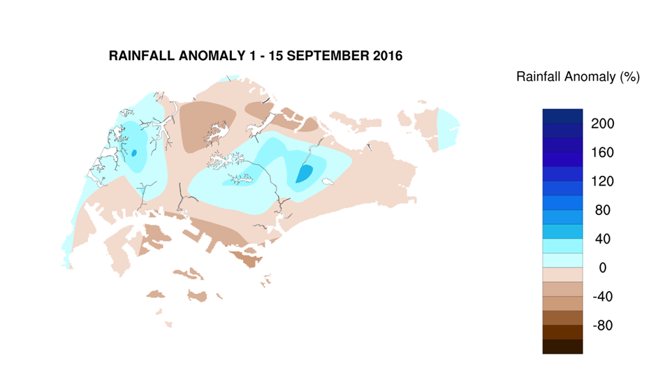
CLIMATE STATION STATISTICS FOR SEPTEMBER (Climatological reference period: 1981 – 2010)

Mean daily maximum temperature 31.4 °C
Mean daily minimum temperature 24.8 °C
Mean monthly temperature 27.6 °C
Mean rainfall for the month 156.5 mm
Mean number of rain days 13
Highest monthly mean daily maximum temperature 32.2 °C (1997)
Lowest monthlymean daily minimum temperature 23.6 °C (1986)
Highest monthly rainfall 440.4 mm (1988)
Lowest monthly rainfall 23.7 mm (1994)


July 15, 2016

Wet Conditions Forecast in Second Half of July 2016

A few warm days can still be expected

Advisory

Singapore, 15 July 2016 –  In the second half of July 2016, the weather in Singapore will continue to be influenced by the prevailing Southwest Monsoon season, and the low level winds are forecast to blow mostly from the south-southeast or southwest.

2 Over the next two weeks, Singapore can expect six to eight days of short-duration thundery showers mostly in the late morning and afternoon. On one or two days between the predawn hours and morning, the passage of a Sumatra squall is expected to bring widespread thundery showers with occasional gusty winds to Singapore. The rainfall for July 2016 is likely to be normal.

3 While more rain days are expected in the second fortnight of July 2016 compared to the first fortnight, the daily maximum temperature could still reach a high of around 34°C on a few days. On most days, it is forecast to range between 32°C and 33°C.

REVIEW (1 – 14 July 2016)

4 Southwest Monsoon conditions prevailed in the first fortnight of July 2016 and the low level winds were blowing predominantly from the south-southeast or southwest.

5 Singapore experienced several warm days during the review period with daily maximum temperatures exceeding 35°C on 5 days. The highest daily maximum temperature of 36°C was recorded in the northern part of Singapore on 3 July 2016. On a few days of the second week of July 2016 when there was widespread rain, the daily minimum temperatures ranged between 22.3°C and 23.2°C. At the Changi climate station, the night time temperatures on most days in the first fortnight of July 2016 were above the long-term climatological July mean minimum temperature of 25°C. The warm nights were due to warm humid air over the sea being blown towards land by southeasterly winds. As at 14 July 2016, the mean temperature recorded at the Changi climate station for July 2016 was 1.4°C warmer than the long-term climatological mean monthly temperature of 27.9°C for July.

6 In the first fortnight July 2016, most of the thundery showers occurred in the morning and were mainly due to strong convergence of winds in the surrounding region as well as passage of a few Sumatra squalls. The rain was heaviest on 13 July 2016 over the Jurong area where the highest total rainfall recorded was 86mm.

7 Many parts of Singapore received below normal rainfall in the first fortnight of July 2016. Rainfall was lowest around Changi where 9.8mm (86% below average) was recorded. Above normal rainfall was recorded in the western parts of the island, with the highest rainfall of 186.6mm (103% above average) recorded around Boon Lay.

FortnightRain_Anomaly_201607a

CLIMATE STATION STATISTICS FOR JULY (Climatological reference period: 1981 – 2010)

Mean daily maximum temperature 31.3 °C
Mean daily minimum temperature 25.0 °C
Mean monthly temperature 27.9 °C
Mean rainfall for the month 154.4 mm
Mean number of rain days 14
Highest monthly mean daily maximum temperature 32.4 °C (1997)
Lowest monthlymean daily minimum temperature 23.8 °C (1981)
Highest monthly rainfall 305.4 mm (1988)
Lowest monthly rainfall 18.6 mm (1997)


March 15, 2016

Expect Very Warm Temperatures in the Next Fortnight

Significant below-normal rainfall forecast for March 2016

Advisory

Singapore, 15 March 2016 – The prevailing Northeast Monsoon conditions are expected to gradually weaken over the next fortnight. The low level winds are forecast to blow predominantly from the northeast or northwest, and become light and variable in direction as the Northeast Monsoon transitions to inter-monsoon conditions in the later part of the month.

2. The next fortnight is expected to be drier and warmer than that experienced in the first fortnight of March 2016. During this period, the daily maximum temperatures are expected to range between 33°C and 34°C, and could reach a high of around 36°C on a few days. The mean monthly temperature for March 2016 is likely to be comparable to that for the warmest March on record (29.5°C in 1998).

3. The warmer conditions are due to the continuing influence of the El Nino and the presence of a dry and warm air mass over the region. The occurrence of the equinox[1] is another contributing factor to the warm temperatures during this time of the year.

4. Despite the drier conditions, short-duration thundery showers in the afternoon on 4 to 6 days can still be expected over parts of Singapore, due to strong solar heating of land areas and convergence of winds in the surrounding vicinity. The rainfall for March 2016 is expected to be significantly below-normal.

Review (1 – 14 March 2016)

5. During the review period, Northeast Monsoon conditions prevailed in the region with the low level winds over Singapore blowing predominantly from the northeast.

6. In the first week of March 2016, Singapore experienced occasionally windy conditions with short-duration thundery showers in the afternoon on some days. Dry and warm conditions were experienced in the second week of the month where the daily maximum temperature recorded was between 34.5°C and 35.0°C.

7. Almost all areas of Singapore received below average rainfall in the first half of March 2016. Rainfall was lowest over the eastern part of the island around Pasir Ris, where 4mm (95% below average) was recorded. The highest rainfall of 119mm (15% above average) was recorded over the southwest-central part of Singapore around Queenstown.

[1] An equinox occurs twice a year around 20 March and 22 September. During an equinox, with the sun directly overhead around noon, sunlight reaching the earth’s surface is most intense and contributes to higher daytime temperatures.

FortnightRain_Anomaly_201603a

CLIMATE STATION STATISTICS FOR MARCH (Climatological reference period: 1981 – 2010)

Mean daily maximum temperature 32.0 degrees Celsius
Mean daily minimum temperature 24.6 degrees Celsius
Mean monthly temperature 27.5 degrees Celsius
Mean rainfall for the month 170.3 mm
Mean number of rain days 13
Highest monthly mean daily maximum temperature 34.1 degrees Celsius (1998)
Lowest monthly mean daily minimum temperature 23.7 degrees Celsius (1982)
Highest monthly rainfall 361.3 mm (1984)
Lowest monthly rainfall 34.3 mm (1997)


February 16, 2016

Start of Dry Phase of Northeast Monsoon in Second Half of February

Short-duration thundery showers on some days

Advisory

Singapore, 16 February 2016 – For the next fortnight, Northeast Monsoon conditions are forecast to persist with the low level winds blowing predominantly from the north or northeast. The prevailing wet phase of the Northeast Monsoon season is expected to gradually transition to the dry phase of the season around the last week of the month. The dry phase of the Northeast Monsoon season is characterised by drier weather and occasionally windy conditions.

2. For the rest of February 2016, localised short-duration thundery showers are expected on 5 to 6 days in the afternoon due to strong solar heating of land areas and convergence of winds in the surrounding vicinity. Rainfall for February 2016 is expected to be near average.

3. It is expected to be drier and warmer in the second half of February 2016 compared to the first two weeks of the month. The temperature for the next fortnight is forecast to range between 25°C and 34°C. The mean monthly temperature for February 2016 is likely to be warmer than the long-term mean of 27.1°C for February. February 2016 could rank among the top five warmest February since records started in 1929.

Review (1 – 15 February 2016)

4. Northeast Monsoon conditions prevailed during the first fortnight of February 2016 with the low level winds over the region blowing predominantly from the northeast. During the Chinese New Year period (7 – 10 February 2016), a monsoon surge brought occasional windy conditions and moderate to heavy rain to areas in the southern South China Sea region.

5. On 7 February 2016, the monsoon surge brought widespread moderate rain to Singapore. The rain occurred from around midnight to the early afternoon, and the highest total daily rainfall recorded was 46.8mm over the northwestern part of the island. For the next three days (8 to 10 February 2016), with a shift in the winds to blow from the north, Singapore experienced cool, cloudy and occasional windy conditions with brief periods of light to moderate rain. Most of the heavy rain as a result of the surge fell over the sea areas to the south of Singapore. Daily maximum temperatures of below 30°C were recorded in Singapore on consecutive days during the Chinese New Year period.

6. For the rest of the review period, Singapore experienced thundery showers mostly in the afternoons and evenings due to strong solar heating of land areas coupled with localised wind convergence. The showers were heaviest on 12 February 2016 where the highest total daily rainfall recorded was 60.2mm around Ang Mo Kio.

7. Most parts of Singapore received above average rainfall in the first half of February 2016. The highest rainfall 125mm (72% above average) was recorded over the northern part of Singapore around Woodlands. Rainfall was lowest over the eastern part of Singapore around Changi, where 41mm (28% below average) was recorded.

8. There were a few warm days during the review period where the highest daily maximum temperature recorded ranged from 33.8°C to 34°C. The lowest daily minimum temperature recorded on a few days was between 21.5°C and 23.5°C. Despite the cooler weather experienced between 7 and 10 February 2016, the mean daily minimum temperature in the first fortnight of February 2016 was 25.9°C which is significantly warmer than the long-term mean of 24.3°C. In addition, the mean daily temperature of 28°C is warmer than the long-term February climatology of 27.1°C.

FortnightRain_Anomaly_201602a

CLIMATE STATION STATISTICS FOR FEBRUARY (Climatological reference period: 1981 – 2010)

Mean daily maximum temperature 31.7 degrees Celsius
Mean daily minimum temperature 24.3 degrees Celsius
Mean monthly temperature 27.1 degrees Celsius
Mean rainfall for the month 112.8 mm
Mean number of rain days 8
Highest monthly mean daily maximum temperature 33.5 degrees Celsius (2010)
Lowest monthly mean daily minimum temperature 23.0 degrees Celsius (1982)
Highest monthly rainfall 470.4 mm (1984)
Lowest monthly rainfall 0.2 mm (2014)