Category Archives: Uncategorized

June 16, 2021

Warm and Humid Weather to Continue for the Rest of June 2021 with Some Showers Expected


Singapore, 16 Jun 2021 – The prevailing Southwest Monsoon conditions over Singapore and the surrounding region are expected to persist for the rest of June 2021. During this period, the monsoon rain band is forecast to lie further north of the Equator, and the low-level winds are expected to blow from the southeast or southwest.

2    The warm and humid conditions in the first half of June 2021 are forecast to continue for the rest of the month. During the second half of June 2021, the daily temperatures are expected to range between 25°C and 34°C on most days and the daily maximum temperature could reach around 35°C on days where there is little or no rain. Warm and humid conditions can also be expected on some nights when prevailing winds from the southeast or south blow warm and humid air from the sea. On these nights, minimum night-time temperatures of up to 28°C can be expected, particularly over the south-eastern parts of the island.

3    On a few days in the early part of the coming fortnight, a mass of dry air from the Indian Ocean is forecast to move over the equatorial Southeast Asia region. The passage of dry air is expected to bring fair and warm weather over Singapore and the surrounding region. On some days during the fortnight, localised short-duration thundery showers are forecast over parts of the island in the late morning and early afternoon due to strong day-time heating of land areas. On one or two days, widespread thundery showers with gusty winds due to Sumatra squalls are forecast between the pre-dawn hours and morning. Overall, the rainfall for June 2021 is expected to be below normal over some parts of Singapore.

4      For updates of the daily weather forecast, please visit our MSS website (https://www.weather.gov.sg), NEA website (www.nea.gov.sg), or download the myENV app.


REVIEW (1 – 15 June 2021)

5    In the first half of June 2021, the light and variable winds over Singapore and the surrounding region strengthened to blow from the southeast or southwest. This shift in the winds in early June 2021 signalled the end of the inter-monsoon period and the start of the Southwest Monsoon season.

6    During the first fortnight of the month, thundery showers fell mostly over the western half of the island in the late morning and afternoon due to strong solar heating of land areas coupled with localised convergence of winds. There were also a few days when thundery showers fell during the night and in the pre-dawn hours. On 15 June 2021, moderate to heavy thundery showers fell mainly over the western and northern parts of the island in the afternoon. The daily total rainfall of 93.8mm recorded at Mandai that day was the highest daily rainfall for the first half of June 2021.

7    The first fortnight of June 2021 was generally warm. There were 9 days where the daily maximum temperature was above 34°C. The highest daily maximum temperature of 35.5°C was recorded at Marina Barrage on 4 June 2021. There were also a few warm nights, particularly over the southern parts of the island where the minimum night-time temperatures ranged between 28.0°C and 29.2°C.

8    In the first half of June 2021, rainfall was below average for most parts of Singapore except in the north-western parts of the island where rainfall was above average. The highest rainfall anomaly of 138% above average was recorded at Choa Chu Kang. The anomaly was lowest at Sentosa at 61% below average.


CLIMATE STATION STATISTICS

Long-term Statistics for June
(Climatological reference period: 1991 – 2020)

Average daily maximum temperature 31.9 °C
Average daily minimum temperature 25.7 °C
Average monthly temperature 28.5 °C
Average rainfall 135.3 mm
Average number of rain days 13


Historical Extremes for June
(Rainfall since 1869 and temperature since 1929)

Highest monthly mean daily maximum temperature: 33.2 °C (1997)
Lowest monthly mean daily minimum temperature: 23.2 °C (1965)
Highest monthly rainfall ever recorded: 378.7 mm (1954)
Lowest monthly rainfall ever recorded: 21.8 mm (2009)


June 1, 2021

Warm and Humid Conditions to Continue with Onset of Southwest Monsoon in First Half of June 2021


Singapore, 1 Jun 2021 – The current warm and humid conditions are forecast to continue into the first fortnight of June 2021. During this period, the prevailing light and variable winds over Singapore and the surrounding region are forecast to strengthen and blow from the southeast or southwest. This signals the end of the inter-monsoon period and the start of the Southwest Monsoon season. The Southwest Monsoon season typically extends into September and is a generally drier season compared to other times of the year.

2      In the first half of June 2021, the monsoon rain band is forecast to lie over the northern Southeast Asia region. This is expected to bring generally dry, warm, and humid conditions over Singapore and the surrounding region on some days. Localised short-duration showers at times with thunder can be expected over a few parts of the island in the late morning and early afternoon on some days. In addition, on one or two days, Sumatra squalls moving from the Strait of Malacca to the South China Sea are expected to bring island-wide thundery showers with occasional gusty winds in the morning. The overall rainfall for the first half of June 2021 is likely to be below normal over most parts of Singapore.

3      During the fortnight, the nights are also expected to be warm and humid. Warm nights typically occur when the prevailing winds blow from the southeast and brings warm, humid air from the sea over the land. Night-time minimum temperatures of up to 28°C can be expected on some days. The daily temperature on most days is forecast to range between 25°C and 34°C. The daily maximum temperature could reach around 35°C on a few days, particularly when there are few clouds in the sky.

4      For updates of the daily weather forecast, please visit our MSS website (https://www.weather.gov.sg), NEA website (www.nea.gov.sg), or download the myENV app.


REVIEW (1 – 31 May 2021)

5      Inter-monsoon conditions prevailed over Singapore and the surrounding region in May 2021. During the month, the low-level prevailing winds were generally light and blew from the east, southeast or southwest.

6      In May 2021, thundery showers fell over parts of the island on most days, mainly in the late morning and afternoon. The showers were due to strong daytime heating of land areas and/or convergence of winds over Singapore and the surrounding vicinity. The heaviest thundery showers during the month occurred on 17 and 18 May 2021, particularly over the western and central parts of the island. On both days, convergence of winds over Singapore and the surrounding vicinity brought thundery showers in the late morning and early afternoon and again in the night. The highest rainfall recorded on 17 May 2021 was 117.2mm at Jurong West. On 18 May 2021, the daily total rainfall recorded at Toa Payoh was 132.0mm, which is the highest daily total for May 2021.

7      Climatologically, May is one of the warmest months of the year. In May 2021, the highest daily maximum temperature recorded across the island was at least 34°C on 18 days. The highest daily maximum temperature of 35.7°C was recorded at Marina Barrage on 11 May 2021. There were also a few warm nights where the night-time temperature was around 28°C particularly over the south-eastern part of the island.

8      Rainfall was slightly above average for most parts of Singapore in May 2021. The highest rainfall anomaly of 69% above average was recorded at Jurong. The anomaly was lowest at Kranji at 56% below average.


CLIMATE STATION STATISTICS

Long-term Statistics for June
(Climatological reference period: 1991 – 2020)

Average daily maximum temperature 31.9 °C
Average daily minimum temperature 25.7 °C
Average monthly temperature 28.5 °C
Average rainfall 135.3 mm
Average number of rain days 13


Historical Extremes for June
(Rainfall since 1869 and temperature since 1929)

Highest monthly mean daily maximum temperature: 33.2 °C (1997)
Lowest monthly mean daily minimum temperature: 23.2 °C (1965)
Highest monthly rainfall ever recorded: 378.7 mm (1954)
Lowest monthly rainfall ever recorded: 21.8 mm (2009)


May 17, 2021

More Warm Days for Rest of May 2021 with Drier Weather Expected Around Month’s End


Singapore, 17 May 2021 – The prevailing inter-monsoon conditions over Singapore and the surrounding region are expected to persist for the rest of May 2021. During this period, the light and variable low-level winds are forecast to gradually strengthen to blow from the southeast or southwest in the latter half of the fortnight.

2      In the second fortnight of May 2021, short-duration thundery showers are expected over parts of the island in the late morning and early afternoon on some days due to strong daytime heating of land areas. On a few days, convergence of low-level winds over the Strait of Malacca may trigger the development of Sumatra squalls. The eastward passage of the squall toward the South China Sea is expected to bring widespread thundery showers and gusty winds over Singapore between the predawn hours and morning.

3      In the latter half of the fortnight, the monsoon rain band is forecast to shift further north of the Equator, away from Singapore. This is expected to bring less rainfall over the equatorial Southeast Asia region, including Singapore. In addition, with a low pressure system forecast to develop over the northern South China Sea, this could bring drier and warmer conditions over Singapore and the surrounding region. Overall, the rainfall for May 2021 is expected to be below average over some parts of the island.

4      For the rest of May 2021, it is expected to be warm and the daily temperature is forecast to range between 24°C and 34°C on most days. With drier weather in the latter half of the fortnight, warmer conditions can be expected with daytime temperatures around 35°C on some days. The weather during the night can be warm when prevailing winds blow from the southeast or south, bringing warm and humid air from the sea over the land. Night-time temperatures of around 28°C are expected on some nights.

5      For updates of the daily weather forecast, please visit our MSS website (https://www.weather.gov.sg), NEA website (www.nea.gov.sg), or download the myENV app.


REVIEW (1 – 16 May 2021)

6      Inter-monsoon conditions prevailed over Singapore and the surrounding region in the first half of May 2021, and the prevailing winds were generally light and blew from the east or southeast. On some days, the prevailing winds shifted to blow from the southwest.

7      In the first fortnight of May 2021, there were thundery showers mainly in the late morning and afternoon over many parts of the island due to strong daytime heating of land areas. On a few of these days, the thundery showers were intense due to convergence of winds in the surrounding region. There were thundery showers over some parts of the island on a few nights.

8      On 5 May 2021, moderate to heavy thundery showers fell over the northern and central parts of Singapore in the afternoon. The daily total rainfall of 113.6mm recorded at Upper Peirce Reservoir that day was the highest daily total for the first half of May 2021.

9      The warm weather in April 2021 continued into the first half of May 2021. There were 9 days where maximum temperatures of 34°C or more were recorded. The highest daily maximum temperature of 35.7°C was recorded at Marina Barrage on 11 May 2021.

10     Rainfall was near-average for most parts of Singapore in the first half of May 2021. The highest anomaly of 73% above average was recorded at Jurong West. The lowest anomaly of 58% below average was at Kranji.


CLIMATE STATION STATISTICS

Long-term Statistics for May
(Climatological reference period: 1981 – 2010)

Average daily maximum temperature 32.2 °C
Average daily minimum temperature 25.4 °C
Average monthly temperature 28.3 °C
Average rainfall 171.2 mm
Average number of rain days 14


Historical Extremes for May
(Rainfall since 1869 and temperature since 1929)

Highest monthly mean daily maximum temperature: 33.6 °C (1997)
Lowest monthly mean daily minimum temperature: 23.5 °C (1974)
Highest monthly rainfall ever recorded: 386.6 mm (1892)
Lowest monthly rainfall ever recorded: 41.6 mm (1997)


April 16, 2021

Wet Weather to Continue in Second Half of April 2021

Fortnightly Weather Outlook for 16 – 30 April 2021


Singapore, 16 April 2021 – The prevailing inter-monsoon conditions over Singapore and the surrounding region are expected to persist through May 2021. In the coming fortnight, more showers are forecast over Singapore and the surrounding vicinity, and the low-level winds are forecast to blow from the southwest or west. In the later part of the fortnight, the winds are expected to weaken to become light and variable in direction.

2      In the early part of the coming fortnight, a low-pressure system is forecast to develop over the western Pacific Ocean. This is expected to bring large scale convergence of winds blowing from the west and southwest over the equatorial Southeast Asia region. On most days during this period, Sumatra squalls are forecast to develop over the Strait of Malacca and move eastwards to bring widespread thundery showers and gusty winds over Singapore between the predawn hours and morning.

3      In the later part of the fortnight, the winds are forecast to become light and variable in direction. On most days during this period, short-duration moderate to heavy thundery showers with frequent lightning are expected in the afternoon over parts of the island. Overall, the rainfall in April 2021 is forecast to be above average over most parts of the island.

4      During the fortnight, the daily maximum temperatures on most days are expected to range between 33°C and 34°C. On a few rainy days, the daily minimum temperature could reach a low of around 22°C.

5      For updates of the daily weather forecast, please visit our MSS website (https://www.weather.gov.sg), NEA website (www.nea.gov.sg), or download the myENV app, or the MSS’ Weather@SG app.


REVIEW (1 – 15 April 2021)

6      Northeast Monsoon conditions transitioned to inter-monsoon conditions in early April 2021. The low-level winds blew from the northeast or northwest before becoming light and variable in direction around the end of the first week of the month.

7      In the first two weeks of April 2021, thundery showers fell over parts of the island in the afternoon on most days due to strong solar heating of land areas. On a few days, the showers continued into the evening due to large-scale convergence of winds in the surrounding region. The highest daily total rainfall recorded in the first fortnight of April 2021 was 96.0mm at Jurong on 3 April 2021.

8      Although it rained on most days during the first half of the month, there were 12 days during the period when the daily maximum temperature was more than 34°C. The highest daily maximum temperature during the first fortnight of April 2021 was 36.3°C recorded at Ang Mo Kio on 2 April 2021.

9      Many parts of Singapore recorded above-average rainfall in the first fortnight of April 2021. The rainfall recorded at Changi was 104% above-average while that recorded at Kranji was 23% below-average.


CLIMATE STATION STATISTICS

Long-term Statistics for April
(Climatological reference period: 1981 – 2010)

Average daily maximum temperature 32.3 °C
Average daily minimum temperature 25.0 °C
Average monthly temperature 28.0 °C
Average rainfall 154.8 mm
Average number of rain days 14


Historical Extremes for April
(Rainfall since 1869 and temperature since 1929)

Highest monthly mean daily maximum temperature: 33.9 °C (1983)
Lowest monthly mean daily minimum temperature: 23.1 °C (1934)
Highest monthly rainfall ever recorded: 454.9 mm (1900)
Lowest monthly rainfall ever recorded: 16.6 mm (1977)


February 14, 2020

Expect Windy Conditions on Most Days for Rest of February 2020
For most days in the rest of Feb 2020, windy conditions are expected. Most of the showers are likely in the latter half of the fortnight.  Daily max temperature could reach around 34°C on a few days.

Fortnightly Weather Outlook for 14 – 29 February 2020


Singapore, 14 February 2020 – For the second half of February 2020, the Meteorological Service Singapore (MSS) forecasts windy conditions on most days. Afternoon thundery showers are also expected, mostly later in the fortnight. The prevailing Northeast Monsoon season in the region is forecast to continue, with low-level winds blowing from the north or northeast.

2          In the early part of the fortnight, an intensification of a high-pressure system over north Asia is forecast to bring a strengthening of winds over the South China Sea region including Singapore. Windy conditions with few passing showers are expected on most days over Singapore. On one or two days during the period, widespread thundery showers are forecast due to the convergence of winds in the surrounding vicinity. In the latter part of the fortnight, with the monsoon rain band forecast to lie close to the equatorial Southeast Asia region, enhanced thunderstorm cloud development can be expected over Singapore. This is forecast to bring short-duration moderate to heavy thundery showers in the afternoon over parts of Singapore on some days. Overall, the rainfall for February 2020 is forecast to be near normal over most parts of the island.

3          The daily temperatures in the second fortnight of February 2020 are forecast to range between 24°C and 33°C on most days. Warm conditions can be expected on a few days with a maximum temperature of around 34°C.

4         For updates of the daily weather and haze situation, please visit the MSS website (https://www.weather.gov.sg), NEA website (www.nea.gov.sg), or download the myENV app, MSS’ Weather@SG app, and the haze microsite (www.haze.gov.sg).


REVIEW (1 – 13 February 2020)

5          Northeast Monsoon conditions prevailed over Singapore and the surrounding region in the first fortnight of February 2020. The low-level winds during the fortnight blew mostly from the north or northeast.

6          In the first half of February 2020, the monsoon rain band was located south of the Equator, and winds over the South China Sea region were generally strong. These brought windy conditions on most days over Singapore during the fortnight, and in the first week of the month, little or no rain fell over the island. In the second week of February 2020, thundery showers fell over Singapore in the afternoon on most days due to strong solar heating of land areas coupled with convergence of winds in the surrounding vicinity. On 10 February 2020, thundery showers fell over many areas of the island between the late afternoon and evening. The daily total rainfall of 108.8 mm recorded at Tuas that day was the highest daily total rainfall recorded for the first fortnight of February 2020.

7          In the first half of February 2020, the daily maximum temperature ranged between 31.0°C and 34.4°C, and the daily minimum temperature was between 22.8°C and 25.2°C. The highest daily maximum temperature of 34.4°C was recorded on 5 February 2020 at Choa Chu Kang. The lowest daily maximum temperature of 31.0°C was recorded on 11 February 2020 when widespread thundery showers fell over the island from the late morning that day before clearing in the early hours of the following day.

8          About half of the island recorded near-normal rainfall in the first half of February 2020. The rainfall recorded at Choa Chu Kang was 54% below average while that recorded at Ang Mo Kio was 69% above average.


CLIMATE STATION STATISTICS

Long-term Statistics for February
(Climatological reference period: 1981 – 2010)

Average daily maximum temperature 31.7 °C
Average daily minimum temperature 24.3 °C
Average monthly temperature 27.1 °C
Average rainfall 112.8 mm
Average number of rain days 8


Historical Extremes for February
(Rainfall since 1869 and temperature since 1929)

Highest monthly mean daily maximum temperature: 33.5 °C (2010)
Lowest monthly mean daily minimum temperature: 21.6 °C (1930, 1934)
Highest monthly rainfall ever recorded: 566.7 mm (1910)
Lowest monthly rainfall ever recorded: 0.2 mm (2014)


January 16, 2020

More Showers Expected in Second Half of January 2020
2nd fortnight of Jan 2020 to be wetter than 1st fortnight.  Expect mostly short-duration thundery showers in the afternoon (8 – 10 days). Daily temperature on most days between 24°C and 33°C, with high of around 34°C on a few days.

Fortnightly Weather Outlook for 16 – 31 January 2020


Singapore, 16 January 2020 – For the rest of January 2020, the Meteorological Service Singapore (MSS) forecasts more showers during the prevailing Northeast Monsoon season and low-level winds to continue blowing from the north or northeast.

2          With the migration of the monsoon rain band closer to the equatorial Southeast Asia region, the second fortnight of January 2020 can expect more showers compared to the first fortnight of the month. During this period, convergence of winds coupled with strong daytime heating of land areas is expected to bring thundery showers mostly in the afternoon on eight to ten days. Overall, rainfall in January 2020 is forecast to be below normal over most parts of Singapore.

3          The daily temperature forecast for most days in the second fortnight of 2020 is between 24°C and 33°C. During the fortnight, it can be warm on a few days with daily maximum temperatures of around 34oC. Daily minimum temperatures could reach a low of around 23°C on a few nights.

4         For updates of the daily weather and haze situation, please visit the MSS website (https://www.weather.gov.sg), NEA website (www.nea.gov.sg), or download the myENV app, MSS’ Weather@SG app, and the haze microsite (www.haze.gov.sg).


REVIEW (1 – 15 January 2020)

5         Northeast Monsoon conditions prevailed over Singapore and the surrounding region in the first half of January 2020. On most days during this period, the low-level winds were blowing from the northeast.

6          Singapore and the surrounding region experienced windy conditions in the first two weeks of 2020. In the first half of the fortnight, strong prevailing northeasterly winds coupled with convergence of winds in the surrounding region brought brief periods of light to moderate showers to Singapore on a few days. In the second half of the fortnight, a weakening of the prevailing winds and strong daytime heating of land areas brought short-duration thundery showers in the afternoon on some days. The highest daily total rainfall recorded in the first fortnight of 2020 was 43.2 mm on 12 January 2020 at Tanjong Katong. The thundery showers that day fell over most parts of the island between the late afternoon and evening.

7          During the fortnight, the daily maximum temperature across the island ranged between 31.6°C and 33.5°C, with the highest temperature of 33.5°C recorded on 12 January 2020 at Paya Lebar. The daily minimum temperature ranged between 22.8°C and 24.7°C. 12 January 2020 also recorded the lowest daily minimum temperature of 22.8°C at Pasir Panjang, which was associated with thundery showers over most parts of the island that day.

8          Singapore received well below normal rainfall in the first fortnight of January 2020. The highest anomaly of 86% below average was recorded at Sentosa. The anomaly was lowest at Tanjong Katong at 35% below average.

.


CLIMATE STATION STATISTICS

Long-term Statistics for January
(Climatological reference period: 1981 – 2010)

Average daily maximum temperature 30.4 °C
Average daily minimum temperature 23.9 °C
Average monthly temperature 26.5 °C
Average rainfall 234.6 mm
Average number of rain days 13


Historical Extremes for January
(Rainfall since 1869 and temperature since 1929)

Highest monthly mean daily maximum temperature: 31.8 °C (1998, 2016)
Lowest monthly mean daily minimum temperature: 21.6 °C (1934)
Highest monthly rainfall ever recorded: 818.6 mm (1893)
Lowest monthly rainfall ever recorded: 15.4 mm (1997)


November 1, 2019

Wet Weather To Continue in First Half of November 2019
Wet weather with light and variable winds to continue in 1st half of Nov 2019. Moderate to heavy thundery showers in afternoon (6-8 days); widespread thundery showers between predawn and early morning (1-2 days). Daily temperature on most days between 24°C and 34°C, with high of around 35°C on a few days.

Fortnightly Weather Outlook for 1 – 15 November 2019


Singapore, 1 November 2019 – The inter-monsoon conditions that have been prevailing over Singapore since early October 2019 are expected to persist into November 2019. In the first half of November 2019, the low-level winds are forecast to be light and variable in direction, and may temporarily blow from the southwest or west on a few days.

2          In the first fortnight of the month, Singapore can expect moderate to heavy thundery showers due to light winds coupled with strong daytime heating of land areas in the afternoon on six to eight days. On one or two of these days, the showers could start in the late morning. In the early part of the fortnight, low-pressure systems developing over the Western Pacific Ocean and the northern South China Sea is forecast to bring a temporary shift in the winds to blow from the southwest or west over Singapore and the surrounding vicinity. This could result in the passage of Sumatra squalls over Singapore, bringing widespread thundery showers with occasional gusty winds between the predawn and early morning on one or two days. Overall, the rainfall for Singapore in the first fortnight of November 2019 is likely to be near normal.

3          In the first fortnight of November 2019, the daily temperature on most days is forecast to range between 24°C and 34°C. On a few days, the daily maximum temperature could reach a high of around 35°C.

4          On a few mornings during the fortnight, the accumulation of particulate matter in the atmosphere under light wind conditions could bring some slight haziness over Singapore. Such slight haziness in the atmosphere usually improves in the latter part of the morning as the winds strengthen, which helps to disperse the pollutants.

5         For updates of the daily weather and haze situation, please visit the MSS website (https://www.weather.gov.sg), NEA website (www.nea.gov.sg), or download the myENV app, MSS’ Weather@SG app, and the haze microsite (www.haze.gov.sg).


REVIEW (1 – 31 October 2019)

6          In October 2019, Singapore and the surrounding region experienced inter-monsoon conditions with winds that were generally light and variable in direction. The monsoon rain band remained close to the equatorial Southeast Asia region, and brought thundery showers over Singapore on most days of the month.

7          During the month, moderate to heavy thundery showers affected Singapore mostly in the afternoon. The showers were due to localised development of thunderstorm clouds under the influence of light winds and strong daytime heating of land areas. On some of these days, there was also strong convergence of winds in the surrounding vicinity and the thundery showers extended into the evening. Overall, the second half of October 2019 was wetter than the first half of the month. On 27 October 2019, following a heavy downpour over many parts of the island in late afternoon and evening, the climate station in Changi recorded a daily total rainfall recorded was 99.2 mm. This is the second record highest daily total rainfall for October at a climate station since rainfall records began 1869. The highest ever-recorded climate station daily total rainfall for October is 139.8 mm in 2013.

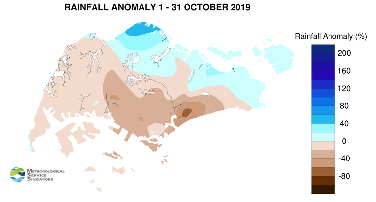
8          Thundery showers fell over the island on most days in October 2019. The average monthly total rainfall of 175.5mm[1] surpassed the “40%-below-normal” October mark of 120.4mm. This ended the rainfall deficit[2] that Singapore had been experiencing since July 2019.

9              There were several warm days in October 2019 despite the wet weather. The daily maximum temperature on several days climbed to above 34°C, and the highest daily maximum temperature recorded was 35.7°C on 13 October 2019 at Clementi.  At the climate station in Changi, the average maximum temperature for October 2019 was 32.7°C. This is the second highest average maximum temperature for October following the record high of 33.0°C set in October 2002.

10        In October 2019, rainfall was above average over the northern and eastern parts of the island, while for the rest of the island, rainfall was below average. Admiralty recorded the highest rainfall anomaly of 58% above average, while Tanjong Katong, in the southeastern part of Singapore, recorded the highest rainfall anomaly of 73% below average.

[1] Recorded at rainfall stations across the island with long-term records

[2] A rainfall deficit situation refers to a period of at least three consecutive months with monthly rainfall more than 40% below the climatological rainfall, averaged over the rainfall stations with long term records across the island. 

CLIMATE STATION STATISTICS

Long-term Statistics for November
(Climatological reference period: 1981 – 2010)

Average daily maximum temperature 31.1 °C
Average daily minimum temperature 24.3 °C
Average monthly temperature 27.0 °C
Average rainfall 258.5 mm
Average number of rain days 18


Historical Extremes for November
(Rainfall since 1869 and temperature since 1929)

Highest monthly mean daily maximum temperature: 32.1 °C (2015)
Lowest monthly mean daily minimum temperature: 22.4 °C (1933)
Highest monthly rainfall ever recorded: 521.5 mm (1874)
Lowest monthly rainfall ever recorded: 53.5 mm (1981)


August 1, 2019

Dry and Warm Conditions to Persist into August 2019 Following Record Dry July 2019
Jul’19-driest July on record. Dry and warm conditions to persist into Aug with an occasional breeze on some days. Short-duration thundery showers on 4-5 days (late morning & early afternoon), Sumatra squalls on 1-2 mornings. Temp 26°C to 33°C, with a high exceeding 34°C on some days. 

Fortnightly Weather Outlook for 1 – 15 August 2019


Singapore, 1 August 2019 – The prevailing Southwest Monsoon conditions in the region are forecast to persist in the first fortnight of August 2019 and last till October 2019.  During the period, the low level winds are expected to blow from the southeast or south.

2          During the fortnight, the monsoon rain band is forecast to maintain its position over the northern Southeast Asia region. Furthermore, with the occasional intrusion of dry air from high pressure systems in the southern hemisphere, the weather during the fortnight is forecast to be drier than that in the second half of July 2019. The prevailing winds extending from these high pressure systems are expected to strengthen around the equatorial region. This can bring occasional breezy conditions on some days to Singapore and the surrounding vicinity.

3          Despite the drier conditions in the coming fortnight, localised short-duration thundery showers can still be expected on four or five days in the late morning and early afternoon. In addition, Sumatra squalls are forecast to bring thundery showers and gusty winds in the morning on one or two days. The rainfall in the coming fortnight is likely to be well-below normal.

4          The first fortnight of August 2019 is expected to be as warm as the last fortnight of July 2019. The daily temperature over Singapore is forecast to range between 26°C and 33°C, and could exceed 34°C on some days. In addition, on some nights, warm and humid conditions with night-time minimum temperatures of around 28°C can be expected when prevailing winds blowing from the southeast bring in warm air from the surrounding seas.

5          The surrounding region is also expected to experience dry weather in the coming weeks.  Hotspots with smoke plumes have been observed in central Sumatra and southern Kalimantan in recent days. Depending on the direction of the prevailing winds and location of the fires, Singapore may experience occasional haze in the first fortnight of August 2019.

6         For updates of the daily weather forecast, please visit our MSS website (https://www.weather.gov.sg), NEA website (www.nea.gov.sg), or download the myENV app, or the MSS’ Weather@SG app.


REVIEW (1 – 31 July 2019)

7          In July 2019, Southwest Monsoon conditions continued to persist with the low level winds blowing from the southeast or southwest.

8          In the first half of July 2019, short-duration thundery showers fell in the late morning and afternoon on most days due to strong solar heating of land areas and convergence of winds in the surrounding vicinity. The highest daily total rainfall for July 2019 was 51.6mm recorded at Mandai on 8 July 2019. The second half of July 2019 was mostly dry and warm over Singapore and the surrounding region, partly due to a mass of dry air blowing from the southern hemisphere toward the equatorial region. At the Changi climate station, the total rainfall recorded for July 2019 was 12.2mm. This makes July 2019 the driest July in Singapore since rainfall records began in 1869. The previous record was 18.6mm set in July 1997.

9          July 2019 was also a warm month. The daily maximum temperature in July 2019 ranged between 28.7°C and 34.5°C. There were also a few warm nights where the night-time temperature was around 28°C mostly over the southern and eastern parts of the island. At the climate station in Changi, the monthly average temperature for July 2019 was 29.0°C. This ranks July 2019 as the second warmest July on record since temperature records began in 1929, after July 2015 with an average temperature of 29.1°C. The average minimum temperature for July 2019 was 26.9°C, surpassing the July record high temperature of 26.7°C in 2015.

10          Well-below-average rainfall was recorded across the island in July 2019. The lowest anomaly of 92% below-average was recorded at Changi.

CLIMATE STATION STATISTICS

Long-term Statistics for August
(Climatological reference period: 1981 – 2010)

Average daily maximum temperature 31.4 °C
Average daily minimum temperature 25.0 °C
Average monthly temperature 27.9 °C
Average rainfall 148.9 mm
Average number of rain days 14


Historical Extremes for August
(Rainfall since 1869 and temperature since 1929)

Highest monthly mean daily maximum temperature: 32.6 °C (1997)
Lowest monthly mean daily minimum temperature: 23.0 °C (1962)
Highest monthly rainfall ever recorded: 526.8 mm (1878)
Lowest monthly rainfall ever recorded: 18.0 mm (1888)

July 1, 2019

Aeronautical Meteorology Course for the National Meteorological and Hydrological Services of the South-West Pacific Island States and Territories in Regional Association V, Singapore, 27-31 May 2019

The Meteorological Service Singapore (MSS), in collaboration with the WMO, conducted the first run of the Training Course on Aeronautical Meteorology for National Meteorological and Hydrological Services (NMHSs) of the Southwest Pacific Island States and Territories in Singapore on 27 – 31 May 2019.  The training course was conducted in support of the WMO long-term goal of closing the capacity gap on essential service delivery in developing countries.  Aviation weather services is the third highest priority area for Regional Association (RA) V based on a regional survey conducted in 2018.

The training course was attended by 13 meteorological professionals from 11 countries across the Southwest Pacific.  Over the course of five days, trainers from the MSS and Bureau of Meteorology (BOM), Australia shared on the generation of operational meteorological data, meteorological sensors in support of aviation operations and the implementation of WMO competency framework and quality management system. They were also updated on the developments in international aeronautical meteorology.  To apprise them on WMO’s role and function in aeronautical meteorology, a special session was arranged with the WMO Aeronautical Meteorology Division via web conference.

Participants also visited the Meteorological Station at the Seletar Airport and Central Forecast Office where they learnt about the operations of MSS, and its supporting infrastructure and specialised systems.

In her opening remarks, Ms Wong Chin Ling, Director-General of MSS, highlighted the evolving role of the aeronautical meteorological service provider in the face of the transformation of global air navigation system. Noting the importance of continuing education and training for aeronautical meteorological personnel, Ms Wong reaffirmed MSS’ commitment to support WMO’s capability development programmes for the Region. The training course will be conducted on regular basis, and future runs will take into account participants’ priority needs and global emerging trends.

June 27, 2019

What’s On

Aeronautical Meteorology Course for the National Meteorological and Hydrological Services of the South-West Pacific Island States and Territories in Regional Association V, 27 – 31 May 2019

The Meteorological Service Singapore (MSS), in collaboration with the WMO, conducted the first run of the Training Course on Aeronautical Meteorology for National Meteorological and Hydrological Services (NMHSs) of the Southwest Pacific Island States and Territories in Singapore on 27 – 31 May 2019.  The training course was conducted in support of the WMO long-term goal of closing the capacity gap on essential service delivery in developing countries……

11th Global Climate Observing System (GCOS) Reference Upper Air network (GRUAN) Implementation and Co-ordination Meeting (ICM-11), 20-24 May 2019

The ICM-11 is a key event in the GRUAN calendar as it provides an opportunity to bring together contributing GRUAN site managers and scientists to discuss operational and organizational issues. This year, MSS not only hosted the annual meeting but it’s Upper Air Observator was certified as a Global Climate Observing System (GCOS) Reference Upper Air Network in May 2019. This is a significant milestone for MSS, as it joins the league of 11 other stations globally……