Category Archives: Uncategorized

March 31, 2023

More Warm Days Expected in First Half of April 2023 with Onset of Inter-Monsoon Conditions

Singapore, 31 March 2023 – The Northeast Monsoon conditions prevailing over the region since December 2022 are expected to gradually weaken and end with the onset of inter-monsoon conditions in the first half of April 2023. The prevailing low-level winds over the equatorial Southeast Asia region including Singapore, are forecast to become variable in direction on most days. Brief intensification of high-pressure systems over the Western Pacific Ocean may bring easterly winds to Singapore and the surrounding region on some days.

2      The inter-monsoon period is characterised by warm weather and thunderstorms that can at times be heavy.  Lightning activity tends to be higher during the inter-monsoon months than other months of the year. The inter-monsoon period is forecast to persist through May 2023.

3      In the coming fortnight, the monsoon rain band is forecast to lie close to the equatorial Southeast Asia region. Moderate to heavy thundery showers with frequent lightning are expected over parts of the island in the afternoon on most days. On a few of these days, particularly when there is strong convergence of winds in the surrounding vicinity, the thundery showers could extend into the early evening. In addition, Sumatra squalls developing in the Strait of Malacca may bring widespread moderate to heavy thundery showers with occasional gusty winds over Singapore in the pre-dawn hours or mornings on a few days. Less rainfall can be expected in the second week of April 2023, compared to the first week. Overall, the rainfall for the first fortnight of April 2023 is expected to be near average over most parts of the island.

4      While wet weather can be expected in the coming fortnight, the daily maximum temperature could still reach a high of around 35 degrees Celsius on a few days. On most days, the daily temperature is forecast to range between 24 degrees Celsius and 34 degrees Celsius. In addition, the Sumatra squalls may bring cooler daily temperatures of between 23 degrees Celsius and 32 degrees Celsius on a few days.

5       For updates of the daily weather forecast, please visit the MSS website (https://www.weather.gov.sg), NEA website (www.nea.gov.sg), or download the myENV app.


REVIEW (1 – 30 March 2023)

6      Northeast Monsoon conditions prevailed over Singapore and the surrounding region in March 2023. The prevailing low-level winds blew from the northwest or northeast on most days.

7      A high-pressure system over northern continental Asia brought a surge of moderate to strong northeast monsoon winds (monsoon surge[1]) over the equatorial South China Sea region in the first few days of March 2023. The surge that affected Singapore and the surrounding region in end February 2023 continued into 1 March 2023 and brought a daily total rainfall of 104.4mm to the Seng Kang area on that day. On 3-4 March 2023, another monsoon surge brought widespread moderate to heavy rain over Singapore and the surrounding region. After a wet start in the first week of March 2023, there were a few dry and warm days in the second week of March 2023. In the second half of the month, Singapore experienced thundery showers in the afternoon on most days due to strong day-time heating of land areas coupled with convergence of winds either over Singapore or the surrounding vicinity. On 30 March 2023, moderate to heavy thundery showers fell in the late afternoon and evening resulting in a daily total rainfall of 117.4 mm recorded around the Henderson area, and the highest daily total rainfall registered for March 2023.

8      The daily temperature in March 2023 ranged from 21.1 degrees Celsius to 34.9 degrees Celsius. The highest daily maximum temperature of 34.9 degrees Celsius was recorded on 23 March 2023 at Choa Chu Kang.  During the monsoon surges in the first week of March 2023, there were three days where the highest daily maximum temperature was below 28 degrees Celsius. On 3 and 4 March 2023, the highest daily maximum temperature only reached 26.1 degrees Celsius at East Coast Parkway. The temperature at Newton dipped to 21.1 degrees Celsius during the monsoon surge on 1 March 2023. That was the lowest daily minimum temperature for March 2023.

9       Above average rainfall was received across the island in March 2023. The highest anomaly of 110 per cent above average was recorded at Yio Chu Kang. The anomaly was lowest around Jurong West at 5 per cent above average.


[1] A monsoon surge refers to a strengthening of winds over the South China Sea, causing extensive rainclouds to form over our surrounding region. Read more at https://www.weather.gov.sg/learn_weather_systems/


CLIMATE STATION STATISTICS

Long-term Statistics for April
(Climatological reference period: 1991 – 2020)

Average daily maximum temperature: 32.4 °C
Average daily minimum temperature: 25.3 °C
Average monthly temperature: 28.2 °C
Average rainfall: 164.3 mm
Average number of rain days: 15


Historical Extremes for March
(Rainfall since 1869 and temperature since 1929)

Highest monthly mean daily maximum temperature: 33.9 °C (1983)
Lowest monthly mean daily minimum temperature: 23.1 °C (1934)
Highest monthly rainfall ever recorded: 454.9 mm (1900)
Lowest monthly rainfall ever recorded: 16.6 mm (1977)


February 1, 2023

Less Wet Weather and More Sunshine Expected in the Next Fortnight

Singapore, 1 February 2023 – The prevailing Northeast Monsoon conditions are forecast to continue into the first half of February 2023, with the low-level winds blowing from the northwest or northeast.

2          The wet and cool weather conditions experienced in the second half of January 2023 are likely to gradually ease and more sunshine is expected in the first fortnight of February 2023. However, with the monsoon rain band forecast to remain close to the equatorial region, short-duration thundery showers can still be expected over parts of Singapore in the afternoon on most days. The showers may extend into the evening on some days. Overall, the total rainfall for the first fortnight of February 2023 is forecast to be above average over most parts of Singapore.

3          During the fortnight, the daily temperature is expected to range between 24 degrees Celsius and 33 degrees Celsius on most days, and may reach around 34 degrees Celsius on a few days when there is less cloud cover.

4          For updates of the daily weather forecast, please visit the MSS website (https://www.weather.gov.sg), NEA website (www.nea.gov.sg), or download the myENV app.


REVIEW (1 – 31 January 2023)

5          Northeast Monsoon conditions prevailed over Singapore and the surrounding region in January 2023. The low-level winds blew from the northwest or northeast during this period.

6          The second half of January 2023 was much wetter compared to the first half of the month. Over the Lunar New Year period, the strengthening of high-pressure systems over the northern Asian continent brought a surge of strong north-easterly winds (or monsoon surge[1]) over the South China Sea. Singapore and the surrounding vicinity experienced cool and rainy weather from two monsoon surges on 22-25 January 2023 and 28-29 January 2023. The monsoon surges brought widespread continuous rain over Singapore and the surrounding region. The rain was heaviest on 25 January 2023 with the highest daily total rainfall of 120.0mm recorded at Changi East. This was the highest daily total rainfall for January 2023.

7          The monsoon surges also brought cool weather to Singapore in the second half of January 2023. There were four days where the highest daily maximum temperature was below 27 degrees Celsius. On 25 January 2023, the highest daily maximum temperature only reached 25.7 degrees Celsius at East Coast Parkway. The daily minimum temperature dropped to below 23 degrees Celsius on nine days in January 2023. The lowest daily minimum temperature for January 2023 was 22.3 degrees Celsius recorded on 12, 22, 24 and 25 January 2023.

8          Singapore received near average rainfall in January 2023. The highest anomaly of 36 per cent above average was recorded at Changi. The anomaly was lowest at Seletar at 20 per cent below average.


[1] A monsoon surge refers to a strengthening of winds over the South China Sea, causing extensive rainclouds to form over our surrounding region. Read more at https://www.weather.gov.sg/learn_weather_systems/


CLIMATE STATION STATISTICS

Long-term Statistics for February
(Climatological reference period: 1991 – 2020)

Average daily maximum temperature: 31.5 °C
Average daily minimum temperature: 24.6 °C
Average monthly temperature: 27.3 °C
Average rainfall: 105.1 mm
Average number of rain days: 9


Historical Extremes for February
(Rainfall since 1869 and temperature since 1929)

Highest monthly mean daily maximum temperature: 33.5 °C (2010)
Lowest monthly mean daily minimum temperature: 21.6 °C (1930, 1934)
Highest monthly rainfall ever recorded: 566.7 mm (1910)
Lowest monthly rainfall ever recorded: 0.2 mm (2014)

January 16, 2023

Wet and Cool Conditions Likely During the Lunar New Year Period

Singapore, 16 January 2023 – The Northeast Monsoon conditions prevailing over the region are forecast to persist into the second half of January 2023, with low-level winds blowing from the northwest or northeast. During the Lunar New Year period, a high-pressure system over the northern Asian continent is likely to strengthen and bring wetter and cooler conditions to the region.

2          The next two weeks of January 2023 are expected to be wetter than the first fortnight of the year. Over the Lunar New Year period, a possible strengthening of a high-pressure system over the northern Asian continent could bring a surge of strong north-easterly winds (or monsoon surge[1]) over the South China Sea. The surge is likely to last for a few days and may bring cooler conditions with spells of showers over Singapore and the surrounding vicinity. The rainy weather is likely to ease in the last week of the month with localised short-duration thundery showers to be expected in the afternoon. Overall, above average rainfall can be expected for the second half of January 2023 and the total rainfall for the month is likely be near average over most parts of the island.

3          In the second half of January 2023, the daily temperature is forecast to range between 24 degrees Celsius and 32 degrees Celsius on most days, and may reach a high of 33 degrees Celsius on a few days. The rainy weather during the monsoon surge period is likely to result in lower daily temperatures of between 22 degrees Celsius and 30 degrees Celsius on a few days.

4      For updates of the daily weather forecast, please visit the MSS website (https://www.weather.gov.sg), NEA website (www.nea.gov.sg), or download the myENV app.


REVIEW (1 – 15 January 2023)

5          Northeast Monsoon conditions prevailed over Singapore and the surrounding region in the first half of January 2023. The low-level winds blew from the northwest or northeast during this period.

6          There were less showers in the first half of January 2023 compared to the second half December 2022. On several days in the first two weeks of 2023, strong solar heating of land areas coupled with localised convergence of winds brought short-duration thundery showers, mostly in the afternoon. The thundery showers that fell over many areas of the island on 15 January 2023 resulted in a daily total rainfall of 47.4mm around Bedok North area.  This was the highest total rainfall in a day for the first half of January 2023.

7          It was also relatively cool in the first half of January 2023 with only two days when the daily maximum temperature was higher than 34 degrees Celsius. The highest daily maximum temperature of 34.8 degrees Celsius was recorded at Paya Lebar on 8 January 2023. In the first two weeks of 2023, the daily minimum temperature ranged between 23 degrees Celsius and 24 degrees Celsius on most days. The lowest minimum temperature recorded during the period was 22.3 degrees Celsius on 12 January 2023 at Sembawang.

8          Singapore received well below average rainfall in the first fortnight of January 2023. The highest anomaly of 90 per cent below average was recorded at Bukit Panjang. The anomaly was lowest at Chai Chee at 30 per cent below average.


[1] A monsoon surge refers to a strengthening of winds over the South China Sea, causing extensive rainclouds to form over our surrounding region. Read more at https://www.weather.gov.sg/learn_weather_systems/


CLIMATE STATION STATISTICS

Long-term Statistics for January
(Climatological reference period: 1991 – 2020)

Average daily maximum temperature: 30.6 °C
Average daily minimum temperature: 24.3 °C
Average monthly temperature: 26.8 °C
Average rainfall: 221.6 mm
Average number of rain days: 13


Historical Extremes for January
(Rainfall since 1869 and temperature since 1929)

Highest monthly mean daily maximum temperature: 31.8 °C (1998, 2016)
Lowest monthly mean daily minimum temperature: 21.6 °C (1934)
Highest monthly rainfall ever recorded: 818.6 mm (1893)
Lowest monthly rainfall ever recorded: 15.4 mm (1997)

December 1, 2021

Windy Conditions with the Start of Northeast Monsoon

Singapore, 1 December 2021 – Inter-monsoon conditions prevailed over Singapore in November 2021, with the winds generally light and variable in direction. In the first half of December 2021, the winds around Singapore are expected to strengthen and shift to blow from the northwest or northeast. This change in monsoonal winds signal the start of the Northeast Monsoon season which is expected to extend into March 2022.

2    Climatologically, December is the wettest month of the year. In the first half of December 2021, the strengthening of the high-pressure system over the northern Asian continent is expected to bring northeast monsoonal winds over the South China Sea and equatorial Southeast Asia region, including Singapore. The monsoon rain band is forecast to lie close to the equator and bring shower activities to the surrounding region of Singapore. Singapore can expect short-duration moderate to heavy thundery showers over parts of the island in the afternoon on most days. The showers may extend into the evening on occasions. On a few days during the fortnight, Singapore may experience occasionally windy conditions. During this time, fair weather with brief periods of passing showers can be expected. The rainfall for the first fortnight of December 2021 is expected to be below-average over most parts of Singapore.

3     During the fortnight, the daily temperature is forecast to range between 24°C and 33°C on most days and may reach 34°C on some days when there is little or no cloud cover. On one or two rainy days, daily lows of around 22°C can be expected.

4      For updates of the daily weather forecast, please visit our MSS website (https://www.weather.gov.sg), NEA website (www.nea.gov.sg), or download the myENV app.


REVIEW (1 –  30 November 2021)

5     In November 2021, inter-monsoon conditions prevailed over Singapore. The low-level winds were generally light and blew mainly from the west or northwest.

6     Singapore experienced short-duration moderate to heavy afternoon thundery showers on most days in November 2021. The showers extended into the evening on a few occasions. On some days, the convergence of low-level winds in the surrounding region of Singapore led to the development of Sumatra squalls over the Strait of Malacca. The Sumatra squalls brought widespread showers with occasional gusty winds over Singapore between the early hours and morning. On 12 November 2021, the lowest minimum temperature of 22.1°C was recorded at Newton following cool and cloudy weather brought about by the passage of a Sumatra squall.

7     On 4 November 2021, strong solar heating of land areas coupled with convergence of winds in the surrounding region led to heavy rain over some parts of Singapore. A total of 118.2mm of rainfall was recorded at Sembawang that day. This was the highest daily rainfall recorded for November 2021.

8     In November 2021, there were 12 days where the daily maximum temperature was 34°C or higher. The passage of dry air mass brought relatively fair and warm weather to the surrounding region of Singapore around the end of November 2021. On 30 November 2021, the daily maximum temperature at Paya Lebar reached a high of 35.4°C.

9    In November 2021, rainfall was mostly below average over the western half of Singapore, and above average over the eastern parts of the island. The highest anomaly of 47% above average was recorded at Simei. The rainfall anomaly at Tuas was 38% below average.


CLIMATE STATION STATISTICS

Long-term Statistics for December
(Climatological reference period: 1991 – 2020)

Average daily maximum temperature: 30.5 °C
Average daily minimum temperature: 24.3 °C
Average monthly temperature: 26.8 °C
Average rainfall: 331.9 mm
Average number of rain days: 19


Historical Extremes for December
(Rainfall since 1869 and temperature since 1929)

Highest monthly mean daily maximum temperature: 31.6 °C (2016, 2018)
Lowest monthly mean daily minimum temperature: 21.9 °C (1933)
Highest monthly rainfall ever recorded: 765.9 mm (2006)
Lowest monthly rainfall ever recorded: 62.5 mm (1932)


November 16, 2021

Wet Weather to Continue for the Second Half of November 2021

Singapore, 16 November 2021 – Inter-monsoon conditions with low-level winds that are light and variable in direction, are expected to continue for most of November 2021.  Towards the end of the month, the winds are forecast to gradually strengthen and shift to blow from the northeast or northwest.

2    The monsoon rain band is forecast to continue to lie over the equatorial Southeast Asia region for the rest of the month. During this period, short-duration moderate to heavy thundery showers are expected over parts of the island in the afternoon on most days. On some of these days, the thundery showers could extend into the evening. The thundery showers may be intense on one or two days as prevailing winds converge around the surrounding region of Singapore. On a few occasions, convergence of winds from the southwest or west over the Strait of Malacca may trigger the development of Sumatra squalls. The squalls are expected to bring widespread thundery showers and gusty winds over Singapore between the pre-dawn hours and morning as they move eastward toward the South China Sea. While the second half of November 2021 is not expected to be as wet as the first half, the overall rainfall for the month is forecast to be above average over most parts of Singapore.

3     In the second fortnight of November 2021, the daily temperature is forecast to range between 24°C and 33°C on most days, and may reach around 34°C on some days when there is less cloud cover.

4      For updates of the daily weather forecast, please visit our MSS website (https://www.weather.gov.sg), NEA website (www.nea.gov.sg), or download the myENV app.


REVIEW (1 –  15 November 2021)

5     In the first fortnight of November 2021, inter-monsoon conditions prevailed over Singapore, with prevailing winds generally light and variable in direction. On some days, the low-level winds shifted to blow from the southwest or west.

6     The monsoon rain band was located over the equatorial Southeast Asia region, and brought wet weather over Singapore on most days. Thundery showers occurred over most parts of Singapore mainly in the afternoon. On a few days, the passage of Sumatra squalls brought widespread showers with occasional gusty winds to Singapore between the early hours and morning. On 4 November 2021, strong solar heating of land areas coupled with convergence of winds in the surrounding region led to the development of intense thundery showers over Singapore. A total of 118.2mm of rainfall was recorded at Sembawang that day. This was the highest daily rainfall recorded for the first half of November 2021.

7      In the first half of November 2021, there were 5 days when the daily maximum temperature was 34°C or higher. The highest daily maximum temperature of 34.8°C was recorded at Paya Lebar on 14 November 2021. On 12 November 2021, the passage of a Sumatra squall brought cool and cloudy weather to Singapore, and the minimum temperature at Newton dropped to a low of 22.1°C.

8      Most parts of the island received near to above average rainfall in November 2021, except in western Singapore where the rainfall was below average. The highest anomaly of 58% above average rainfall was recorded at Sembawang, while 29% below average rainfall was recorded at Boon Lay.


CLIMATE STATION STATISTICS

Long-term Statistics for November
(Climatological reference period: 1991 – 2020)

Average daily maximum temperature: 31.2 °C
Average daily minimum temperature: 24.6 °C
Average monthly temperature: 27.2 °C
Average rainfall: 252.3 mm
Average number of rain days: 19


Historical Extremes for November
(Rainfall since 1869 and temperature since 1929)

Highest monthly mean daily maximum temperature: 32.3 °C (2019)
Lowest monthly mean daily minimum temperature: 22.4 °C (1933)
Highest monthly rainfall ever recorded: 521.5 mm (1874)
Lowest monthly rainfall ever recorded: 53.5 mm (1981)


November 1, 2021

More Thundery Showers Expected in First Half of November 2021

Singapore, 1 November 2021 – Inter-monsoon conditions have been prevailing over Singapore in the second half of October 2021 and are expected to persist into November 2021. In the first half of November 2021, the low-level winds are forecast to be light and variable in direction; and may temporarily blow from the northwest or west on several days.

2     With the monsoon rain band forecast to remain over the equatorial Southeast Asia region, Singapore can expect more wet days in the coming fortnight. During the period, afternoon thundery showers are forecast on most days, with the showers extending into the evening on a few of these days. On a few days, widespread moderate to heavy thundery showers are expected due to large-scale convergence of winds over Singapore and the surrounding region. In addition, the passage of Sumatra squalls could bring widespread thundery showers and gusty winds on a few mornings. The total rainfall for the first half of November 2021 is forecast to be above average over most parts of the island.

3     The daily temperature on most days in the first two weeks of November 2021 is forecast to range between 24°C and 33°C. Although showers are expected on most days of the fortnight, the daily maximum temperature could still reach a high of around 34°C on a few days. In addition, the wetter weather in the coming fortnight may bring relatively lower temperatures to the island on a few days, with daily maximum temperatures below 32.0°C and daily minimum temperatures below 23°C.

4      For updates of the daily weather forecast, please visit our MSS website (https://www.weather.gov.sg), NEA website (www.nea.gov.sg), or download the myENV app.


REVIEW (1 – 31 October 2021)

5      Singapore and the surrounding region experienced inter-monsoon conditions in the second half of October 2021. The low-level winds that blew predominantly from the southeast or southwest since June 2021 gradually weakened and became mostly light and variable in direction towards the second fortnight of October 2021. The monsoon rain band remained close to the equatorial Southeast Asia region, and brought thundery showers over Singapore on most days in the second half of the month.

6      During the month, short-duration thundery showers fell over a few parts of Singapore in the late morning and afternoon on most days. Compared to the first half of October 2021, Singapore experienced more rain days in the second half of the month. On a few days, large-scale convergence of winds over Singapore and the surrounding vicinity brought widespread moderate to heavy thundery showers. The highest daily total rainfall for October 2021 occurred on 31 October 2021, when 84.8 mm of rain fell around the Sentosa area in the afternoon.

7      October 2021 was a warm month with daily maximum temperatures exceeded 34°C on 17 days. The highest daily maximum temperature of 35.5°C was recorded at Marina Barrage on 12 October 2021. At the Changi climate station, the mean monthly temperature recorded in October 2021 was 28.5°C, which is 0.6°C higher than the long-term mean of 27.9°C for October.

8      Most parts of the island received slightly below-average rainfall in October 2021. The highest anomaly of 40% below average was recorded at Bishan. The eastern part of Singapore was slightly wetter where 19% above average rainfall was recorded around Simei.


CLIMATE STATION STATISTICS

Long-term Statistics for November
(Climatological reference period: 1991 – 2020)

Average daily maximum temperature: 31.2 °C
Average daily minimum temperature: 24.6 °C
Average monthly temperature: 27.2 °C
Average rainfall: 252.3 mm
Average number of rain days: 19


Historical Extremes for November
(Rainfall since 1869 and temperature since 1929)

Highest monthly mean daily maximum temperature: 32.3 °C (2019)
Lowest monthly mean daily minimum temperature: 22.4 °C (1933)
Highest monthly rainfall ever recorded: 521.5 mm (1874)
Lowest monthly rainfall ever recorded: 53.5 mm (1981)


October 15, 2021

More Thundery Showers for the Rest of October 2021 with Onset of Inter-Monsoon Conditions

Singapore, 15 October 2021 – In the second fortnight of October 2021, the prevailing Southwest Monsoon conditions, with low-level winds blowing from the southeast or southwest, are forecast to gradually weaken. The shift in wind conditions signals the end of the Southwest Monsoon and the start of the inter-monsoon period.

2   The inter-monsoon period is characterised by light variable winds, warm weather and thunderstorms that can at times be heavy; and is forecast to last through November 2021.  Lightning activity tends to be higher during the inter-monsoon months than other months of the year.

3    The second fortnight of October 2021 is expected to be wetter compared to the first fortnight. Thundery showers due to strong day-time heating of land areas, coupled with convergence of winds in the surrounding vicinity, are expected in the late morning and afternoon on most days. On a few of these days, the thundery showers could be heavy, due to large-scale convergence of winds over Singapore and the surrounding region. In addition, widespread thundery showers accompanied with gusty winds, can be expected over Singapore on a few days in the morning, due to Sumatra squalls passing from the Strait of Malacca to the South China Sea. With below-average rainfall registered in the first half of the month and above-average rainfall to be expected for the second fortnight, the overall rainfall for October 2021 is expected to be near-average over most parts of Singapore.

4    The daily temperature on most days in the second fortnight of October 2021 is forecast to range between 24°C and 33°C. Although showers are expected on most days of the fortnight, the daily maximum temperature could still reach a high of around 34°C on a few days. Relatively warm and humid nights with minimum night-time temperatures of up to 28°C can be expected on a few nights, particularly over the eastern and southern coastal areas of the island, when southeast winds bring warm, humid air from the surrounding seas.

5     For updates of the daily weather forecast, please visit our MSS website (https://www.weather.gov.sg), NEA website (www.nea.gov.sg), or download the myENV app.


REVIEW (1 – 14 October 2021)

6    In the first fortnight of October 2021, Southwest Monsoon conditions continued to persist in the region with the low-level winds blowing mostly from the southeast or southwest, and from the west on a few days.

7    The first half of October 2021 was drier and warmer compared to September 2021. Short-duration thundery showers fell over a few parts of Singapore in the late morning and afternoon on most days. On a few days, large-scale convergence of winds over Singapore and the surrounding vicinity brought widespread moderate to heavy thundery showers. The highest daily total rainfall for the first half of October 2021 occurred on 10 October 2021, when 72.4 mm of rain fell around the Changi area in the afternoon.

8    In the past two weeks, there were nine days where maximum temperatures of 34°C or more were recorded. The highest daily maximum temperature of 35.5°C was recorded at Marina Barrage on 12 October 2021 while the lowest daily minimum temperature was 22.3°C recorded at Pasir Panjang on 5 October 2021. There were also a few warm nights, particularly over the southern and south-eastern parts of the island where the night-time minimum temperature was around 28.0°C.

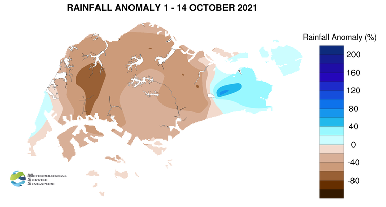
9     Most parts of the island recorded below-average rainfall in the first fortnight of October 2021. About 69% below-average rainfall was recorded at Tengah. The rainfall recorded around Simei was about 74% above-average.


CLIMATE STATION STATISTICS

Long-term Statistics for October
(Climatological reference period: 1991 – 2020)

Average daily maximum temperature: 31.8 °C
Average daily minimum temperature: 25.0 °C
Average monthly temperature: 27.9 °C
Average rainfall: 168.3 mm
Average number of rain days: 15


Historical Extremes for October
(Rainfall since 1869 and temperature since 1929)

Highest monthly mean daily maximum temperature: 33.0 °C (2002)
Lowest monthly mean daily minimum temperature: 22.8 °C (1964)
Highest monthly rainfall ever recorded: 497.1 mm (1942)
Lowest monthly rainfall ever recorded: 10.8 mm (2002)


August 16, 2021

More Thundery Showers for Rest of August 2021

Singapore, 16 August 2021 – The prevailing Southwest Monsoon conditions are forecast to persist over Singapore and the surrounding region in the second fortnight of August 2021, with the low-level winds blowing from the southeast or southwest. On a few days during the fortnight, the winds could shift to blow from the east.

2    With the monsoon rain band forecast to remain over the equatorial Southeast Asia region for the rest of the month, Singapore can expect more wet days in the coming fortnight. During the period, short-duration thundery showers are forecast over parts of the island in the afternoon on most days, and the showers could extend into the evening on a few of these days. On a few days during the fortnight, widespread moderate to heavy thundery showers are expected due to the presence of large-scale convergence of winds over Singapore and the surrounding region. In addition, the passage of Sumatra squalls could bring widespread thundery showers and gusty winds over the island on a few mornings. Overall, the total rainfall for August 2021 is forecast to be above average over most parts of the island.

3    The daily temperature on most days in the second fortnight of August 2021 is forecast to range between 24°C and 33°C. Although showers are expected on most days of the fortnight, the daily maximum temperature could still reach a high of around 34°C on a few days. Relatively warm and humid nights with minimum night-time temperatures of up to 28°C, particularly over the eastern and southern coastal areas of the island can be expected on a few days when prevailing southeast winds bring warm, humid air from the surrounding seas.

4      For updates of the daily weather forecast, please visit our MSS website (https://www.weather.gov.sg), NEA website (www.nea.gov.sg), or download the myENV app.


REVIEW (1 – 15 August 2021)

5      In the first half of August 2021, Southwest Monsoon conditions persisted over the region, and the low-level winds were blowing from the southeast or southwest.

6      Compared to the second fortnight of July 2021, the first fortnight August 2021 was wetter due to a return of showers in the region. During the first fortnight of the month, thundery showers fell mostly in the afternoon and there were a few days where Sumatra squalls brought thundery showers in the morning. On 1 August 2021 in particular, a Sumatra squall brought heavy thundery showers with gusty winds over many parts of Singapore in the morning. The daily total rainfall of 97.8mm recorded at Choa Chu Kang that day was the highest daily rainfall for the first half of August 2021.

7      The return of showers in the first fortnight of August 2021 brought some respite to the warm weather in the second half of July 2021. On most days in the first two weeks of August 2021, the highest daily maximum temperature was below 34°C. The lowest daily minimum temperature recorded during the period was 21.9°C at Pulau Ubin on 3 August 2021.

8      There were still a few warm days in the first fortnight of August 2021. The highest daily maximum temperature of 34.9°C was recorded at Marina Barrage on 3 August 2021. There were also a few warm nights, particularly over the southern and south-eastern parts of the island where the night-time minimum temperature was around 28.0°C.

9      Slightly more than half of the island recorded above average rainfall in the first half of August 2021, with most of the rain falling in the western half of Singapore. The highest anomaly of 128% above average was recorded at Jurong West. The anomaly was lowest at Yio Chu Kang at 37% below average.


CLIMATE STATION STATISTICS

Long-term Statistics for August
(Climatological reference period: 1991 – 2020)

Average daily maximum temperature 31.4 °C
Average daily minimum temperature 25.3 °C
Average monthly temperature 28.1 °C
Average rainfall 146.9 mm
Average number of rain days 14


Historical Extremes for August
(Rainfall since 1869 and temperature since 1929)

Highest monthly mean daily maximum temperature: 32.7 °C (2019)
Lowest monthly mean daily minimum temperature: 23.0 °C (1962)
Highest monthly rainfall ever recorded: 526.8 mm (1878)
Lowest monthly rainfall ever recorded: 11.8 mm (2019)


August 2, 2021

More Thundery Showers Expected in the First Half of August 2021

Singapore, 2 August 2021 – In the first fortnight of August 2021, more thundery showers are expected compared to the last fortnight of July 2021. During the period, the prevailing Southwest Monsoon conditions are expected to persist over Singapore and the surrounding region, with low-level winds forecast to continue blowing from the southeast or southwest.

2    In the first fortnight of August 2021, the monsoon rain band is forecast to lie close to the Equator. This is expected to bring more rainfall over the equatorial Southeast Asia region. On most days in the fortnight, short-duration thundery showers are expected between the late morning and afternoon over parts of the island. On some of these days, the thundery showers could be heavy due to strong day-time heating of land areas coupled with convergence of winds over Singapore and the surrounding vicinity. On a few days in the fortnight, the passage of a Sumatra squall is expected to bring widespread thundery showers with gusty winds to Singapore between the predawn hours and morning. The rainfall for the first fortnight of August 2021 is forecast to be above average over most parts of the island.

3     While more showers are expected in the coming fortnight, there could still be a few warm days with daily highs of around 34°C. On most days, the daily temperature is forecast to range between 24°C and 33°C. On a few nights, it can be relatively warm and humid when southeast winds blow warm and humid air from the sea toward land. Night-time minimum temperatures of up to 28°C can be expected, particularly over the eastern and southern coastal areas of the island.

4      For updates of the daily weather forecast, please visit our MSS website (https://www.weather.gov.sg), NEA website (www.nea.gov.sg), or download the myENV app.


REVIEW (1 – 31 July 2021)

5      In July 2021, Southwest Monsoon conditions prevailed over Singapore and the surrounding region, and the low-level winds blew mostly from the southeast or southwest. There were some days when the winds blew from the west.

6      The first half of July 2021 was much wetter than the second half of the month. Thundery showers fell over parts of the island between the late morning and afternoon on most days due to strong day-time heating of land areas. Large scale convergence of winds over Singapore and the surrounding region brought moderate to heavy thundery showers on a few days. On  12 and 13 July 2021 in particular, there were several spells of widespread moderate to heavy thundery showers with occasional gusty winds over Singapore. The daily total rainfall of 114.2mm recorded at Bukit Panjang on 13 July 2021 was the highest daily total rainfall for July 2021. The highest daily total rainfall on 12 July was 100.2mm at Ulu Pandan.

7       In July 2021, there were 14 days with daily maximum temperatures above 34°C. Most of these days were in the second half of the month where the weather was generally dry and warm. There were also several warm nights, particularly over the southern and south-eastern parts of the island where the night-time minimum temperature was around 28.0°C.

8       The highest daily maximum temperature for July 2021 was 35.2°C recorded at Marina Barrage on 30 July 2021. The lowest daily minimum temperature of 22.5°C was recorded at Admiralty on 13 July 2021.

9       The rainfall was above average over many parts of the island in July 2021. The highest rainfall anomaly of 108% above average was recorded at Tai Seng. The anomaly was lowest at Tuas at 22% below average.


CLIMATE STATION STATISTICS

Long-term Statistics for August
(Climatological reference period: 1991 – 2020)

Average daily maximum temperature 31.4 °C
Average daily minimum temperature 25.3 °C
Average monthly temperature 28.1 °C
Average rainfall 146.9 mm
Average number of rain days 14


Historical Extremes for August
(Rainfall since 1869 and temperature since 1929)

Highest monthly mean daily maximum temperature: 32.7 °C (2019)
Lowest monthly mean daily minimum temperature: 23.0 °C (1962)
Highest monthly rainfall ever recorded: 526.8 mm (1878)
Lowest monthly rainfall ever recorded: 11.8 mm (2019)


July 1, 2021

More Thundery Showers Expected in the Next Fortnight


Singapore, 1 July 2021 – The prevailing Southwest Monsoon conditions are forecast to persist over Singapore and the surrounding region in July 2021. In the coming fortnight, the low-level winds are expected to continue blowing from the southeast or southwest, and the monsoon rain band is forecast to lie over the equatorial Southeast Asia region. This is expected to bring more showers over Singapore compared to the last fortnight of June 2021.

2   In the first week of July 2021, short-duration thundery showers are expected mostly between the morning and early afternoon. On a few of these days, prevailing winds in the region are forecast to converge over Singapore and the surrounding vicinity. This may influence the development of Sumatra squalls and bring widespread thundery showers and gusty winds over Singapore between the predawn hours and morning. In the latter half of the fortnight, localised short-duration thundery showers can be expected on most days due to strong day-time heating of land areas. Overall, the rainfall for the first half of July 2021 is expected to be near normal over most parts of the island.

3     During the fortnight, the daily temperature on most days is forecast to range between 24°C and 33°C. There can be a few warm days, particularly in the latter half of the fortnight where the maximum temperature could reach around 34°C. On a few nights, warm and humid conditions with night-time minimum temperatures of 28°C can be expected when prevailing winds from the southeast or south blow warm and humid air from the sea.

4      For updates of the daily weather forecast, please visit our MSS website (https://www.weather.gov.sg), NEA website (www.nea.gov.sg), or download the myENV app.


REVIEW (1 – 30 June 2021)

5    Southwest Monsoon conditions prevailed over Singapore and the surrounding region in June 2021. During this period, the low-level winds blew mostly from the southeast or southwest.

6    During the month, short-duration thundery showers fell over parts of the island mostly between the late morning and early afternoon. On a few days, the eastward passage of Sumatra squalls from the Strait of Malacca to the South China Sea brought thundery showers and gusty winds over Singapore in the early morning and in the night. On 29 June 2021, convergence of prevailing winds over Singapore and the surrounding region brought a few spells of thundery showers over many parts of the island in the morning, afternoon, and again in the night. The highest daily total rainfall recorded that day was 134.4mm at Pasir Panjang. This was the highest daily total rainfall for June 2021.

7    June 2021 was a generally warm month. There were 17 days where the daily maximum temperature across the island was above 34°C. The highest daily maximum temperature of 35.5°C was recorded at Marina Barrage on 4 June 2021. There were several warm nights in the first half of the month where the minimum night-time temperatures ranged between 28.0°C and 29.2°C, particularly over the southern parts of the island. The lowest daily minimum temperature recorded in June 2021 was 22.1°C on 13 and 29 June arising from spells of thundery showers that fell throughout most parts of the day and night.

8    In June 2021, rainfall was above average over most parts of Singapore. The highest rainfall anomaly of 84% above average was recorded at Lim Chu Kang. The anomaly was lowest at Changi at 31% below average.


CLIMATE STATION STATISTICS

Long-term Statistics for July
(Climatological reference period: 1991 – 2020)

Average daily maximum temperature 31.4 °C
Average daily minimum temperature 25.4 °C
Average monthly temperature 28.2 °C
Average rainfall 146.6 mm
Average number of rain days 14


Historical Extremes for July
(Rainfall since 1869 and temperature since 1929)

Highest monthly mean daily maximum temperature: 32.4 °C (1997)
Lowest monthly mean daily minimum temperature: 22.9 °C (1975)
Highest monthly rainfall ever recorded: 527.3 mm (1890)
Lowest monthly rainfall ever recorded: 12.2 mm (2019)