Category Archives: News

November 1, 2017

More Thundery Showers Expected in The First Half of Nov 2017

Expect more afternoon thundery showers in 1st half of Nov’17. Showers could extend into the evening on a few days.

Singapore, 1 November 2017 – Singapore and the surrounding region are experiencing inter-monsoon conditions which are expected to prevail in November 2017. The inter-monsoon period is characterised by more rainfall and light winds that are variable in direction. Climatologically, lightning activity during the inter-monsoon period is highest during the year.

2          November is normally the second wettest month of the year after December. For the first half of November 2017, short-duration moderate to heavy thundery showers are forecast mostly in the afternoon on six or eight days. On a few of these days, the thundery showers could extend into the evening, and high lightning activity can be expected. On two or three days during the first fortnight of the month, Sumatra squalls moving eastward across Singapore towards the South China Sea could bring widespread thundery showers accompanied by gusty winds to the island between the predawn hours and early morning. Rainfall for the first fortnight of November 2017 is expected to be above normal.

3          In the first half of November 2017, the daily temperature on most days is forecast to range between 24°C and 33°C. On a few days, the daily maximum temperature could reach a high of 34°C, in particular on fine weather days when there are few clouds in the sky and winds that are light.

4          For updates of the daily weather forecast, please visit our MSS website (https://www.weather.gov.sg), NEA website (www.nea.gov.sg), or download the myENV app, MSS’ Weather@SG app.

REVIEW (1 – 31 October 2017)

5          Southwest Monsoon conditions with low level winds blowing from the southeast or southwest prevailed over Singapore and the surrounding region in the first half of October 2017. In the third week of the month, the Southwest Monsoon eased to give way to inter-monsoon conditions where winds weakened to become light and variable in direction.

6          Except for the third week of the month, it was relatively wet in October 2017. The dry and warm conditions in the third week of October 2017 was due to stable atmospheric conditions as warm and dry air prevailed over Singapore and the surrounding region. During the month, most of the thundery showers fell in the late morning and afternoon, and on a few days, extended into the evening. The thundery showers were due to strong solar heating of land areas coupled with the convergence of winds over Singapore and the surrounding vicinity. The occurrence of Sumatra squalls on several days also brought moderate to heavy thundery showers to many parts of Singapore between midnight and early morning. The heaviest daily rainfall recorded during the period was 129.8mm around Tuas on 12 October 2017. There were 21 rain days1 in October 2017, three days more than the long term mean for October. This ties with the highest number of rain days for October recorded in 1985 and 2003.

7          The daily temperature in October 2017 ranged between 22.6°C and 35.3°C. During the week of 16 October 2017, when conditions were warm and dry, there were five days when the daily maximum temperature was more than 34°C. At the Changi climate station, the highest daily maximum temperature recorded was 34.6°C on 18 October 2017. This ties with the highest daily maximum temperature ever recorded at our climate station in October (in 2002 and 2016). The mean monthly temperature recorded for October 2017 was 28.1°C, which is 0.5°C warmer than the long-term mean for October.

8          About half of Singapore received above normal rainfall in October 2017. The highest rainfall of 286.4mm (33% above average) was recorded around MacRitchie Reservoir. Rainfall was lowest around Admiralty where 114.8mm (46% below average) was recorded.

1A rain day is defined as a day where 0.2mm or more of rain was recorded.

FortnightRain_Anomaly_201710bb

CLIMATE STATION STATISTICS FOR November (Climatological reference period: 1981 – 2010)

Mean daily maximum temperature 31.1 °C
Mean daily minimum temperature 24.3 °C
Mean monthly temperature 27.0 °C
Mean rainfall for the month 258.5 mm
Mean number of rain days 18
Highest monthly mean daily maximum temperature 32.0 °C (1997)
Lowest monthly mean daily minimum temperature 23.6 °C (1981, 1983, 1991)
Highest monthly rainfall 508.4 mm (1989)
Lowest monthly rainfall 53.5 mm (1981)

October 16, 2017

Inter-monsoon Conditions Expected in The Second Half of October 2017

Dry and warm weather expected on a few days

Singapore, 16 October 2017 – The prevailing Southwest Monsoon conditions are forecast to weaken and give way to Inter-monsoon conditions in the second half of October 2017. During the second fortnight of October 2017, the low level winds are forecast to be light and variable in direction, characteristic of the inter-monsoon season which is expected to extend into November 2017.

2          Compared to the first half of October 2017 where thundery showers fell over the island on most days, the second half of October 2017 can expect a mix of dry and wet weather conditions. In the third week of October 2017, a few dry and warm weather days can be expected, and for the rest of the second fortnight, short-duration thundery showers are forecast to fall mostly in the afternoon on four to six days. On a few of these days, the thundery showers could extend into the evening. In addition, on one or two days, the eastward passage of Sumatra squalls could bring widespread thundery showers accompanied by gusty winds over Singapore between the predawn hours and early morning. Overall, the rainfall for October 2017 is expected to be slightly above normal.

3          The daily temperature on most days in the second fortnight of October 2017 is forecast to range between 24°C and 33°C. On a few days when the weather is expected to be dry and warm, or when there is strong solar heating coupled with winds that are light, the daily maximum temperature could lie between 34°C and 35°C.

4          For updates of the daily weather forecast, please visit our MSS website (https://www.weather.gov.sg), NEA website (www.nea.gov.sg), or download the myENV app, or the MSS’ Weather@SG app.

Review: 1 – 15 October 2017

5          In the first fortnight of October 2017, Southwest Monsoon conditions prevailed over Singapore and the surrounding region, and the low level winds were blowing mostly from the southeast or southwest.

6          During the review period, Singapore experienced thundery showers mostly in the afternoon and evening due to strong solar heating of land areas coupled with convergence of winds over Singapore and the immediate surrounding vicinity. On a few days, the eastward passage of Sumatra squalls brought widespread thundery showers and gusty winds to Singapore between midnight and the early morning. In the first fortnight of October 2017, the highest daily rainfall of 129.8mm was recorded around Tuas on 12 October 2017.

7          Despite the wet weather conditions that fell over the island on most days in the first fortnight of the month, there were a few warm days where the highest temperature recorded was 35°C around the Ang Mo Kio area on 15 October 2017. The lowest daily minimum temperature recorded ranged between 22.6°C and 22.9°C.

8           In the first half of October 2017, most parts of Singapore received above-normal rainfall. The highest rainfall of 216.0mm (116% above average) was recorded around the Tai Seng area. Rainfall was lowest around Sentosa where 39.0mm (53% below average) was recorded.FortnightRain_Anomaly_201710a


CLIMATE STATION STATISTICS FOR OCTOBER (Climatological reference period: 1981 – 2010)

Mean daily maximum temperature 31.7 °C
Mean daily minimum temperature 24.7 °C
Mean monthly temperature 27.6 °C
Mean rainfall for the month 154.6 mm
Mean number of rain days 15
Highest monthly mean daily maximum temperature 33.0 °C (2002)
Lowest monthly mean daily minimum temperature 23.8 °C (1982)
Highest monthly rainfall 351.4 mm (2003)
Lowest monthly rainfall 10.8 mm (2002)

October 2, 2017

Inter-Monsoon Conditions to Onset around Mid-October 2017

More thundery showers expected in the coming fortnight

Singapore, 2 October 2017 – The prevailing Southwest monsoon conditions with low level winds blowing from the southeast or southwest, will continue into the first fortnight of October 2017. However, these conditions are forecast to gradually transit to inter-monsoon conditions around the end of the fortnight, where the prevailing winds are expected to shift to become light and variable in direction.

2           With the transition to inter-monsoon conditions around mid-October 2017, an increase in the occurrence of thundery showers can be expected in the first two weeks of the month. The thundery showers which are expected on six to eight days of the first fortnight are likely to fall mostly in the late morning and afternoon, and may extend into the evening on a few days. In addition, on two or three days during this fortnight, the eastward passage of Sumatra squalls could bring widespread thundery showers accompanied by occasional gusty winds over Singapore between the predawn hours and morning.
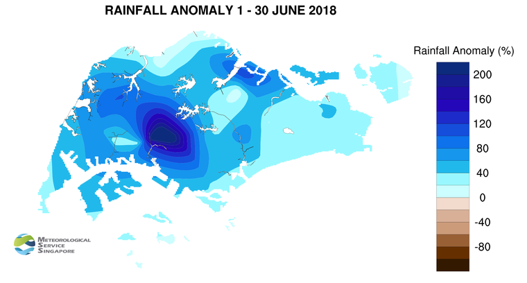
 The rainfall for the first two weeks of October 2017 is expected to be above normal.

3          The daily temperature on most days in the first two weeks of October 2017 is forecast to range between 24°C and 33°C. There could be a few days where the daily maximum temperature could reach around 34°C, and on a few rainy days, the daily minimum temperature could fall to around 22°C.

4          For updates of the daily weather forecast, please visit our MSS website (https://www.weather.gov.sg), NEA website (www.nea.gov.sg), or download the myENV app, or the MSS’ Weather@SG app.

Review: 1 – 30 September 2017

5          In September 2017, Southwest Monsoon conditions prevailed over Singapore, and the low level winds were blowing mostly from the southeast or southwest.

6          The total rainfall recorded was higher in the second half of September 2017 compared to the first half of the month. On most days of the month, Singapore experienced thundery showers in the late morning and afternoon due to strong solar heating of land areas coupled with convergence of winds over Singapore and the surrounding vicinity. On a couple of days, the thundery showers were due to the passage of Sumatra squalls that moved over Singapore in the predawn hours and early morning. The heaviest daily rainfall of 94mm was recorded on 10 September 2017 around the Sungei Kadut area.

7          There were a few warm days during the month where the daily maximum temperature reached a high of between 34.1°C and 34.9°C. The lowest daily minimum temperature recorded ranged between 21.9°C and 22.9°C on a few days where it rained for most parts of the day. At the Changi climate station, the mean monthly temperature recorded for September 2017 was 28.0°C, which is 0.4°C higher than the long-term mean temperature for September.

8          Most parts of Singapore received above-normal rainfall in September 2017. The highest rainfall of 320.2mm (68% above average) was recorded around the Jurong area. Rainfall was lowest in the eastern part of the island where 124.4mm (22% below average) was recorded around the Changi area.

FortnightRain_Anomaly_201709b


CLIMATE STATION STATISTICS FOR OCTOBER (Climatological reference period: 1981 – 2010)

Mean daily maximum temperature 31.7 °C
Mean daily minimum temperature 24.7 °C
Mean monthly temperature 27.6 °C
Mean rainfall for the month 154.6 mm
Mean number of rain days 15
Highest monthly mean daily maximum temperature 33.0 °C (2002)
Lowest monthly mean daily minimum temperature 23.8 °C (1982)
Highest monthly rainfall 351.4 mm (2003)
Lowest monthly rainfall 10.8 mm (2002)

September 15, 2017

Southwest Monsoon Conditions to Persist For Rest of September 2017

Thundery showers provide some respite to warm days

Singapore, 15 September 2017 – The Southwest Monsoon season has been prevailing since June 2017 and is forecast to persist for the rest of the month. The low level winds over Singapore and the surrounding region are forecast to blow mostly from the southeast or southwest. On some mornings the winds are expected to be generally light and variable in direction.

2          In the second half of September 2017, Singapore can expect thundery showers on six to eight days, mostly in the late morning and early afternoon. In addition, on two or three days in the coming fortnight, widespread thundery showers accompanied by occasional gusty winds, arising from the passage of Sumatra squalls can be expected between the pre-dawn hours and morning. The total rainfall for September 2017 is expected to be slightly above normal.

3          On most days during the fortnight, the daily temperature is expected to range between 24°C and 33°C. On a few days, it is likely to be warm with the daily maximum temperature reaching a high of around 34°C. The lowest daily minimum temperature in the next two weeks could fall to around 23°C on one or two rainy days.

4          For updates of the daily weather forecast, please visit our MSS website (https://www.weather.gov.sg), NEA website (www.nea.gov.sg), or download the myENV app, or the MSS’ Weather@SG app.

Review: 1 – 14 September 2017

5          Southwest Monsoon conditions prevailed over Singapore and the surrounding region in the first fortnight of September 2017. The low level winds during the two weeks were predominantly from the southeast or south.

6         In the first half of September 2017, Singapore experienced thundery showers mostly in the late morning and early afternoon due to strong solar heating of land areas coupled with convergence of winds over Singapore and the surrounding vicinity. On a few days, the thundery showers were due to the passage of a Sumatra squall that moved over Singapore in the predawn and early morning. The heaviest daily rainfall of 94mm was recorded on 10 September 2017 around the Sungei Kadut area.

7          There were a few warm days during the fortnight where the daily maximum temperature reached a high of between 34.1°C and 34.4°C.  The lowest daily minimum temperature recorded ranged between 22.9°C and 23.5°C. At the Changi climate station, the mean monthly temperature recorded for the first fortnight of September 2017 was 28.2°C, which is 0.6°C higher than the long-term mean temperature for September.

8          Most parts of Singapore received below-normal rainfall in the first fortnight of September 2017. The lowest rainfall of 24.1mm (69% below average) was recorded around the Paya Lebar area. Rainfall was highest around the Bukit Panjang area where 146.4mm (53% above average) was recorded.

FortnightRain_Anomaly_201708bb

CLIMATE STATION STATISTICS FOR SEPTEMBER (Climatological reference period: 1981 – 2010)

Mean daily maximum temperature 31.4 °C
Mean daily minimum temperature 24.8 °C
Mean monthly temperature 27.6 °C
Mean rainfall for the month 156.5 mm
Mean number of rain days 13
Highest monthly mean daily maximum temperature 32.2 °C (1997)
Lowest monthly mean daily minimum temperature 23.6 °C (1986)
Highest monthly rainfall 440.4 mm (1988)
Lowest monthly rainfall 23.7 mm (1994)

August 31, 2017

More Showers Expected for First Half of September 2017

Warm conditions expected on a few days

Singapore, 31 August 2017 – The prevailing Southwest Monsoon season is forecast to extend into September 2017. During this period, the low level winds over Singapore and the surrounding region typically blow from the southeast or southwest, and showers usually occur in the afternoon.

2          In the first half of September 2017, it is expected to be wetter than the last fortnight of August 2017.  Short-duration thundery showers due either to strong solar heating of land areas and/or convergence of winds over Singapore and the surrounding vicinity can be expected between the late morning and afternoon on seven or eight days. On one or two days during the fortnight, widespread thundery showers accompanied with gusty winds (due to the passage of squall lines from the Strait of Malacca over Singapore) are expected between the predawn hours and morning. Rainfall for the first half of September 2017 is expected to be slightly above normal.

3          On most days during the first fortnight of September 2017, the daily temperature is expected to range between 24°C and 33°C. On a few days in the fortnight, warm conditions can be expected where the daily maximum temperature could reach a high of around 34°C. The daily minimum temperature could fall to around 22°C on a few rainy days.

4          For updates of the daily weather forecast, please visit our MSS website (https://www.weather.gov.sg), NEA website (www.nea.gov.sg), or download the myENV app, or the MSS’ Weather@SG app.

Review: 1 – 30 August 2017

5          Southwest Monsoon conditions prevailed over Singapore and the surrounding region in August 2017. The low level winds blew predominantly from the southeast or south during the month.

6         The thundery showers experienced in Singapore in August 2017 fell mostly in the late morning and afternoon, and were due to strong solar heating of land area coupled with the convergence of winds over Singapore and the surrounding vicinity. There were a few days when the thundery showers fell in the predawn hours and early morning due to Sumatra squalls moving across Singapore. The heaviest daily rainfall of 116.8mm was recorded on 6 August 2017 around the Lim Chu Kang area.

7          During the month, there were a few warm days where the daily maximum temperature reached a high of between 34.1°C and 34.4°C.  The lowest daily minimum temperature recorded ranged between 21.7°C and 22.7°C. At the Changi climate station, the mean monthly temperature recorded for August 2017 was 28.1°C, which is slightly warmer than the long-term August average of 27.9°C.

8          Most parts of Singapore received below-normal rainfall in August 2017. The lowest rainfall of 83.8mm (48% below average) was recorded around the Tanjong Katong area. Rainfall was highest around the Choa Chu Kang area where 255.8mm (39% above average) was recorded.

FortnightRain_Anomaly_201708bb


CLIMATE STATION STATISTICS FOR SEPTEMBER (Climatological reference period: 1981 – 2010)

Mean daily maximum temperature 31.4 °C
Mean daily minimum temperature 24.8 °C
Mean monthly temperature 27.6 °C
Mean rainfall for the month 156.5 mm
Mean number of rain days 13
Highest monthly mean daily maximum temperature 32.2 °C (1997)
Lowest monthly mean daily minimum temperature 23.6 °C (1986)
Highest monthly rainfall 440.4 mm (1988)
Lowest monthly rainfall 23.7 mm (1994)

August 16, 2017

Expect Wet Weather Conditions in The Second Half of August 2017

A few warm days can still be expected

Singapore, 16 August 2017 – In the second half of August 2017, Singapore and the surrounding region will continue to be influenced by Southwest Monsoon conditions, characterised by low level winds that blow predominantly from the southeast or southwest.

2          The wet weather conditions experienced in the first half of August 2017 are forecast to persist in the second fortnight of August 2017. During the period, short-duration thundery showers due to strong solar heating of land areas are expected on six to eight days, mostly in the late morning and early afternoon. On one or two days within the upcoming two weeks, the occurrence of Sumatra squalls could bring widespread thundery showers accompanied with gusty winds to Singapore between the predawn and early morning. Overall, the rainfall for August 2017 is forecast to be near-normal.

3          The daily temperature for the rest of the month is not expected to deviate significantly from that experienced in the first two weeks of August 2017. On most days, the daily temperature is expected to range between 25°C and 33°C, and on a few days in the later part of the month, warm conditions can be expected with the daily maximum temperature reaching a high of around 34°C.  During the fortnight, the daily minimum temperatures could register a value between 22°C and 23°C, in particular when rain falls over the island for most part of the day.

4          For updates of the daily weather forecast, please visit our MSS website (https://www.weather.gov.sg), NEA website (www.nea.gov.sg), or download the myENV app, or the MSS’ Weather@SG app.

Review: 1 – 15 August 2017

5          In the first fortnight of August 2017, Southwest Monsoon conditions prevailed over Singapore and the surrounding region, with the low level winds blowing predominantly from the southeast or south.

6          Compared to the second half of July 2017 where Singapore experienced several days of dry and warm conditions and with few days of rainfall, the first fortnight of August 2017 experienced wetter weather conditions. The thundery showers in the first half of August 2017 occurred between the late morning and early afternoon on most days and between the predawn and early morning on a few days. The showers were due to convergence of winds either over Singapore or in our immediate surrounding vicinity. The rain was heaviest on 6 August 2017 around the Lim Chu Kang area where the highest daily rainfall recorded was 116.8mm.

7          Although it rained on most days during the first half of the month, there were still a few warm days. The highest daily maximum temperature during the first fortnight ranged between 34.1°C and 34.4°C, and the lowest daily minimum temperature was between 21.7°C and 23.3°C.   At the Changi climate station, the mean monthly temperature recorded in the first half of August 2017 was 28.2°C, which is 0.3°C higher than the long-term mean of 27.9°C for August.

8          About two-third of Singapore received below-normal rainfall in first fortnight of August 2017. The lowest rainfall of 12.4mm (48% below average) was recorded around the Tanjong Katong area. Rainfall was highest around the Choa Chu Kang area where 216.0mm (135% above average) was recorded.

FortnightRain_Anomaly_201708a


CLIMATE STATION STATISTICS FOR AUGUST (Climatological reference period: 1981 – 2010)

Mean daily maximum temperature 31.4 °C
Mean daily minimum temperature 25.0 °C
Mean monthly temperature 27.9 °C
Mean rainfall for the month 148.9 mm
Mean number of rain days 14
Highest monthly mean daily maximum temperature 32.6 °C (1997)
Lowest monthly mean daily minimum temperature 23.9 °C (1989)
Highest monthly rainfall 327.3 mm (2008)
Lowest monthly rainfall 45.1 mm (1994)

August 1, 2017

Brief Respite to the Dry and Warm Weather in First Half of August 2017

A few warm days can still be expected

Singapore, 1 August 2017 – The prevailing Southwest Monsoon conditions are expected to persist in the first fortnight of August 2017.  During this period, the low level winds are forecast to blow from the southeast or southwest.

2          Compared to the dry weather conditions experienced in the past fortnight, higher rainfall can be expected in the first fortnight of August 2017. Short-duration thundery showers are expected on six to eight days between the late morning and early afternoon, and widespread thundery showers accompanied with gusty winds due to Sumatra squalls on one or two days between the predawn and early morning. The rainfall for the first half of August 2017 is forecast to be normal.

3          Although showers are expected on most days in the coming fortnight, a few warm days with daily maximum temperatures reaching as high as 34°C can still be expected. On most days, the daily maximum and minimum temperatures are forecast to be 32°C- 33°C and 23°C-25°C respectively.

4          For updates of the daily weather forecast, please visit our MSS website (https://www.weather.gov.sg), NEA website (www.nea.gov.sg), or download the myENV app, or the MSS’ Weather@SG app.

Review: 1 – 31 July 2017

5          In July 2017, Southwest Monsoon conditions prevailed over the region with low level winds blowing mainly from the southeast or south.

6          The first half of the month was wet with moderate to heavy rain over many parts of the island on most days. Most of the thundery showers fell between the late morning and early afternoon. On a few days, the thundery showers were due to the passage of a Sumatra squall that moved over Singapore in the predawn and early morning. The thundery showers were heaviest on 14 July 2017 where the highest daily rainfall recorded was 110.6mm around the Bukit Timah area. In contrast, the second half of July 2017 was generally dry and warm except for some localised showers on a few days.

7          There were several cool nights in the first half of July 2017 due to the moderate to heavy showers experienced during the day. The daily minimum temperature recorded on 10 days in the first half of July 2017 ranged between 22.3°C and 24°C. In comparison, the daily minimum temperatures in the second half of July 2017 ranged between 24.4°C and 26.1°C, and the daily maximum temperatures were between 32.2°C and 34.5°C. At the Changi climate station, the mean monthly temperature recorded for July 2017 was 28.3°C, which is 0.4°C higher than the long-term mean of 27.9°C for July.

8          Most parts of Singapore received below normal rainfall in July 2017. The lowest rainfall of 79.6mm (48% below average) was recorded around the Changi area. Rainfall was highest around the Thomson area where 204.6mm (2% above average) was recorded.

FortnightRain_Anomaly_201707bb


CLIMATE STATION STATISTICS FOR AUGUST (Climatological reference period: 1981 – 2010)

Mean daily maximum temperature 31.4 °C
Mean daily minimum temperature 25.0 °C
Mean monthly temperature 27.9 °C
Mean rainfall for the month 148.9 mm
Mean number of rain days 14
Highest monthly mean daily maximum temperature 32.6 °C (1997)
Lowest monthly mean daily minimum temperature 23.9 °C (1989)
Highest monthly rainfall 327.3 mm (2008)
Lowest monthly rainfall 45.1 mm (1994)

July 17, 2017

Dry Weather Expected in Second Half of July 2017

Short-duration thundery showers on some days

Singapore, 17 July 2017 – In the second half of July 2017, the weather in Singapore will continue to be influenced by the prevailing Southwest Monsoon, and the low level winds during the period are forecast to blow mostly from the southeast or southwest.

2          For the rest of the month, Singapore can expect four to six days of short-duration thundery showers, mostly in the afternoon, due to strong solar heating of land areas. On one or two days between the predawn and morning, the passage of a Sumatra squall could bring widespread thundery showers with occasional gusty winds to Singapore. The rainfall for July 2017 is forecast to be normal.

3          Compared to the wet weather experienced in the first half of July 2017, the second fortnight of the month is expected to be generally dry and warm. On most days in the second half of July 2017, the daily maximum temperatures are forecast to range between 32°C and 33°C, and could reach a high of around 34°C on a few days.

4          For updates of the daily weather forecast, please visit our MSS website (https://www.weather.gov.sg), NEA website (www.nea.gov.sg), or download the myENV app, or the MSS’ Weather@SG app.

Review: 1 – 16 July 2017

5          Southwest Monsoon conditions prevailed over Singapore and the region in the first fortnight of July 2017. During this period, the low level winds were blowing predominantly from the southeast or southwest.

6          In the first half of July 2017, Singapore experienced moderate to heavy thundery showers on most days between the late morning and early afternoon. The showers were due to strong solar heating of land areas coupled with convergence of winds over Singapore and the immediate surrounding vicinity. The wet weather in the first fortnight of the month was also due to the passage of Sumatra squalls which brought widespread thundery showers with gusty winds to Singapore on some days between the predawn hours and early morning.  During the period, the rain was heaviest on 14 July 2017 in Bukit Timah, where the highest daily rainfall total recorded was 110.6mm.

7          The wet weather in the first fortnight of July 2017 brought several days with cool night time temperatures. The daily minimum temperatures recorded ranged between 22.3°C and 24°C on 10 days. The lowest daily minimum temperature of 22.3°C was recorded around the Marina South area on 12 July 2017. The daily maximum temperature recorded during the fortnight ranged between 28.7°C and 33.7°C.

8          Most parts of Singapore received above normal rainfall in the first fortnight of July 2017. The highest rainfall of 168.4mm (92% above average) was recorded around the Paya Lebar area. Rainfall was lowest around the Changi area where 77.2mm (3% below average) was recorded.

FortnightRain_Anomaly_201707a


CLIMATE STATION STATISTICS FOR JULY (Climatological reference period: 1981 – 2010)

Mean daily maximum temperature 31.3 °C
Mean daily minimum temperature 25.0 °C
Mean monthly temperature 27.9 °C
Mean rainfall for the month 154.4 mm
Mean number of rain days 14
Highest monthly mean daily maximum temperature 32.4 °C (1997)
Lowest monthly mean daily minimum temperature 23.8 °C (1981)
Highest monthly rainfall 305.4 mm (1988)
Lowest monthly rainfall 18.6 mm (1997)

June 30, 2017

Wet Weather Conditions to Persist in First Half of July 2017

A few warm days can still be expected

Singapore, 30 June 2017 – In the first fortnight of July 2017, the weather in Singapore and the surrounding region will continue to be influenced by the prevailing Southwest Monsoon season. During this period, the low level winds are forecast to blow mostly from the southeast or southwest.

2          The wet weather conditions experience in the second half of June 2017 are forecast to persist into the first half of July 2017. Thundery showers due to strong solar heating of land areas are expected mostly in the late morning and early afternoon on five to seven days. In addition, widespread thundery showers with occasional gusty winds due to the passage of a Sumatra squall are expected on two or three mornings during the period. The rainfall for the first half of July 2017 is likely to be normal.

3          On most days in the first two weeks of the month, the daily temperature is expected to range between 25°C and 33°C. In the second half of the fortnight, a few warm days can be expected where the daily maximum temperature could reach a high of around 34°C. The daily minimum temperatures could dip to around 22°C on a few rainy days.

4         For updates of the daily weather forecast, please visit our MSS website (https://www.weather.gov.sg), NEA website (www.nea.gov.sg), or download the myENV app, or the MSS’ Weather@SG app.

Review: 1 – 29 June 2017

5          In June 2017, Southwest Monsoon conditions prevailed over Singapore and the region, and the low level winds were predominantly from the southeast or southwest.

6          There were more showers in the second half of June 2017 compared to the first half of the month. On most days in the month, moderate to heavy thundery showers due to strong solar heating of land areas affected the island in the late morning and afternoon, and extended into the evening on a few days. The passage of Sumatra squalls on a few days, brought widespread thundery showers with gusty winds to Singapore in the morning. The rain was heaviest on 18 June 2017 around the Mandai area where the highest daily rainfall total recorded was 137mm.

7          Singapore experienced dry and warm weather conditions with below average rainfall in the first half of June 2017. During the month, the lowest daily minimum temperature recorded was 21.8°C on 23 June 2017 where the rain was widespread over Singapore. At the Changi climate station, the mean monthly temperature recorded for June 2017 was 28.5°C, which is slightly warmer than the long-term mean of 28.3°C for June.

8          About half of Singapore received below normal rainfall in June 2017. The lowest rainfall of 81.6mm (36% below average) was recorded around the Tanjong Katong area. Rainfall was highest around the Jurong area where 255mm (59% above average) was recorded.


FortnightRain_Anomaly_201706b_amended

CLIMATE STATION STATISTICS FOR JULY (Climatological reference period: 1981 – 2010)

Mean daily maximum temperature 31.3 °C
Mean daily minimum temperature 25.0 °C
Mean monthly temperature 27.9 °C
Mean rainfall for the month 154.4 mm
Mean number of rain days 14
Highest monthly mean daily maximum temperature 32.4 °C (1997)
Lowest monthly mean daily minimum temperature 23.8 °C (1981)
Highest monthly rainfall 305.4 mm (1988)
Lowest monthly rainfall 18.6 mm (1997)

June 16, 2017

More Showers Forecast in Second Fortnight of June 2017

A few warm days can still be expected

Singapore, 16 June 2017 –  The prevailing Southwest Monsoon conditions are expected to persist in the second fortnight of June 2017, and the low level winds are forecast to blow predominantly from the southeast or southwest.

2          In the second half of June 2017, six to eight days of short-duration thundery showers mostly in the late morning and afternoon can be expected. In addition, the passage of a Sumatra squall is expected to bring widespread thundery showers with occasional gusty winds to Singapore between the predawn hours and morning on one or two days. Rainfall for June 2017 is likely to be below normal.

3          While more showers are expected in the second fortnight of June 2017 compared to the first fortnight, the daily maximum temperature could still reach a high of around 35°C on a few days. On most days, the daily temperature is forecast to range between 25°C and 34°C.

4         For updates of the daily weather forecast, please visit our MSS website (https://www.weather.gov.sg), NEA website (www.nea.gov.sg), or download the myENV app, or the MSS’ Weather@SG app.

Review: 1 – 15 June 2017

5          Southwest monsoon conditions prevailed over the region in the first half of June 2017, with the low level winds blowing from the southeast or southwest.

6          During the review period, Singapore experienced dry and warm conditions, particularly in the first week of June 2017. The highest daily maximum temperature was 34.9°C recorded at Choa Chu Kang on 5 June 2017. At the Changi climate station, the night time temperatures on most days ranged between 25.8°C and 28.3°C, well above the long-term climatological June mean minimum temperature of 25.4°C. The warm nights were due to warm and humid air over the sea being blown towards land by the prevailing winds. The mean temperature recorded at the Changi climate station in the first half of June 2017 was 29.1°C, approximately 0.8°C warmer than the long-term mean temperature for June.

7          In the first half of June 2017, short-duration thundery showers occurred over the island mostly in the late morning and early afternoon on a few days due to strong solar heating of land areas. On 14 June 2017, the passage of a Sumatra squall in the morning brought moderate to heavy thundery showers to Singapore. The thundery showers were heaviest on 10 June 2017 where the highest daily rainfall total recorded was 99.6mm around the Tuas area.

8          Most parts of Singapore received below normal rainfall in the first half of June 2017. The lowest rainfall of 8.6mm (87% below average) was recorded around the Changi area. Rainfall was highest around the Choa Chu Kang area where 116.3mm (36% above average) was recorded.

FortnightRain_Anomaly_201706aa


CLIMATE STATION STATISTICS FOR JUNE (Climatological reference period: 1981 – 2010)

Mean daily maximum temperature 32.0 °C
Mean daily minimum temperature 25.4 °C
Mean monthly temperature 28.3 °C
Mean rainfall for the month 130.7 mm
Mean number of rain days 12
Highest monthly mean daily maximum temperature 33.2 °C (1997)
Lowest monthly mean daily minimum temperature 24.4 °C (1989)
Highest monthly rainfall 265.8 mm (1996)
Lowest monthly rainfall 21.8 mm (2009)