Northeast Monsoon conditions with prevailing northeast winds have set in over S’pore. In next fortnight, expect 7-9 days of afternoon thundery showers, and 1-2 days to be cloudy and occasionally windy with widespread rain due to monsoon surge.
Singapore, 30 November 2018 – The Northeast Monsoon season has set in over Singapore and the surrounding region, and is expected to prevail till March 2019. During the season, the prevailing winds over the region are expected to blow mainly from the northeast or northwest.
2 For the next two months, the Northeast Monsoon will be in its wet phase where the monsoon rain band typically lies over the equatorial South China Sea. Over Singapore and the surrounding region, it is likely to be wet with more occurrences of short-duration moderate to heavy thundery showers in the afternoon. On some days during the season, a surge of strong northeasterly winds blowing southward over the South China Sea could bring occasionally windy conditions with frequent spells of widespread rain showers over Singapore and the surrounding vicinity. This strengthening of northeasterly winds over the South China Sea, known as a monsoon surge, can last for between two and five days, and also bring cooler temperatures to Singapore. Between two and four monsoon surge events can be expected during the wet phase of the Northeast Monsoon season.
3 The weather in the first fortnight of December 2018 is expected be wet. On seven to nine days in the fortnight, thundery showers occurring mostly in the afternoon can be expected. On a few of these days, the showers could extend into the evening. A monsoon surge is forecast towards the end of the fortnight. This could bring cloudy and occasionally windy conditions with periods of moderate rain, heavy at times, over Singapore and the surrounding region for one or two days. The prevailing winds are also expected to shift to temporarily blow from the west on one to two days during the fortnight. This could bring thundery showers over the island in the morning from a Sumatra squall. For the first half of December 2018, rainfall is forecast to be above normal.
4 In the first half of December 2018, the daily temperature on most days is expected to range between 24°C and 32°C. There could be a few days during the period where cooler temperatures are expected and the daily minimum temperature recorded could reach a low of between 22°C and 23°C.
5 For updates of the daily weather forecast, please visit our MSS website (https://www.weather.gov.sg), NEA website (www.nea.gov.sg), or download the myENV app, or the MSS’ Weather@SG app.
REVIEW (1 – 29 November 2018)
6 Singapore experienced relatively wet conditions in November 2018. Thundery showers fell over the island on most days of the month.
7 The prevailing winds in November 2018 were mostly light and variable in direction until the end of the month where there was a change in the winds to blow more from the northeast. This change in wind direction in the last week of November 2018 signalled the cessation of the inter-monsoon period and the start of the Northeast Monsoon season.
8 In the first half of November 2018, the light wind conditions coupled with strong solar heating of land areas were conducive for the development of thunderstorm clouds. This brought intense thundery showers in the afternoon over Singapore. In the second half of the month, the prevailing winds blew from the southwest or west for several days, feeding into a low pressure system north of Singapore in the South China Sea. On several days, the thundery showers over Singapore between the early hours and morning were due to Sumatra squalls moving from the Strait of Malacca over the island.
9 The highest daily total rainfall recorded in November 2018 was 110.8mm at Tuas on 21 November 2018. The heavy rainfall that day was caused by an intense Sumatra squall that brought widespread thundery showers accompanied gusty winds over the island. The strongest gust recorded that day was 73.8 km/h at Pasir Panjang. The second highest daily total rainfall of 104.5mm was recorded at Holland Road on 11 November 2018.
10 In November 2018, the daily maximum temperature on most days ranged between 32°C and 34°C. The highest daily maximum temperature recorded was 34.8°C on 28 November 2018 at Clementi. The daily minimum temperature on most days ranged between 23°C and 24°C, and the lowest minimum temperature recorded in the month was 21.4°C on 17 November 2018 at Jurong West.
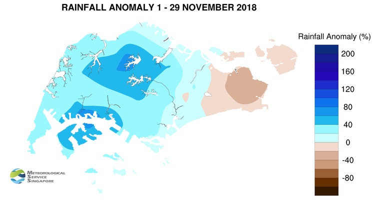
11 Many parts of Singapore received well above average rainfall in November 2018. The highest rainfall of 433.8 mm (80% above average) was recorded at Jurong, and the lowest rainfall of 162 mm (35% below the average) was recorded at Changi.
CLIMATE STATION STATISTICS FOR DECEMBER (Climatological reference period: 1981 – 2010)
| Mean daily maximum temperature |
30.2 °C |
| Mean daily minimum temperature |
24.0 °C |
| Mean monthly temperature |
26.4 °C |
| Mean rainfall for the month |
318.6 mm |
| Mean number of rain days |
18 |
| Highest monthly mean daily maximum temperature |
31.3 °C (1997, 2002) |
| Lowest monthly mean daily minimum temperature |
23.0 °C (1981,1983) |
| Highest monthly rainfall |
765.9 mm (2006) |
| Lowest monthly rainfall |
62.9 mm (1988) |